The Evolution of Commercial Satellite Imagery in the U.S. Government
Author's Prelude
Capturing the evolution of the United States commercial geospatial ecosystem is akin to mapping the Earth itself—no single projection can perfectly capture every detail. Over the past seven decades, this industry was forged by an intricate, sprawling web of intelligence officers, academic researchers, commercial risk-takers, and acquisition professionals. While we have endeavored to highlight the pivotal figures and paradigm-shifting milestones that define this history, no single article can be entirely exhaustive. For every director, CEO, or lawmaker named in this piece, there are countless unsung engineers writing code, analysts studying pixels, and civil servants navigating bureaucratic labyrinths who were equally critical to this success. This narrative is a foundational overview and a tribute to that collective legacy. We acknowledge the inevitable gaps and offer our deepest respect to the broader community of pioneers whose vital contributions may not be explicitly mentioned on these pages.
The Ascendant Role of Commercial Imagery in US Geospatial Intelligence
During the early Space Age, high-resolution overhead reconnaissance was a highly classified national-security capability, even as civil systems such as TIROS and later Landsat opened lower-resolution Earth observation to scientific and public use. Over the following decades, those once-separate worlds increasingly converged. Today, commercial satellite imagery is the indispensable backbone of the United States Government's geospatial intelligence (GEOINT) infrastructure. This sweeping transformation was driven by rapid advancements in private-sector space technology, the strategic necessity of sharing unclassified intelligence with global allies, and the financial agility of commercial procurement.
From tracking natural disasters to piercing the fog of geopolitical conflicts, the accessibility of high-resolution commercial data offers the US government unparalleled adaptability and rapid response capabilities, supplementing traditional classified systems. This report provides a comprehensive historical examination of how the US government fostered this vital domain. It traces the evolution of pivotal acquisition programs including ClearView, NextView, and EnhancedView; the emergence of web-based delivery capabilities such as Rapid Delivery of Online GEOINT (RDOG) and EnhancedView Web Hosting Service (EVWHS); and the eventual transition to today’s Electro-Optical Commercial Layer (EOCL). Finally, it highlights the key individuals, policies, and vital interagency contributions of the National Geospatial-Intelligence Agency (NGA), the National Reconnaissance Office (NRO), the United States Geological Survey (USGS), and the National Oceanic and Atmospheric Administration (NOAA) in shaping the modern commercial geospatial ecosystem.
Laying the Groundwork: Early Commercial Remote Sensing in the United States
📷 View exhibit at the National Air and Space Museum
The initial U.S. commercial forays in satellite-based services emerged first in telecommunications rather than Earth observation. Telstar 1, developed and financed by AT&T and Bell Telephone Laboratories and launched by NASA in 1962, demonstrated the growing potential for privately developed space technology and commercial participation in space. While Telstar 1's primary function was telecommunications, relaying television signals across the Atlantic Ocean, its success laid the groundwork for future commercial endeavors in space. This accomplishment indicated that private entities could successfully operate in space, a crucial step that likely fostered confidence and paved the way for subsequent commercial ventures in areas like remote sensing. The government's early interactions with commercial space capabilities can be observed in the 1964 lease of Hughes Aircraft Company's Syncom 3 satellite to the Department of Defense.
Although primarily a communications satellite, this interaction indicated an initial governmental recognition of the potential advantages of utilizing commercial space assets. This early engagement suggests that the government was beginning to explore how the burgeoning commercial space sector could be leveraged for its own purposes, even if those purposes were not initially focused on intelligence gathering. Concurrently, NASA's Television Infrared Observation Satellites (TIROS) program, active between 1960 and 1966, significantly contributed to meteorological research through the use of satellite imagery. This early program illustrated the potential of satellite-derived data for both public and commercial interests, even though its main focus was on scientific advancement rather than commercial exploitation. The successful use of satellite imagery for weather forecasting demonstrated the tangible benefits of this technology in a civilian domain, likely increasing broader awareness and acceptance of its potential in other fields.
The legal foundation for a private satellite industry in the United States was established by the Land Remote-Sensing Commercialization Act of 1984 (Public Law 98-365). Introduced by Rep. Don Fuqua and signed by President Ronald Reagan on July 17, 1984, the legislation attempted to encourage private involvement in land remote sensing. In his signing statement, Reagan framed the Act primarily in terms of his administration's broader economic philosophy, describing "competitive private sector involvement in land remote sensing" as being "in the national interest" and pledging to "develop a program that requires minimum government involvement". Policy development on the Act ran through the Reagan White House's economic policy apparatus, where Roger B. Porter—then serving simultaneously as Director of the White House Office of Policy Development and Executive Secretary of the Cabinet Council on Economic Affairs—held responsibility for coordinating exactly this category of interagency commercialization policy.
The Act's development also coincided with one of the tenser stretches of the late Cold War: the November 1983 Able Archer 83 NATO exercise, which senior US and Soviet officials have since described as having brought the two superpowers unusually close to miscalculation. Some historians read the Reagan administration's subsequent turn toward technology-sharing and commercialization as functioning, in part, as a good-faith signal alongside more explicit diplomatic overtures in 1984–1985.
The Earth Observation Satellite Company (EOSAT) and Market Genesis
Implementation of the 1984 Act moved quickly. The Department of Commerce ran a competitive Request for Proposals (RFP) process to select an operator for the newly commercialized Landsat system, ultimately awarding the ten-year contract in September 1985 to the Earth Observation Satellite Company (EOSAT)—a joint venture between Hughes Aircraft Company and RCA American Communications. EOSAT took over operation of Landsat 4 and 5, gained exclusive commercial marketing rights to Landsat data, and assumed responsibility for building the follow-on Landsat 6 and 7 satellites. By 1986, General Electric acquired RCA, absorbing its stake in EOSAT and folding the satellite manufacturing assets into its GE Aerospace division. From that point forward, EOSAT operated as a joint venture between Hughes Aircraft and GE Aerospace.
Beyond simply operating satellites, EOSAT's mandate was to build the commercial market for Earth observation data essentially from scratch. EOSAT worked to expand the international ground station network and build a global data distribution partner network, extending Landsat data's reach far beyond the single EROS Data Center in South Dakota. Simultaneously, EOSAT invested heavily in educating the world about remote sensing, supporting training curricula that introduced the technology to practitioners in geology, biology, agriculture, and oil, gas, and mining.
Dr. Shawana P. Johnson, who joined EOSAT in 1989 and later became its Global Executive Sales Manager, remembers that market-building challenge as being much broader than simply selling satellite scenes: “We were never simply selling pixels. We were helping customers see a new way of understanding the Earth: consistently, synoptically, across political borders, and over time.”
By the mid-1990s, however, EOSAT's exclusive-marketing model was under mounting financial strain. High data prices had limited the very commercial market EOSAT was chartered to build, prompting Congress to pass the Land Remote Sensing Policy Act of 1992 (P.L. 102-555) to wind the exclusive-marketing experiment down and return Landsat operations to joint federal management. Concurrently, a new generation of very-high-resolution commercial imaging was taking shape. Lockheed Martin backed a Commercial Remote Sensing Systems (CRSS) venture in 1994, which was later renamed Space Imaging, Inc., to pursue the emerging market for sub-meter commercial satellite imagery. In 1996, Lockheed Martin sold EOSAT to the affiliated Space Imaging, consolidating Landsat's commercial operator with the venture building the next generation of high-resolution imaging under a single corporate roof. Space Imaging was itself acquired by ORBIMAGE in 2006, which then rebranded as GeoEye—directly paving the way for the ClearView and NextView contracts.
This legislative action created the necessary regulatory framework for private companies to engage in satellite operations, including the potential for commercial Earth observation. This legislation was a critical enabler for the future growth of the commercial remote sensing industry, providing the rules and guidelines under which private companies could operate . However, a considerable period followed before a viable commercial land observation satellite industry emerged. It was not until 1993 that WorldView Inc. became the first US company licensed to operate such a satellite. WorldView Imaging Corporation would subsequently contribute its assets to the company formed as EarthWatch, which later changed its name to DigitalGlobe in 2002. That lineage ultimately became one of the principal commercial imagery companies serving the U.S. government. This delay suggests that while the legal framework was essential, the actual development of a thriving commercial remote sensing industry required further advancements in satellite technology, a clearer understanding of market demand, and the attraction of necessary investment. The presence of a legal framework was a prerequisite, but the industry's realization depended on a confluence of technological, market, and financial factors.
Government support for the emerging industry was not confined to licensing or imagery purchases. Beginning in the 1980s, NASA’s Commercial Remote Sensing Program at Stennis Space Center worked with private companies to demonstrate remote-sensing applications, reduce the technical and financial risks of bringing new products to market, and encourage commercial use of government-developed technologies. Through initiatives such as the Earth Observations Commercial Applications Program, NASA effectively served as an incubator for parts of the commercial remote-sensing ecosystem before high-resolution U.S. commercial satellites reached routine operations.

📄 View original document at the National Reconnaissance Office (NRO)
The US government's own early endeavors in Earth observation were embodied by the Landsat program, initially known as the Earth Resources Technology Satellite (ERTS), launched in 1972. Landsat 1 was the first satellite specifically designed to meet the requirements for global land observation, and the program has provided a continuous record of Earth's land surface conditions for over five decades. This pioneering government initiative demonstrated the long-term value of collecting Earth observation data from space, establishing a foundation of knowledge and a user base that would later prove beneficial for the commercial sector. Despite its long history and valuable data, a significant portion of the Landsat data collected between 1972 and 1999 was, until recently, inaccessible. The original archive of Landsat data was, and still is, held at the Earth Resources Observation and Science (EROS) Data Center in Sioux Falls, SD, maintained by the USGS.
When conceived, it was thought that the downlink of data required a location in the central US, though by the time EROS was built, other downlink stations had been constructed that satisfied the requirements. Furthermore, while the data collected by Landsat was of great value, its initial cost was highly prohibitive. Sales of Landsat photographic products or digital data on magnetic tape could typically only be afforded by government agencies with reciprocal cross-agency cost agreements, universities with large government grants, or oil companies that could afford both the data and the necessary image processing equipment. Otherwise, much of the early data went unused due to these prohibitive costs. This limitation in accessing government-owned satellite imagery likely contributed to a growing interest in the potential of commercially available data, which often offered more user-friendly access and tailored services. The difficulty in obtaining government data created an opportunity for commercial providers to offer more readily available alternatives.
Simultaneously, the US faced increasing international competition in the field of satellite imagery. France launched its SPOT satellite in 1986, offering higher resolution panchromatic imagery than early Landsat systems. This emergence of advanced satellite imaging capabilities from foreign entities likely spurred the US government to re-evaluate its own policies and consider fostering a domestic commercial industry to maintain competitiveness. Furthermore, the declassification in 1995 of imagery from the U.S. CORONA reconnaissance program, which operated from 1959 to 1972, and the commercial availability of high-resolution imagery from the former Soviet Union's KVR-1000/SPIN-2 system in 1994 demonstrated the feasibility of high-resolution civilian applications. These events indicated that high-resolution imagery was no longer solely the domain of national intelligence agencies, potentially influencing the US government's move towards supporting a domestic commercial industry capable of similar feats.
The Catalyst of Agricultural Intelligence: Landsat and the "Great Grain Robbery"
While early remote sensing efforts were heavily focused on military reconnaissance and basic meteorological research, a pivotal geopolitical event in 1972 fundamentally shifted the US government's understanding of Earth observation's strategic value. During the winter of 1971 and the spring of 1972, the Soviet Union suffered a catastrophic weather-induced crop failure, resulting in a shortfall of tens of millions of tons of wheat. Desperate to avoid famine and domestic unrest, Soviet trade agents traveled to the United States. Operating with strict secrecy, they quietly negotiated with multiple private US grain export companies; such as Cargill, Continental Grain, and Bunge, playing the brokers against one another. Because the US government lacked a centralized reporting system and a "big-picture" view of global agricultural output, it was completely blindsided by the aggregate scale of the purchases. In a matter of weeks, the Soviets secured approximately 25% of the entire US wheat crop, as well as massive quantities of corn and soybeans. To make matters worse, the US government unwittingly subsidized these sales through an existing USDA export program, meaning US taxpayers essentially bankrolled the Soviet bailout. The sudden, massive depletion of domestic grain reserves triggered a skyrocketing of domestic food prices and severe inflation. This economic debacle quickly became known as the "Great Grain Robbery."
The incident exposed a massive vulnerability in US intelligence: the government was effectively blind to global agricultural realities. At the time, agricultural intelligence relied primarily on human intelligence (HUMINT), diplomatic attachés, and on-the-ground reporting—methods entirely inadequate for surveying the vast, tightly controlled agricultural expanses of the Soviet Union. Furthermore, while the US possessed advanced military photoreconnaissance satellites like the CORONA program (active from 1959 to 1972), these systems were designed for high-resolution, panchromatic (black-and-white) target identification, such as spotting missile silos and troop movements. They were not optimized for wide-area mapping, nor did they possess the spectral capabilities required to assess vegetation health.
Coincidentally, in July 1972, the very month the Soviets executed their massive wheat purchases, NASA launched Landsat 1, initially known as the Earth Resources Technology Satellite (ERTS), the first satellite specifically designed for global land observation. Unlike military spy satellites, Landsat 1 carried a Multispectral Scanner (MSS). Crucially, this instrument could detect near-infrared (NIR) wavelengths. Because healthy, chlorophyll-rich plants reflect near-infrared light strongly while absorbing visible red light, this multispectral imagery allowed scientists to literally "see" plant vigor, identify crop stress from drought or disease, and differentiate between specific types of crops over millions of acres.
Spurred by the embarrassment and economic fallout of the Great Grain Robbery, the US government quickly recognized that agricultural intelligence was a matter of critical national security. To ensure the US would never again be outmaneuvered in the global commodities market, NASA partnered with the United States Department of Agriculture (USDA) and the National Oceanic and Atmospheric Administration (NOAA) in 1974 to launch the Large Area Crop Inventory Experiment (LACIE). Using Landsat's multispectral infrared imagery combined with global weather data, LACIE aimed to monitor the Soviet wheat crop from space. The program successfully proved the feasibility of generating accurate, objective, and timely global crop production forecasts without needing a single spy on the ground.
The institutional legacy of this effort extends well beyond LACIE itself. The same 1972 crisis that exposed Washington's blindness to Soviet crop conditions also exposed a deeper structural gap: no single federal office was responsible for producing an authoritative, continuously updated picture of global agricultural supply and demand. USDA's modern monthly commodity forecasting series traces its direct lineage to this gap-filling effort: the department's Agricultural Supply and Demand Estimates report first appeared on September 17, 1973, barely a year after Landsat 1 reached orbit—and has been published every month since, evolving into today's World Agricultural Supply and Demand Estimates (WASDE) report. To formalize and safeguard this forecasting function, Secretary of Agriculture Bob Bergland established the World Agricultural Outlook Board (WAOB) on June 3, 1977. Housed within USDA's Office of the Chief Economist, the WAOB was created specifically to ensure the "consistency, objectivity, reliability, and timeliness" of the government's agricultural outlook data—a direct institutional response to the credibility gap the Great Grain Robbery had exposed. WAOB remains headquartered at USDA today, coordinating the Interagency Commodity Estimating Committees and the satellite-informed global crop monitoring work LACIE pioneered, and its monthly WASDE report remains the benchmark reference for world agricultural commodity markets.
Ultimately, the Great Grain Robbery and the subsequent success of LACIE cemented Landsat's legacy. It demonstrated unequivocally that unclassified, civil-focused Earth observation data held immense strategic, economic, and geopolitical value. This paradigm shift established the foundation of modern geospatial agricultural monitoring and planted the seeds for the future commercialization of the remote sensing industry, as the demand for diverse, multispectral intelligence expanded far beyond the traditional military domain.
The First Commercialization Experiment: Landsat and EOSAT
One of the most important—and frequently overlooked—chapters in the history of American commercial remote sensing occurred well before ClearView, NextView, or the emergence of high-resolution private satellite companies. During the 1980s, the United States attempted something far more ambitious: transferring much of the Landsat system itself from direct government operation toward a commercial model. The results demonstrated both the potential and the limitations of treating Earth-observation data primarily as a commodity to be sold.
The movement toward Landsat commercialization began during the Carter administration and accelerated under President Ronald Reagan. NASA transferred routine Landsat operations to the National Oceanic and Atmospheric Administration (NOAA) in 1983, and Congress passed the Land Remote Sensing Commercialization Act in 1984. The legislation reflected a broader policy expectation that private industry could eventually assume responsibility for operating civilian land-remote-sensing systems while developing a sustainable commercial market for their data. In September 1985, NOAA awarded a contract to the Earth Observation Satellite Company (EOSAT), a joint venture originally formed by Hughes Aircraft and RCA, to operate Landsats 4 and 5 and market Landsat data. The USGS Earth Resources Observation and Science (EROS) Center remained the government archive, but EOSAT assumed an increasingly important role in the operation and commercial distribution of the system.
The experiment exposed a fundamental problem: the market for moderate-resolution satellite imagery was not yet large enough to support the cost structure of an operational satellite program. Landsat scenes that had already been expensive became dramatically more costly under the commercialization era, eventually reaching approximately $4,400 per scene. The magnitude of the increase mattered: Landsat histories maintained by NASA and USGS document data prices rising from approximately $650 per scene before commercialization to as much as $4,400 under the commercial model. The result was predictable. Researchers, universities, smaller government programs, and international users reduced their purchases; annual Landsat distribution declined sharply, and scientists often relied on previously purchased imagery or shared datasets because they could not afford repeated acquisitions. In effect, commercial pricing reduced the use of a dataset whose greatest societal value came from repeated, broad-area observation over time.
The difficulties were compounded by the challenge of maintaining satellite continuity. That continuity problem was inseparable from the economics of spacecraft development: replacement Earth-observation satellites required substantial up-front capital and multi-year development cycles, while uncertain future data revenue made those investments difficult for a commercial operator to sustain independently. Landsat 6 was the only spacecraft built under the EOSAT/NOAA commercialization era, but it failed to reach orbit following its 1993 launch. By then, Congress had already reconsidered the long-term structure of the program. The Land Remote Sensing Policy Act of 1992 reversed the policy direction toward full Landsat commercialization, reaffirmed a continuing federal role in land remote sensing, and established the National Satellite Land Remote Sensing Data Archive under the Department of the Interior. EOSAT continued operating Landsat spacecraft for a period afterward, but the expectation that future Landsat missions would be sustained primarily through commercial data sales had effectively ended.
This experience became an important, if indirect, lesson for the commercial imagery programs that followed. The Landsat experiment attempted to commercialize a government-developed public-observation system and expected the marketplace to support its operating costs through data sales. The model that later emerged around companies such as Space Imaging, DigitalGlobe, GeoEye, and OrbImage was fundamentally different. Rather than transferring an existing government program into private hands, companies would raise capital, develop and operate their own satellites, and sell data and services to multiple customers. The federal government could then act as a powerful anchor customer, providing enough predictable demand through contracts such as ClearView, NextView, and EnhancedView to help sustain private investment without assuming ownership of the systems themselves.
The contrast between these two models is central to understanding the evolution of U.S. commercial remote sensing. The first experiment demonstrated that privatization alone did not create a viable imagery market. The later model succeeded more effectively because it combined private ownership and competition with substantial, long-term government demand. Commercialization therefore did not mean government withdrawal. Paradoxically, the commercial high-resolution imagery industry ultimately matured in part because the government remained deeply involved—not as the sole operator, but as one of its most important customers.
Dr. Shawana Johnson, reflecting on her experience working across that government-industry divide, describes the relationship less as a clean transfer from the public sector to the private sector than as a process of mutual learning: “Government helped make commercialization possible; industry helped reveal what commercialization required in practice.”

📄 View the original 1983 archival document (PDF)
Forging Partnerships: Early Government Utilization of Commercial Imagery
The US government's initial engagement with commercial imagery was marked by a degree of caution, primarily due to national security considerations. In the early 1970s, the Central Intelligence Agency (CIA) conducted studies to evaluate the potential for adversaries, such as the People's Republic of China, to exploit imagery from programs like Landsat. These concerns centered on the possibility of commercial imagery being used to support missile targeting programs and other activities detrimental to US interests. These early studies highlight the inherent tension between the benefits of commercial imagery and the risks of its potential misuse, a balance the government has continually sought to manage. Scientific collaboration also drove early, impactful partnerships. In the summer of 1983, a delegation of scientists from the USGS EROS Data Center spent two months in the People's Republic of China to fulfill exchange visit obligations for Project 2A.1. This cooperative initiative focused on applying remote sensing techniques to petroleum exploration, with extensive joint fieldwork conducted in the Qaidam Basin. The American and Chinese scientists collaborated heavily on digital data processing, regional geologic image interpretations, and the implementation of digital geologic databases. This exchange effectively demonstrated America's early leadership and mentorship in global remote sensing education.
Alongside these security concerns, the U.S. government also began to recognize the operational value—and limitations—of civilian satellite imagery for national-security missions. Commercial and civil imagery was used during Operations Desert Shield and Desert Storm in 1990–1991, but the experience also exposed significant problems with tasking responsiveness and delivery timelines. Former commercial remote-sensing executive Ed Walser recalls that these constraints limited the imagery’s operational utility during the Persian Gulf War even as they demonstrated the potential value of having current, unclassified satellite information available to deployed forces. Those shortcomings helped sharpen the requirement for a different delivery model: one capable of directly tasking commercial satellites, receiving their data in theater, and processing imagery near the point of need. That requirement became an important impetus for the U.S. Air Force’s Eagle Vision system.

📷 View original photo at the National Museum of the U.S. Air Force
The operational requirement was becoming increasingly apparent, leading the U.S. Air Force to contract with the French firm Matra to create Eagle Vision, which became operational in 1993. Recognized as the world's first mobile satellite imagery collection system, Eagle Vision consisted of five deployable ground stations that could be airlifted anywhere in the world. Operated jointly by Active Duty, Reserve, and Air National Guard Airmen, each station featured a receiving antenna and processing shelter. This allowed a small, forward-deployed team to directly downlink and process unclassified commercial satellite imagery on the spot.
Eagle Vision’s source architecture expanded considerably over time. Its early operations centered on Landsat and directly tasked SPOT imagery, while additional commercial sources, including radar, were incorporated as the system matured. This expanding sensor mix eventually gave deployed users access to a much broader range of unclassified imagery than the earliest Eagle Vision configuration could provide. Over its nearly three decades of service, Eagle Vision evolved into a vital tool not just for military and coalition force planning, but for civilian disaster relief. By providing near-real-time imagery, it enabled rapid decision-making for emergency responders navigating the aftermath of hurricanes, earthquakes, and floods, perfectly illustrating the immense dual-use value of commercial Earth observation.
The significance of Eagle Vision extended beyond the Persian Gulf War. The system became operational in 1993 and subsequently deployed to locations including the Balkans, giving military planners access to current, unclassified commercial imagery that could be processed near the point of need. This solved a problem that was becoming increasingly important in coalition operations: exquisite classified imagery could be extraordinarily capable, but security restrictions could make it difficult to provide directly to allied forces, civilian agencies, or humanitarian organizations. Commercial imagery offered a complementary source that could be distributed far more broadly
Eagle Vision therefore represented an early operational demonstration of a principle that would later become central to NIMA and NGA commercial imagery strategy. The value of a commercial system was not necessarily that it produced imagery superior to national technical systems. Its advantage could instead come from availability, speed, geographic coverage, and shareability. A larger pool of commercial satellites could address requirements that did not warrant scarce national collection resources, while unclassified products could move rapidly among military units, coalition partners, and civil organizations. Those lessons from Desert Storm and subsequent deployments helped transform the argument for commercial imagery from an abstract discussion about industrial policy into an operational requirement.
Eagle Vision also exposed the practical limits of bringing the commercial satellite ground segment directly to deployed users. Walser recalls that direct-reception systems imposed substantial requirements for specialized equipment, operator training, communications support, and coordination with commercial satellite providers. In his view, the later move toward centralized web dissemination through RDOG, EVWHS, Enhanced GEOINT Delivery, and eventually G-EGD represented not merely faster imagery delivery but a far more scalable model: instead of deploying the receiving infrastructure to every user, the government increasingly brought the imagery to users through the network.
Walser further recalls coauthoring an Institute for Defense Analyses assessment for the Air National Guard that reinforced this conclusion for domestic incident response, finding that rapidly evolving web-based commercial delivery was more cost-effective than maintaining a deployable ground-station architecture.
Early U.S. remote-sensing policy constrained the spatial resolution that civilian and prospective commercial systems could make publicly available, with an effective ceiling of roughly 10 meters, or 33 feet. The restriction concerned civil and commercial dissemination—not the much higher-resolution capabilities of classified U.S. national reconnaissance systems. This restriction reflected a desire to maintain a technological advantage in high-resolution imagery. However, a growing understanding emerged that the US could not prevent foreign entities from developing and deploying increasingly sophisticated, high-resolution satellite technology. This realization, coupled with the demonstrated utility of commercial imagery, led to a gradual but decisive shift in policy. Recognizing the inevitability of advanced commercial imagery from international sources, the US government began to favor fostering its own domestic capabilities. A pivotal moment occurred in 1994 when the US government, under President Bill Clinton, began the process of drastically revising its policy on commercial imagery satellites. As National Security Adviser Sandy Berger noted in a memo to President Clinton, the new directive "represents a significant change in current policy by allowing the expansion of the commercial sale of images taken from space and the export of such systems themselves." This policy change marked a fundamental shift in the government's approach to commercial remote sensing. The primary intention behind this policy shift was to enable US firms to compete aggressively in a growing international market for satellite imagery and related services. This strategic decision marked a fundamental change in the US government's approach, moving towards actively supporting and promoting the domestic commercial remote sensing industry rather than attempting to restrict its growth and capabilities.
The NGA Embraces Commercial Imagery: A Growing Reliance
The establishment of the National Imagery and Mapping Agency (NIMA) on October 1, 1996, marked a significant development in the US government's approach to geospatial intelligence. NIMA, which later became the National Geospatial-Intelligence Agency (NGA) in 2003, was formed by consolidating several imagery and mapping organizations, including the Defense Mapping Agency (DMA), the National Photographic Interpretation Center (NPIC), and the Central Imagery Office . This consolidation aimed to create a unified entity capable of more effectively leveraging the rapidly evolving field of geospatial intelligence. Initially, NIMA faced internal challenges in integrating the distinct cultures and practices of the various legacy organizations. However, through collaborative efforts, the agency gradually moved towards a more integrated approach, recognizing the power of combining these disciplines to create enhanced intelligence products. The creation of NIMA was strongly supported by key individuals such as Director of Central Intelligence John Deutch, who recognized the need for a cohesive geospatial intelligence organization in a changing global landscape . His support was critical in overcoming initial resistance and establishing NIMA as a central player in the GEOINT community.
Running in parallel with NIMA’s formation was another important development in the national imagery architecture: the National Reconnaissance Office’s Future Imagery Architecture (FIA). Conceived during the late 1990s as the next generation of national spaceborne imagery collection, processing, and exploitation, FIA also existed in an environment in which commercial imagery was increasingly expected to augment national and airborne sources. The program subsequently encountered major technical, cost, and schedule problems. By 2002, Director of Central Intelligence George Tenet, facing difficulties with FIA, directed increased use of commercial imagery as part of the broader national architecture. Scott Herman views this episode as an important part of commercial imagery’s institutional opening: commercial systems could add capacity and move more quickly while the government struggled to field portions of its next-generation architecture. FIA did not create the commercial remote-sensing industry, but its difficulties reinforced the strategic value of commercial augmentation at precisely the moment NIMA was moving commercial imagery toward routine operational use.
9/11 and Afghanistan: Commercial Imagery Becomes Operational
The terrorist attacks of September 11, 2001 and the subsequent war in Afghanistan accelerated this transition. Commercial high-resolution imagery had already been under evaluation within NIMA, but Operation Enduring Freedom provided a highly visible demonstration that it could support active military operations. In October 2001, NIMA entered into an assured-access agreement with Space Imaging for IKONOS coverage of Afghanistan and surrounding areas. The imagery supported functions ranging from mission planning and geospatial database updates to battle-damage assessment and humanitarian operations. Because IKONOS imagery was unclassified, NIMA could also distribute products to coalition partners, other U.S. government agencies, international organizations, and nongovernmental organizations under the terms of the agreement.
The arrangement also exposed a tension that would follow commercial remote sensing for the next quarter century. NIMA purchased exclusive rights to the imagery collected over the conflict area, preventing Space Imaging from selling those collections independently without government approval. Rather than formally invoking the government's existing “shutter control” authority, the government used its purchasing power to achieve a similar result—an approach subsequently described as “checkbook shutter control.” Commercial imagery had therefore become valuable enough that the government simultaneously wanted to use it operationally and control who else could see it.
The experience in Afghanistan also demonstrated the basic economic argument behind future commercial programs. The government did not need commercial imagery because it lacked more capable reconnaissance satellites. It needed commercial imagery because not every mapping, coalition-support, or situational-awareness requirement required the most sensitive national collection system. Commercial satellites provided additional capacity and, crucially, products that could be shared outside the most restrictive intelligence channels. Operation Enduring Freedom therefore helped move commercial imagery from an experimental supplementary source toward a normalized component of the imagery architecture. ClearView emerged immediately afterward in this environment.
A significant step in NIMA's embrace of commercial imagery came in early 2003 with the establishment of the first major high-resolution commercial imagery purchase arrangements under the ClearView program. NIMA entered into multi-year agreements with DigitalGlobe, Space Imaging, and ORBIMAGE. These agreements guaranteed minimum government purchases of satellite imagery at resolutions of up to one meter, with a maximum potential value of $500 million for each provider . The ClearView initiative represented a formal and substantial financial commitment by the US government to the commercial satellite imagery industry, signaling a growing recognition of its value as a source of geospatial intelligence . By guaranteeing a significant level of demand, the government provided crucial financial stability to these nascent commercial companies, enabling them to further invest in and develop their satellite imaging capabilities.
A Parallel Commercial Data-Buy Experiment: The Landsat Data Continuity Mission
At almost the same moment that NIMA was expanding its purchases of high-resolution commercial imagery, NASA and the USGS were testing another model for government reliance on privately operated Earth-observation systems. The Landsat Data Continuity Mission (LDCM), formally established in 2002 following earlier planning efforts, initially envisioned NASA purchasing Landsat-specification data from a privately owned and commercially operated satellite rather than procuring and owning the spacecraft itself. The model effectively asked industry to finance and operate the next Landsat-like system while government became a major purchaser of the resulting data.
The experiment did not survive procurement. After evaluating industry proposals, NASA cancelled the commercial/government Request for Proposals in September 2003, concluding that the proposals did not produce an appropriate balance of risk between government and industry. The commercial-data-buy approach was abandoned and Landsat eventually returned to a government-owned mission model. The episode nevertheless demonstrated that, even after the EOSAT experience, federal agencies were still searching for a workable way to combine government requirements with privately financed Earth-observation infrastructure.
Ed Walser, who participated in industry’s pursuit of the LDCM opportunity, recalls the failed procurement as an important precursor to the acquisition thinking that emerged around NextView. The public documentary record does not establish a formal causal lineage between LDCM and NextView, so that connection is best treated as firsthand recollection. The timing is nevertheless striking: NASA cancelled the LDCM commercial-data-buy solicitation in September 2003, and NIMA awarded the first NextView agreement the following month.
Building upon the foundation laid by ClearView, the government moved into the NextView acquisition model to ensure access to higher-resolution commercial satellite imagery while helping sustain development of the next generation of U.S. commercial imaging systems. NIMA awarded the first NextView agreement to DigitalGlobe in October 2003. On September 30, 2004, NGA awarded the second NextView agreement to ORBIMAGE, supporting development of OrbView-5, subsequently renamed GeoEye-1. Each agreement carried a potential value of approximately $500 million. These contracts provided the NGA with significant benefits, including greater access to high-resolution imagery, priority tasking rights, increased volume area coverage, and broad licensing terms that allowed for the sharing of imagery with a wider range of mission partners. The NextView program marked a significant step forward in integrating commercial imagery into the NGA's operational framework, reflecting a growing confidence in the capabilities of the commercial sector to meet critical geospatial intelligence needs.
Economically, NextView differed from ClearView in a crucial way. ClearView primarily established the federal government as a substantial and predictable purchaser of imagery from commercial systems that were already operating. NextView placed government funding directly into the development cycle of their replacements. DigitalGlobe later reported that $266 million of its NextView agreement was received before WorldView-1 became operational and was used to offset the satellite’s construction costs. ORBIMAGE/GeoEye similarly reported approximately $237 million in NGA cost sharing toward development of GeoEye-1. Government was therefore no longer merely promising to purchase imagery after a satellite reached orbit; it was sharing development risk and providing the financial commitments that helped make the next generation of commercial spacecraft financeable.
Furthermore, the NGA renegotiated the NextView contracts with both companies in 2008 to a Service Level Agreement (SLA) structure, ensuring a guaranteed monthly payment in exchange for large volumes of imagery. This shift to SLAs provided a more stable and predictable arrangement for both the government and the commercial providers.
The strategic importance of commercial imagery was further underscored in April 2009 with the announcement of a broader satellite imagery strategy by the Director of National Intelligence and the Secretary of Defense. This strategy aimed to modernize the nation's satellite-imagery architecture by both upgrading sophisticated government-owned systems and significantly enhancing the use of US commercial providers under the successor program to NextView – EnhancedView. The EnhancedView program was part of a larger initiative, sometimes referred to as the "Two-plus-Two" plan, where the US government would operate two high-end, government-owned spy satellites alongside investing in two commercial imagery satellites. This "Two-plus-Two" approach highlighted the strategic recognition that both government and commercial satellite systems offered unique and complementary capabilities, and that a balanced architecture leveraging both would provide the most robust and flexible intelligence gathering capacity for the nation.
RDOG: Web Delivery Becomes Operational
Rapid Delivery of Online GEOINT (RDOG) emerged in 2009 as a web-based dissemination capability layered onto NGA’s existing commercial imagery acquisition architecture. Contemporary public announcements sometimes referred to RDOG as a “program,” but its function differed from acquisition vehicles such as ClearView, NextView, and EnhancedView: RDOG did not principally finance a new satellite generation or establish a new imagery procurement architecture. Its significance was dissemination. Using commercial web services, RDOG made newly collected NextView-licensed imagery available to National System for Geospatial-Intelligence users within approximately 24 hours of collection. Ed Walser recalls advocating during the NextView era for web-based access to become a formal government requirement, viewing dissemination as an increasingly important part of the commercial imagery architecture rather than an afterthought.
A useful distinction is that commercial GEOINT was evolving along three interdependent lines. ClearView, NextView, and EnhancedView primarily governed collection, imagery acquisition, and access to commercial content. RDOG, EVWHS, and later G-EGD addressed dissemination—how that imagery could be discovered, viewed, streamed, downloaded, and distributed to users. Running alongside both was NGA’s Foundation GEOINT production ecosystem, which used commercial source imagery to create highly controlled, orthorectified and color-balanced foundation products and downstream mapping outputs. Both current or near-real-time imagery and more extensively processed Foundation GEOINT products could move through these delivery environments. Scott Herman, who worked directly on commercial dissemination platforms during this period, notes that the heavy interdependence among these acquisition, production, and dissemination lines helps explain why their names and functions were sometimes blurred even among participants.
RDOG also expanded beyond online-only delivery. DigitalGlobe added offline deliverables for users operating where reliable network connectivity was unavailable, addressing a persistent problem for tactical and deployed users. The delivery problem did not disappear simply because imagery had moved to the web: military users still operated across highly uneven communications environments. The combination of centralized streaming, downloadable subsets, and offline products therefore became an important part of the broader commercial GEOINT dissemination model that continued into the EnhancedView era.
DigitalGlobe was the original publicly announced RDOG supplier, and the service became an NGA standard during its early operation. GeoEye soon operated a parallel government web-delivery implementation around its EyeQ platform, with company filings describing RDOG as a customized version of that broader information-services architecture. These provider-managed systems differed in their underlying technology and user experience, but they demonstrated the same larger principle: commercial imagery could be delivered as an accessible network service rather than simply as files ordered from an archive or received through dedicated ground infrastructure.
RDOG's longer-term significance extended beyond rapid image delivery. By normalizing recurring access to newly collected commercial imagery over mission-critical areas, it helped establish an operational model in which analysts could work from successive layers of observation rather than isolated image acquisitions. Karyn Hayes-Ryan, who was directly involved in NGA's commercial imagery acquisition efforts, recalls RDOG as an important precursor to the mission-focused monitoring and deeper analytical approaches that followed, including Structured Observation Management (SOM). Publicly available records show SOM emerging within NGA during the following decade as part of a broader effort to convert recurring observations into consistently structured information suitable for analysis, automation, and machine-assisted exploitation. The precise internal lineage between RDOG and SOM is not fully documented in open sources, but the broader progression is significant: commercial GEOINT increasingly evolved from retrieving imagery to maintaining persistent knowledge of mission-critical areas.
EnhancedView Web Hosting Service (EVWHS): Centralized Access to Commercial Imagery


The EnhancedView Web Hosting Service (EVWHS) emerged as a critical component of the broader EnhancedView program, serving as the primary online platform for disseminating the high-resolution commercial satellite imagery acquired by the NGA. The core purpose of EVWHS is to provide authorized US government personnel with cost-effective and preemptive access to unclassified high-resolution commercial satellite imagery. This platform is designed to foster collaboration within the US government for various critical missions, including national security, homeland defense, and disaster and emergency response situations. By centralizing access to a vast archive of commercial imagery, EVWHS aims to streamline workflows and enable more efficient utilization of this valuable resource across different government agencies and user communities.
The relationship between RDOG and EVWHS is best understood as an evolution of NGA’s web-dissemination model rather than the simple replacement of one monolithic system by another. DigitalGlobe and GeoEye developed separate provider-managed implementations under related government dissemination requirements. DigitalGlobe’s RDOG service emphasized rapid access to NextView-licensed imagery, while GeoEye developed its government implementation around the EyeQ platform and later extended that architecture through EnhancedView Web Hosting Service. As EnhancedView matured and the two providers eventually consolidated, these formerly separate delivery environments increasingly became parts of a broader government commercial-imagery access architecture.
EVWHS offers a range of key features and functionalities designed to enhance user experience and accessibility. These include access to a broad constellation of imagery sources and a worldwide network of ground stations. The platform provides online web dissemination capabilities through intuitive interfaces like My DigitalGlobe and is compatible with OGC-compliant government and commercial applications such as FalconView and ArcGIS. Users benefit from rapid and cost-effective access to timely, global high-resolution imagery and the availability of the complete DigitalGlobe EnhancedView imagery archive. Secure tasking capabilities are also integrated into the platform. EVWHS supports access via various networks, including the INTERNET, NIPRNET, and SIPRNET, ensuring connectivity for a wide range of users with different security requirements. Security measures, such as 128-bit SSL encryption and advanced user access restrictions, are implemented to protect sensitive data.
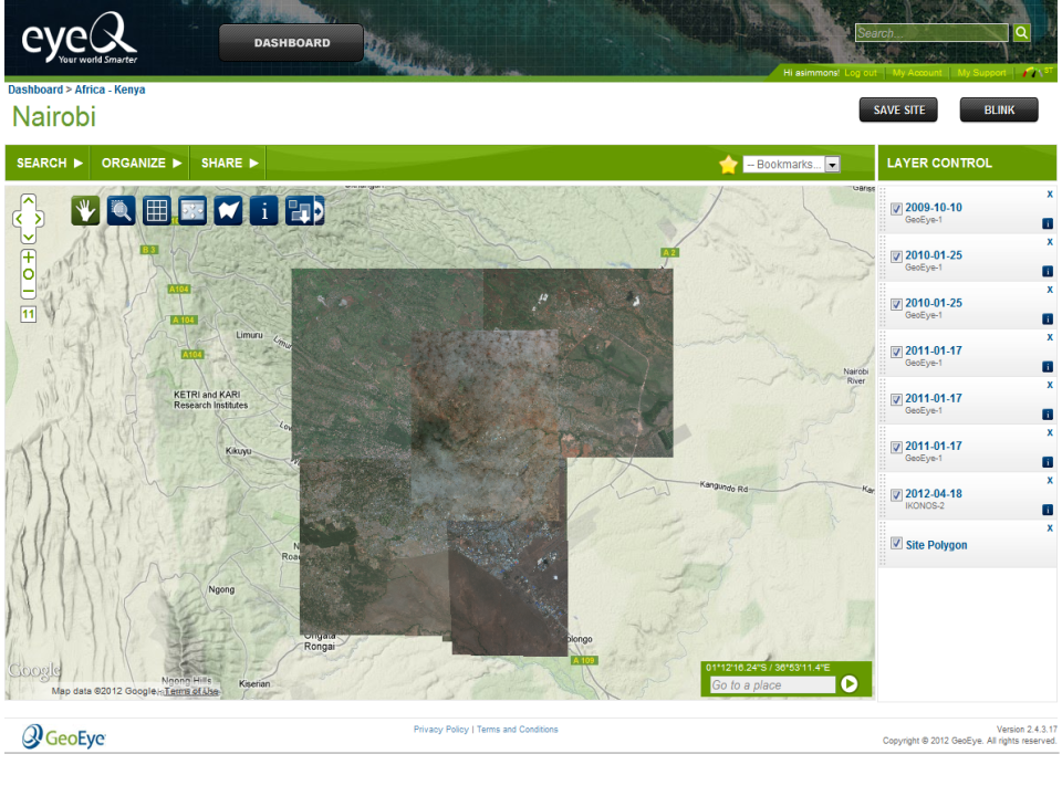
GeoEye's EyeQ Platform Interface
An original user interface brief for EyeQ, GeoEye's online imagery delivery system. Developed in conjunction with the Rapid Delivery of Online Geospatial-Intelligence (RDOG) initiative, platforms like EyeQ revolutionized how intelligence agencies accessed commercial data. Instead of waiting for physical media or bespoke downlinks, analysts could rapidly search, discover, and stream commercial satellite imagery directly to their desktops over secure web-based networks.
Key stakeholders in the EVWHS program include the primary commercial satellite imagery providers, most notably DigitalGlobe and GeoEye, which entered the EnhancedView era as independent competitors and the two principal U.S. high-resolution commercial imagery providers. In August 2010, NGA awarded major EnhancedView agreements to both companies. GeoEye's award carried a maximum potential value of approximately $3.8 billion, while DigitalGlobe's agreement carried a maximum potential value of approximately $3.55 billion. GeoEye also played a crucial role, with its EnhancedView Web Hosting Service evolving from the RDOG system to provide online access to its high-resolution imagery. The imagery provided through EVWHS includes high-resolution panchromatic imagery with resolutions of 32-50 cm and multispectral imagery with resolutions of 1.2-2 m. The program also incorporates imagery from other commercial vendors licensed by the US government, complementing the extensive archive from Maxar. The competitive landscape changed several years later when DigitalGlobe and GeoEye completed their merger in January 2013, consolidating the two major EnhancedView providers under the DigitalGlobe name. For the core U.S. government high-resolution commercial imagery market, the merger also sharply concentrated the supplier base, leaving a single dominant domestic provider until newer commercial constellations gradually began winning meaningful government business.
The public contract values also obscure how competitive the EnhancedView acquisition was internally. GeoEye received the larger maximum-value award and could therefore appear, from the outside, to have secured the stronger initial position. The companies also proposed materially different approaches to satisfying NGA's requirements. Former NGA acquisition executive Karyn Hayes-Ryan notes that, at the time, there was substantial internal debate over the competing strategies and senior-level involvement in determining how the final acquisition should be structured. Those deliberations are not fully visible in publicly available contract announcements, and the details of the internal acquisition process are therefore treated here as oral history rather than as part of the documentary record.
The EVWHS program has continuously evolved, incorporating advancements in commercial satellite technology. This includes the integration of imagery from advanced satellites like WorldView-3, launched in 2014, which offers improved resolution (down to 31 cm panchromatic) and enhanced spectral diversity, including multiple short-wave infrared bands capable of imaging through haze, fog, and smoke. The program emphasizes faster delivery of current imagery, with the goal of making newly collected imagery available online within hours of acquisition. This continuous evolution ensures that US government users have access to the most up-to-date and capable commercial satellite imagery to support their critical missions.
Commercial SAR: COMSAR and the Early Expansion Beyond Optical Imagery
The government's interest in commercially acquired remote sensing was already expanding beyond electro-optical imagery during the same period. On December 29, 2009, NGA awarded three indefinite-delivery, indefinite-quantity contracts under the Commercial Satellite Synthetic Aperture Radar, or COMSAR, program. The awards went to MDA Geospatial Services, EADS North America, and Lockheed Martin Space Systems, with each contract carrying a maximum value of approximately $85 million. COMSAR provided NGA and its customers with access to commercially available radar imagery, data products, and related services capable of supporting collection through darkness, clouds, and adverse weather.
COMSAR is historically important because it demonstrates that the government's move toward a multi-phenomenology commercial architecture began much earlier than the recent generation of U.S. commercial SAR constellations. Public NGA records from the following years describe COMSAR as an established mechanism for satisfying validated commercial radar requirements and reference efforts to improve tasking, processing, discovery, and dissemination of commercial SAR. The radar contracts of the 2020s therefore did not introduce the idea of commercial SAR augmentation; they represented a new generation and eventual operational maturation of an acquisition approach already being developed during the EnhancedView era.
Commercial imagery's value was not confined to combat operations. The same characteristics that made unclassified imagery useful to coalition forces—rapid acquisition, broad licensing, and ease of distribution—also made it particularly effective during domestic and international disasters. Eagle Vision systems were used during Hurricane Katrina in 2005, the 2010 Haiti earthquake, the 2011 earthquake and tsunami in Japan and the Fukushima disaster, as well as numerous floods, fires, hurricanes, and other emergencies. Commercial optical and radar imagery could be processed rapidly and distributed to organizations such as FEMA, USGS, state governments, military responders, and international partners.
These missions reinforced a broader institutional lesson. Commercial imagery did not need to outperform classified national systems to provide unique value. During a disaster, the ability to distribute an unclassified image immediately to a state emergency manager, transportation planner, foreign government, or humanitarian organization could matter more than maximizing spatial resolution. Radar imagery added another advantage by providing observations through clouds and during periods of poor weather, while repeated optical collections allowed responders to compare pre-event and post-event conditions. Commercial imagery consequently became part of an increasingly shared geospatial response infrastructure rather than solely an intelligence product.
Expanding the Scope: The Roles of USGS and NOAA
United States Geological Survey (USGS)
The United States Geological Survey (USGS) has played a significant role in the evaluation and utilization of commercial imagery for purposes extending beyond intelligence gathering, particularly in mapping, land management, and scientific research. The USGS Remote Sensing Technologies Project actively works to understand the capabilities and limitations of commercial satellite data from international sources, providing technical expertise and supporting the calibration and characterization of emerging digital imaging technologies. Furthermore, the USGS collaborates with the NGA and other federal agencies on the Joint Agency Commercial Imagery Evaluation (JACIE) Team. JACIE's purpose is to assess the quality and utility of commercial data, providing independent characterizations of image and image-derived products to the broader remote sensing community. The USGS leads the near-term remote sensing data requirements process on behalf of the Federal government, collecting the needs of various civilian agencies and facilitating resource leveraging. The USGS Earth Resources Observation and Science (EROS) Center serves as a central archive for commercial data purchases (CDP Imagery collection), ensuring its accessibility for future use. Historically, EROS was much more than just an archive center; it served as a robust research and training hub for the applications of remote sensing across multiple disciplines. EROS employed geologists, foresters, agriculturalists, land managers, and hydrologists, comprising both USGS employees and contractors. The facility conducted extensive training for US commercial and government agencies (such as the USDA and USGS) and offered an annual international training course to students from global agencies. Today, EROS continues to maintain a team of remote sensing scientists at the forefront of Earth observation science applications.
An equally consequential development occurred outside the national-security acquisition system. After decades in which the cost of Landsat imagery had restricted its use, the federal government adopted a fundamentally different data-distribution philosophy. In January 2008, USGS Associate Director for Geography Barbara Ryan and NASA Earth Science Division Director Michael Freilich approved a new Landsat distribution policy that ultimately made the U.S. Landsat archive available electronically at no charge. Free Landsat 7 distribution began in October 2008, followed shortly thereafter by the broader archive.
The response demonstrated how profoundly price had constrained the earlier market. At its peak before free access, roughly 25,000 Landsat products were being distributed annually. Within the first year of no-cost access, distribution exceeded one million scenes, and by March 2020 the archive had recorded its 100 millionth download. The free-data policy transformed remote sensing from a workflow in which researchers carefully purchased a few selected scenes into one where analysts could examine entire regions repeatedly across decades. That change helped enable large-scale change detection, time-series analysis, automated classification, cloud computing, machine learning, and eventually many of the analytic techniques that characterize modern Earth observation.
The Landsat experience reveals that the United States ultimately developed two successful but very different economic models for Earth observation. In one model, moderate-resolution government imagery became a public infrastructure resource: taxpayers funded the satellites and archive, while users received the data without transactional cost. In the other, privately owned high-resolution systems were sustained through a mixture of commercial demand and large government procurement contracts. These approaches were not contradictory. Together they expanded the overall geospatial ecosystem. Open Landsat data lowered barriers to research, education, algorithm development, and commercial applications, while privately operated commercial systems, with the U.S. government serving as a major anchor customer, pushed spatial resolution, revisit rates, responsiveness, and specialized collection capabilities.
The USGS Commercial Data Program further supports the use of commercial data by federal civilian agencies by collecting and providing query and report capabilities on their remote sensing requirements.
National Oceanic and Atmospheric Administration (NOAA)
The National Oceanic and Atmospheric Administration (NOAA) is also a key player in the realm of commercial satellite imagery. NOAA is involved in regulating commercial remote sensing activities through its Commercial Remote Sensing Regulatory Affairs (CRSRA) office, which ensures compliance with US laws and international obligations. CRSRA, housed within NOAA's Office of Space Commerce, is specifically responsible for regulating space-based commercial remote sensing, including companies providing imagery to the NRO.
Beyond regulation, NOAA is a significant user of commercial satellite imagery for various environmental monitoring and weather forecasting applications. To further this utilization, NOAA has established the Commercial Weather Data Pilot and Commercial Data Purchase programs, which aim to support the development of commercial markets for space-based weather data and integrate these data into operational forecasts. The NOAA Office of Space Commerce also plays a broader role by providing a U.S. Government-wide perspective on potential commercial space business and partnership arrangements. The Secretary of Commerce holds the statutory authority to license commercial remote sensing satellite operations, a responsibility that has been delegated to NOAA's CRSRA Office. Crucially, through this licensing power, NOAA manages the U.S. commercial resolution policy, legally dictating the maximum spatial resolution that commercial vendors are permitted to collect and sell on the open market.
The Evolution of the U.S. Resolution Policy
The Secretary of Commerce holds the statutory authority to license private remote-sensing space systems, a duty delegated to NOAA's Commercial Remote Sensing Regulatory Affairs (CRSRA) office. Through these operating licenses, NOAA legally dictates the maximum spatial clarity vendors are permitted to sell. This framework serves as the primary mechanism the government uses to balance the protection of national security with the promotion of American commercial aerospace dominance.
Breaking the 1-Meter Barrier
Following the 1992 Land Remote Sensing Policy Act, the Clinton administration's Presidential Decision Directive 23 (PDD-23) in 1994 set the initial regulatory benchmark at 1-meter resolution. For decades, 1-meter clarity had been considered a vital threshold for military intelligence, capable of distinguishing individual vehicles and aircraft. When Space Imaging's IKONOS satellite launched in 1999 and began selling 1-meter panchromatic images on the open market, it sent a geopolitical shockwave across the globe. It proved definitively that the commercial sector could rival the capabilities of early Cold War national systems.
The Half-Meter Race
By the early 2000s, foreign competitors—particularly in Europe—were developing their own advanced imaging satellites. Recognizing that maintaining a strict 1-meter cap would permanently disadvantage U.S. firms, the government relaxed the commercial limit to 0.5 meters (50 centimeters). This crucial policy shift aligned perfectly with the NGA's NextView program, giving companies like GeoEye and DigitalGlobe the regulatory green light to build the highly advanced GeoEye-1 and WorldView-1 and 2 satellites. It established a comfortable equilibrium: commercial vendors provided excellent half-meter data for broad mapping and unclassified sharing, while the NRO retained the absolute highest-resolution sensors for exquisite intelligence problems.
The 25-Centimeter Breakthrough
The policy faced its next major test in 2014 as DigitalGlobe prepared to launch WorldView-3, a massive satellite capable of capturing imagery at a stunning 0.31 meters. However, NOAA regulations still legally capped commercial sales at 0.5 meters, meaning the company would have to artificially degrade its own images before selling them to non-government customers. Arguing that foreign competitors were rapidly catching up, DigitalGlobe successfully petitioned the U.S. government to relax the limit to 0.25 meters (25 centimeters). This was a watershed moment, allowing civil users and commercial clients to see ground features as small as a laptop keyboard.
The Foreign Availability Overhaul
The most profound shift in resolution policy occurred in 2020 when the Department of Commerce completely overhauled NOAA's licensing framework. Acknowledging that space was becoming inherently global and commercialized, the new rules abandoned arbitrary, static resolution caps. Instead, systems were categorized into tiers based on "foreign availability." Under this new paradigm, if a foreign entity could legally collect and sell imagery of a certain resolution or phenomenology (such as advanced SAR or shortwave infrared), U.S. companies were automatically permitted to match it. This regulatory modernization effectively untethered the commercial industry from rigid ceilings, ensuring that American companies would never be regulated out of the global market so long as the technology already existed in the wild.
The Interagency Ecosystem: The Role of the Civil Applications Committee (CAC)
The landscape of commercial imagery utilization within the US government is shaped by a complex interplay of various organizations and agencies, each with distinct roles and responsibilities. The National Geospatial-Intelligence Agency (NGA) stands as a central figure, historically leading the procurement, analysis, and distribution of commercial satellite imagery to support the intelligence community and the Department of Defense. However, the exact division of responsibilities regarding who is in charge of acquiring and procuring commercial imagery has occasionally been a point of contention between NGA and NRO leadership. Currently, broad procurement authorities have shifted toward the National Reconnaissance Office (NRO), which manages the Electro-Optical Commercial Layer (EOCL) program, the current framework for US government procurement of commercial satellite imagery. Complementing this role, the United States Geological Survey (USGS) plays a vital part in evaluating and utilizing commercial imagery for mapping, land management, and scientific research, also co-leading the Joint Agency Commercial Imagery Evaluation (JACIE) Team and serving as an archive for commercial data. The National Oceanic and Atmospheric Administration (NOAA) is also a key player, involved in regulating commercial remote sensing activities through its Commercial Remote Sensing Regulatory Affairs (CRSRA) office and utilizing commercial imagery for environmental monitoring and weather forecasting. Furthermore, the National Reconnaissance Office (NRO) manages the Electro-Optical Commercial Layer (EOCL) program, representing the current framework for US government procurement of commercial satellite imagery. These agencies interact with a diverse range of commercial satellite imagery providers who have been instrumental in the evolution of this domain.
A significant, yet often less visible, entity in this network is the Civil Applications Committee (CAC), an interagency body that plays a crucial role in coordinating the US government's civil remote sensing activities. The CAC ensures that remote sensing data, including commercial imagery, is effectively leveraged for a wide array of civilian applications, extending beyond the traditional focus on intelligence gathering. This committee serves as a central point for maximizing the benefits of remote sensing technology across various civilian government functions, fostering efficiency and preventing redundancy in the utilization of these valuable resources.
The primary purpose of the CAC is to coordinate the US government's diverse civil remote sensing endeavors. Its mandate focuses on ensuring the effective utilization of remote sensing data, including the increasingly important role of commercial imagery, for essential civilian applications. These applications span a broad spectrum, encompassing environmental monitoring to track ecological changes, disaster response efforts to aid in immediate relief and long-term recovery, and the sustainable management of natural resources vital for the nation's well-being. The establishment and continued operation of the CAC indicate a governmental recognition that the capabilities offered by remote sensing, initially propelled by national security imperatives, hold substantial value for a multitude of civilian government responsibilities, representing a deliberate and organized effort to harness this technology for the broader public good.
The Civil Applications Committee is an interagency body, bringing together expertise and perspectives from various government entities. Key member agencies include the National Aeronautics and Space Administration (NASA), the United States Geological Survey (USGS), and the National Oceanic and Atmospheric Administration (NOAA), among others. This diverse membership underscores the holistic approach the US government takes towards civil remote sensing, ensuring that research advancements from NASA, application expertise from USGS, and regulatory considerations from NOAA are all integrated within a coordinated framework. The inclusion of representatives from different sectors of the government fosters a collaborative environment where specific knowledge and needs related to remote sensing can be shared and addressed collectively.
The interaction between the CAC and the NGA is significant, particularly in areas where the civil and intelligence applications of commercial imagery may converge. While the NGA's primary mission centers on providing geospatial intelligence for national security, the CAC potentially offers guidance and recommendations to the NGA regarding commercial imagery acquisition and utilization that could also serve broader governmental benefits. For instance, the CAC might advocate for specific data formats, enhanced accessibility measures, or adaptable licensing terms in NGA's commercial contracts, ensuring that the substantial government investments made through programs like EnhancedView can also support civilian agency requirements whenever feasible, thereby maximizing the overall utility of these resources without compromising critical security considerations.
Given the USGS's prominent role in evaluating and archiving commercial data for civilian applications, the relationship between the CAC and the USGS is particularly close. The USGS's leadership in the Joint Agency Commercial Imagery Evaluation (JACIE) Team, which includes participation from the NGA, NASA, NOAA, and other agencies, underscores the importance of ensuring that commercial imagery acquired by the government meets the stringent quality standards necessary for diverse scientific and civil applications. This collaborative effort reflects a mechanism for quality control and validation, overseen by the CAC's member agencies, to guarantee the suitability of commercial data for a wide range of governmental uses.
NOAA's involvement in the CAC is also noteworthy, considering its dual role in regulating commercial remote sensing activities through CRSRA and as a significant user of commercial satellite imagery for environmental monitoring and weather forecasting. NOAA's establishment of the Commercial Weather Data Pilot and Commercial Data Purchase programs further highlights its commitment to leveraging commercial capabilities. NOAA's presence within the CAC facilitates discussions on how commercial remote sensing can effectively support its mission objectives while adhering to relevant legal and policy frameworks. This interagency collaboration ensures a balance between promoting the growth of the commercial space sector and the responsible acquisition and application of its data for critical environmental purposes.
The relationship between the CAC and the NRO, particularly concerning the NRO's management of the EOCL program, indicates a broader understanding of the utility of commercial imagery across government functions. While the EOCL program's primary focus is on acquiring imagery for military users, it also aims to support domestic agencies in areas such as natural disaster monitoring, crop production assessment, and climate change studies. The CAC likely serves as a valuable forum for civilian agencies to communicate their specific requirements and needs to the NRO, ensuring that the government's commercial imagery procurements, even those managed by intelligence-focused agencies, can contribute to a wider range of critical civil applications.
The extent of the CAC's direct involvement in the development, implementation, or oversight of specific commercial imagery programs like ClearView, NextView, and EnhancedView/EOCL is less explicitly documented but can be inferred. The CAC's role likely operates at a higher policy level, focusing on the overarching framework and ensuring that these programs align with the collective needs of the civil government agencies represented within the committee. It is plausible that the CAC provided input regarding the types of data, the necessary resolution, and the required accessibility standards for civilian applications, which subsequently influenced the technical specifications and contractual terms of these programs managed primarily by the NGA and later the NRO.
By the early 2020s, commercial imagery had become far more than an intelligence-community procurement program. A 2022 Government Accountability Office review of ten federal civilian departments and agencies found that Agriculture, Commerce, Energy, Interior, and NASA maintained commercial satellite imagery contracts of their own. Their requirements included higher revisit rates, rapid tasking, specialized spatial resolution, and spectral capabilities outside the visible range.
More revealingly, eight of the ten civilian departments and agencies surveyed reported using commercial satellite imagery acquired through NRO and NGA channels, either through participation in the National System for Geospatial Intelligence or through access to NGA's hosted imagery services. Commercial imagery had therefore evolved into a form of shared federal geospatial infrastructure. A satellite collection purchased initially under a national-security architecture could support agricultural assessment, scientific research, environmental monitoring, energy analysis, emergency response, or other civilian requirements without each agency independently recreating the entire acquisition system.
This broader utilization helps explain why commercial imagery policy cannot be understood solely as an NGA or NRO story. Intelligence agencies may manage many of the largest acquisition vehicles, but the resulting data ecosystem serves a much wider federal community. The evolution of licensing, archive access, data standards, sharing agreements, and interagency coordination has consequently been almost as important as improvements in the satellites themselves.
Civil Applications Committee (CAC) – Purpose and Key Member Agencies
| Purpose | Key Member Agencies | Relationship to Commercial Imagery |
|---|---|---|
| Coordination of US government civil remote sensing activities. Ensuring effective utilization for civilian applications (environmental monitoring, disaster response, resource management). | NASA, USGS, NOAA, and other federal civil agencies. | Provides a forum for civilian agencies to articulate their needs for commercial imagery. May influence data specifications and accessibility in government contracts. Coordinates the evaluation of commercial data quality for civil applications. |
Shaping the Landscape: Key Policies, Legislation, and Executive Orders
The utilization of commercial imagery by the US government has been significantly influenced by key policies, legislation, and executive orders, including the Land Remote Sensing Policy Act of 1992 and the US Commercial Remote Sensing Space Policy (NSPD-27) of 2003. The Civil Applications Committee, representing the unified voice of numerous civilian agencies, likely played an important role in shaping these and other relevant policies concerning commercial remote sensing. By articulating the collective needs and priorities of its member agencies, the CAC would have provided valuable input to both the executive branch and Congress during the formulation and revision of policies aimed at promoting the effective and widespread use of commercial imagery for civil applications.
The historical context of the CAC's involvement reveals its evolving influence in relation to major policy shifts. The committee's role in advocating for the integration of commercial remote sensing into civilian government functions likely became more pronounced as the capabilities of commercial satellites advanced and the demand for diverse applications grew, particularly in the post-Cold War era and following events like 9/11, which highlighted the need for comprehensive geospatial information across various sectors. Understanding this historical progression provides a more comprehensive appreciation of the CAC's enduring impact on the policy landscape governing commercial remote sensing.
The Civil Applications Committee stands as a vital coordinating body within the US government, ensuring that the benefits of remote sensing technology extend beyond national security interests to serve a wide range of critical civilian applications. Through its interagency collaboration, the CAC fosters effective communication and coordination among key players such as the NGA, USGS, NOAA, and NRO, facilitating the utilization of commercial imagery for environmental protection, disaster response, resource management, and scientific research. The CAC's activities underscore the US government's commitment to maximizing the societal benefits derived from its investments in remote sensing capabilities. Furthermore, the committee's role in shaping relevant policies highlights its influence in advocating for the integration and responsible use of commercial remote sensing technologies for the public good, demonstrating a strategic and coordinated approach to leveraging these advancements for the broader benefit of the nation.
A Network of Players: Key Agencies and Commercial Partners
The history of commercial imagery in the US government involves a complex network of organizations and agencies. The National Geospatial-Intelligence Agency (NGA) has been central, leading in the acquisition, analysis, and distribution of commercial satellite imagery for intelligence purposes. The United States Geological Survey (USGS) has also played a significant role, particularly in the evaluation and utilization of commercial imagery for mapping, land management, and scientific research. The USGS collaborates with the NGA and other agencies on initiatives like the Joint Agency Commercial Imagery Evaluation (JACIE) Team to assess the quality and utility of commercial data. The National Oceanic and Atmospheric Administration (NOAA) is involved in regulating commercial remote sensing activities through its Commercial Remote Sensing Regulatory Affairs (CRSRA) office, ensuring compliance with US laws and international obligations. NOAA also utilizes commercial satellite imagery for various environmental monitoring and weather forecasting applications. The National Reconnaissance Office (NRO) is another key player, responsible for managing the Electro-Optical Commercial Layer (EOCL) program, which represents the current framework for US government procurement of commercial satellite imagery.
A diverse range of Commercial Satellite Imagery Providers have been instrumental in shaping this landscape. Key companies include WorldView Imaging Corporation, Space Imaging, OrbImage, DigitalGlobe (now Maxar Technologies), GeoEye, Planet Labs, BlackSky, Capella Space, and Ursa Space. The consolidation within the industry through mergers and acquisitions, such as DigitalGlobe's acquisition of GeoEye, reflects the evolving market and the importance of scale in serving government needs.
Beyond these primary entities, other US Government Agencies have also played important roles. NASA has been foundational in early satellite technology development and continues to evaluate commercial data for scientific purposes . NASA has been foundational in early satellite technology development and continues to evaluate commercial data for scientific purposes. Historically, NASA's Commercial Remote Sensing Program (CRSP) at Stennis Space Center supported industry partnerships, application demonstrations, and efforts to develop commercial remote-sensing markets during the formative years of the industry. The CIA conducted early assessments of commercial imagery's potential. The Department of Commerce oversees the licensing of commercial remote sensing operations. The Army Geospatial Center (AGC) utilizes commercial imagery acquired through NGA contracts.
Finally, international competition, such as the launch of France's SPOT satellite and the availability of Soviet imagery in the 1990s, served as an early catalyst; heavily influencing the US government's decision to aggressively foster its own domestic commercial imagery market.
Key U.S. Organizations & Roles in Commercial GEOINT
The Commercial GEOINT Ecosystem: U.S. commercial remote sensing evolved through overlapping intelligence, acquisition, scientific, regulatory, and civil institutions. NGA historically managed many of the foundational high-resolution commercial imagery programs, while NRO now leads major commercial remote-sensing acquisition across an increasingly diverse set of phenomenologies. NGA remains central to requirements, exploitation, dissemination, analytics, and integration. USGS, NOAA, and NASA provide civil, scientific, archival, regulatory, and historical market-development functions, while the Civil Applications Committee helps connect national-security capabilities with civilian government needs.
From Exquisite Images to Persistent Observation: The NewSpace Transition
The commercial imagery model established by ClearView, NextView, and EnhancedView was initially dominated by a small number of large satellites designed primarily around spatial resolution. Government requirements encouraged the development of increasingly capable spacecraft such as WorldView-1, GeoEye-1, and later WorldView-3, providing sub-meter imagery that in earlier decades would have been unimaginable outside national reconnaissance systems. By the early and mid-2010s, however, a second commercial revolution was underway. Improvements in small-satellite technology, electronics, launch availability, cloud computing, and venture financing allowed new companies to pursue a fundamentally different approach to Earth observation.
The emerging model did not necessarily attempt to outperform the largest commercial satellites in spatial resolution. Instead, companies began competing on temporal resolution—how frequently they could observe the same location. Large constellations of smaller satellites could image extensive portions of the planet repeatedly, making it possible to monitor activity rather than simply capture individual high-resolution scenes. The commercial value proposition gradually expanded from What does this location look like? toward What changed here since yesterday?
Scott Herman, who helped develop commercial imagery dissemination platforms during the RDOG and EnhancedView eras, describes the larger transformation as an expansion “from mapping to monitoring.” Higher revisit was essential, but revisit alone was not the endpoint. As commercial satellites could return to the same locations more frequently and delivery latency compressed from days toward hours and eventually minutes, the operating concept itself changed. Imagery could increasingly support continuing awareness of activity rather than simply creating or refreshing a map. That transition changed the value government placed on persistence, tasking responsiveness, dissemination, analytics, and automated detection.
Government acquisition mechanisms were beginning to change alongside the satellite market. In 2016, NGA and the General Services Administration implemented the Commercial Initiative to Buy Operationally Responsive GEOINT, or CIBORG, as a more flexible means of acquiring emerging commercial imagery, geospatial data, products, analytics, and services. Public documentation shows the initiative continuing into at least 2019, when GSA and NGA awarded Earth Observation Solutions blanket purchase agreements in support of CIBORG. The public record is less clear about how long CIBORG persisted as a distinct acquisition vehicle after that period. Its historical importance lies less in its longevity than in the acquisition problem it attempted to solve: a commercial marketplace that was becoming too diverse and fast-moving to be addressed solely through the long-duration structures developed during the NextView and EnhancedView eras.
Planet became one of the clearest demonstrations of this shift. NGA began using a Planet subscription in 2016, and in October 2019 NRO assumed responsibility for the subscription as part of the broader transition of commercial imagery acquisition from NGA to NRO. The contract provided daily, large-area imagery at approximately 3–5 meter resolution. Pete Muend emphasized the ability to observe country- or even continent-scale areas every day, while NGA's David Gauthier described the capability as part of an analytic transformation that was moving NGA's attention “less on pixels and more on information content and services.”
That change represented more than the arrival of another imagery supplier. It expanded the criteria by which commercial imagery was valued. Spatial resolution remained critical for identification and detailed analysis, but revisit frequency, geographic persistence, collection capacity, latency, accessibility, and the ability to feed automated analytic systems became increasingly important. A lower-resolution image collected every day could answer questions that an exquisite image collected infrequently could not.
The commercial market was also becoming inseparable from cloud computing and analytics. Rather than delivering imagery as isolated files or physical products, providers increasingly exposed large archives through online platforms, APIs, subscription services, and machine-to-machine interfaces. This made it possible for automated systems to search enormous image volumes, detect changes, classify objects, and alert analysts to activity. Commercial GEOINT therefore began shifting from a business centered primarily on the sale of satellite scenes toward one involving persistent data streams and derived information services.
This transformation helps explain the institutional shift between NGA and NRO during the late 2010s. NRO increasingly became the central acquirer of commercial overhead data, while NGA expanded its attention toward integration, exploitation, analytic services, and the broader commercial GEOINT marketplace. It also explains why EOCL would differ conceptually from the earlier EnhancedView model. By 2022, the government was not merely purchasing very-high-resolution photographs from a small number of providers. It was constructing a commercial layer designed to combine different resolutions, revisit rates, collection models, licensing structures, and ultimately different sensing phenomenologies within the national architecture.
The Next Phase: Electro-Optical Commercial Layer (EOCL) Program
The EnhancedView program, while highly successful, has been succeeded by a new generation of initiatives designed to further leverage the advancements and diversification within the commercial satellite imagery market. The primary follow-on program is the Electro-Optical Commercial Layer (EOCL) program, managed by the National Reconnaissance Office (NRO) in partnership with the NGA and the US Space Force.
The EOCL program represents a significant shift in the government's approach to acquiring commercial imagery. Instead of relying on a few large providers with bespoke contracts, EOCL aims to tap into the capabilities of a broader range of commercial vendors, including those operating smaller, more agile satellite constellations and offering innovative data products and services. This approach is intended to increase the resilience of the government's imagery supply, foster competition within the commercial sector, and provide access to a more diverse set of data and analytic capabilities.
Ukraine: The Strategic Proof Point for the Mature Commercial Architecture
Russia's full-scale invasion of Ukraine in February 2022 provided perhaps the clearest demonstration to date that commercial remote sensing had become an integral component of modern national security. Commercial optical and radar providers documented Russian force concentrations before the invasion, monitored troop movements and infrastructure damage during the conflict, and supplied imagery that could be shared among U.S. agencies, allied governments, military partners, journalists, humanitarian organizations, and the broader public. GAO subsequently cited the war in Ukraine as a prominent example of the growing national-security importance of commercial satellite imagery.
Ukraine also revealed how radically the information environment had changed since the early commercial imagery era. In Afghanistan in 2001, the U.S. government had been able to purchase exclusive access to the only domestic one-meter commercial satellite imagery of the operational area. By 2022, commercial Earth observation involved numerous optical, radar, and radio-frequency providers operating internationally, making comprehensive control of battlefield visibility far more difficult. Commercial imagery could simultaneously serve government intelligence requirements and enable independent public scrutiny of a major war.
The conflict reinforced several arguments that had accumulated over previous decades: commercial imagery provided additional capacity beyond national systems; its unclassified character made rapid sharing with allies possible; diversified commercial constellations offered resilience; and different phenomenologies could provide complementary information. These lessons formed part of the strategic environment in which NRO moved ahead with the largest commercial imagery awards in its history.
The NRO awarded multiple contracts under the EOCL program in 2022, with a total potential value exceeding $9 billion over ten years. These contracts were awarded to several companies, including Maxar Technologies, Planet Labs, and BlackSky Technology. This multi-vendor approach signifies a move away from the previous model of primarily relying on Maxar (formerly DigitalGlobe and GeoEye) for the bulk of high-resolution commercial imagery.
The current US government commercial imagery program under EOCL can be characterized by the following key features:
Diversified Vendor Portfolio: The government now contracts with a wider array of commercial imagery providers, offering different types of imagery (e.g., very high-resolution, medium-resolution, frequent revisit) and analytical services.
Focus on Agility and Responsiveness: The inclusion of companies with large constellations of small satellites emphasizes rapid revisit rates and the ability to quickly task and collect imagery over areas of interest.
Integration of New Technologies: The program aims to incorporate emerging technologies and data sources from the commercial sector, such as synthetic aperture radar (SAR) and other non-traditional imagery.
Emphasis on Data Analytics and Services: Beyond just raw imagery, the government is increasingly interested in acquiring value-added services, including advanced analytics, change detection, and 3D modeling derived from commercial data.
Collaborative Approach: The EOCL program is a collaborative effort between the NRO, NGA, and US Space Force, reflecting a unified government strategy for commercial imagery acquisition.
While the EVWHS platform provided a centralized access point for imagery primarily from Maxar under the EnhancedView program, the current landscape under EOCL is likely to involve a more distributed architecture, potentially with different access mechanisms for different vendors and data types. The NGA continues to play a crucial role in disseminating and utilizing commercial imagery acquired through the EOCL program to support the intelligence community and other government users. RDOG's emphasis on rapid delivery remains relevant in the current context, and its capabilities are likely integrated into the broader framework of accessing and distributing commercial imagery from multiple EOCL vendors. BlackSky was awarded an extension to its EOCL contract in January 2025, securing services until mid-2026 and including upgrades to imagery search and task management.
Evolution of NGA/NRO Commercial Imagery & GEOINT Programs and Delivery Capabilities
| Program / Capability | Years Active | Key Objectives | Primary Providers / Participants |
|---|---|---|---|
| ClearView | 2003 – 2004 | Establish sustained government purchasing of high-resolution commercial satellite imagery and provide predictable federal demand to the emerging U.S. commercial imagery industry. | DigitalGlobe, Space Imaging, ORBIMAGE |
| NextView | 2003 – 2009 | Secure priority access to higher-resolution commercial imagery while using long-term government commitments and development support to help finance and sustain the next generation of commercial imaging satellites. | DigitalGlobe and ORBIMAGE / GeoEye |
| RDOG | 2009 – EnhancedView Era | Provide rapid web-based dissemination of newly collected commercial imagery, initially emphasizing delivery within approximately 24 hours. RDOG helped move commercial GEOINT from file-ordering and specialized delivery workflows toward routine online discovery, viewing, streaming, and distribution. | DigitalGlobe initially; related provider-managed web-delivery capabilities later expanded through the EnhancedView / EVWHS environment |
| COMSAR | 2009 – 2014* | Establish a dedicated acquisition pathway for commercial Synthetic Aperture Radar (SAR) imagery, data products, and direct-downlink services, providing all-weather and day/night commercial sensing alongside electro-optical imagery. | MDA Geospatial Services, EADS North America, Lockheed Martin Space Systems |
| EnhancedView | 2010 – 2022 | Scale government access to very-high-resolution commercial imagery through major long-term acquisition commitments, priority tasking, broad licensing, large imagery volumes, and increasingly web-based dissemination. | GeoEye and DigitalGlobe; the companies later consolidated under DigitalGlobe and subsequently Maxar |
| CIBORG | 2016 – at least 2019** | Create a centralized and flexible acquisition pathway for emerging commercial GEOINT imagery, geospatial data, products, analytical capabilities, and services in response to a rapidly changing commercial marketplace and evolving government mission requirements. | NGA and GSA acquisition partnership; multiple commercial GEOINT providers |
| EnhancedView Follow-On (EVFO) | 2018 – 2022 | Transition principal commercial imagery acquisition responsibility from NGA to NRO while sustaining access to established high-resolution commercial capabilities pending the next generation of acquisition programs. | DigitalGlobe / Maxar |
| EOCL | 2022 – Present | Institutionalize a diversified electro-optical commercial layer within the national architecture, combining very-high-resolution imagery, high-revisit collection, broader capacity, standardized licensing, and multiple commercial providers. | BlackSky, Maxar, Planet |
* COMSAR: The December 2009 IDIQ awards included a five-year ordering period. Program dates describe the principal publicly documented acquisition period and should not necessarily be interpreted as the end of government use of the underlying commercial radar capability.
RDOG: RDOG is included because of its operational significance in the evolution of commercial GEOINT delivery. Unlike ClearView, NextView, EnhancedView, and EOCL, it functioned primarily as a dissemination and service capability rather than a top-level imagery acquisition program.
** CIBORG: Public sources document implementation beginning in 2016 and Earth Observation Solutions blanket purchase agreements supporting the initiative in 2019. The public record reviewed for this article does not establish continuous operation of CIBORG as a distinct acquisition vehicle through the present.
Beyond Electro-Optical: From Commercial Imagery to Commercial Sensing

For most of the history described in this report, “commercial imagery” primarily meant electro-optical satellite photographs. By the late 2010s, however, the commercial marketplace was expanding into sensing phenomenologies capable of answering questions that traditional optical imagery could not. Synthetic aperture radar could collect through clouds and darkness; radio-frequency sensing could identify and geolocate emitters; hyperspectral systems promised information about materials and chemical composition; and increasingly capable thermal-infrared systems could reveal heat signatures associated with industrial activity, infrastructure use, and other processes invisible to conventional optical imagery. The logical endpoint of the commercial imagery strategy was therefore no longer simply the acquisition of more photographs. It was the creation of a multi-phenomenology commercial sensing layer.
The modern expansion into new U.S. commercial sensing constellations built upon earlier government experience with non-optical commercial sources, including NGA's COMSAR program. In December 2019, NRO awarded a new generation of commercial integration-study contracts to Capella Space for synthetic aperture radar and HawkEye 360 for radio-frequency remote sensing. NRO described the contracts as part of an effort to understand how emerging commercial sources could be integrated into an architecture combining national and commercial capabilities. The studies joined other commercial evaluations involving BlackSky, HySpecIQ, Maxar, and Planet and and represented a new generation of NRO efforts to integrate emerging U.S. commercial SAR, RF, and other non-optical capabilities into the national architecture.

The NRO subsequently created its Strategic Commercial Enhancements Broad Agency Announcement framework to provide a more systematic pathway for emerging capabilities. Commercial radar became an early focus, followed by radio frequency and hyperspectral imaging. In September 2022, NRO awarded commercial RF study contracts to six providers and explicitly noted the value of shareable commercial data for intelligence cooperation and humanitarian missions. The agency continued parallel evaluation efforts for radar and hyperspectral sensing, creating a structured progression from market exploration toward operational use.
By 2026, that progression had begun crossing an important threshold. On August 5, 2026, NRO announced three operational Radar Commercial Augmentation contracts supporting intelligence analysis, global discovery and monitoring, disaster response, humanitarian assistance, and other requirements through day-and-night, all-weather SAR imagery. The selected providers were Capella Space, ICEYE US, and Umbra, each of which had progressed through the earlier commercial radar evaluation process.
Only twelve days later, on August 17, 2026, NRO announced an operational Commercial Radio Frequency Capabilities Augmentation contract with HawkEye 360. The award followed several years of commercial RF evaluation and moved the capability from study and demonstration toward operational augmentation of government systems.
These developments reveal a larger pattern in the history of government-commercial integration. The acquisition pathway pioneered with optical imagery is increasingly being applied to new phenomenologies:
identify an emerging commercial capability → evaluate it through studies and demonstrations → validate its operational utility → establish sustained augmentation contracts → integrate it into the larger national architecture.
The historical significance is considerable. ClearView and NextView were created largely to ensure government access to high-resolution commercial photographs. The modern architecture is evolving toward something broader: a distributed commercial intelligence layer in which optical imagery, radar, radio-frequency sensing, hyperspectral data, and future modalities can complement national systems according to mission need. Commercialization has therefore moved beyond the imagery industry that originally inspired these programs and into the wider architecture of remote sensing itself.
The Policy Pendulum: Openness, Control, and National Security
The history of American commercial remote sensing has always contained a fundamental contradiction. The United States has repeatedly sought to create the world's most capable private Earth-observation industry while simultaneously confronting the national-security consequences of making increasingly sophisticated information about the planet commercially available. Policy has consequently oscillated between two objectives: promoting U.S. commercial leadership and preserving the government's ability to restrict sensitive collection or dissemination.
During the early remote-sensing era, the government could maintain stringent controls because very few entities possessed satellite imaging systems. The emergence of foreign capabilities gradually undermined that approach. France's SPOT system, commercially available Soviet imagery, and later increasingly capable international remote-sensing satellites demonstrated that restricting American companies could not necessarily prevent the underlying information from becoming available. Instead, excessive domestic restrictions risked transferring customers, investment, and technological leadership to foreign competitors. This realization was a major factor behind the policy liberalization of the 1990s and has remained a recurring consideration ever since.
Yet liberalization never meant the abandonment of national-security controls. The 1994 policy framework retained the concept commonly known as shutter control, under which the U.S. government could restrict commercial collection or dissemination during national-security emergencies. The Afghanistan war illustrated the issue vividly. Rather than formally shutting down the IKONOS system, NIMA purchased exclusive rights to imagery over the operational area, achieving many of the same effects through an assured-access contract. The episode demonstrated both the military utility of commercial imagery and the government's concern that the same imagery might be available to adversaries, news organizations, or other outside users.
As the number and capability of foreign systems increased, however, unilateral restrictions on U.S. companies became progressively harder to justify. Commerce's major 2020 revision of 15 CFR Part 960 explicitly recognized this change. The new licensing framework categorized commercial systems partly according to whether substantially similar data were already available from sources outside U.S. regulatory control. Systems producing data comparable to that available internationally could receive much lighter regulatory treatment. Commerce explained that restricting a U.S. capability while an equivalent or superior foreign capability was commercially available could disadvantage American companies without meaningfully protecting national security.
This represented a profound shift in regulatory philosophy. Earlier policy often began with the assumption that advanced remote-sensing capability itself should be controlled. The modern framework increasingly asks whether that capability can realistically still be controlled at all. Once equivalent information is readily available from foreign or commercial sources beyond U.S. jurisdiction, restricting only American providers may simply shift demand abroad. International competition therefore became not merely an economic concern but a limiting factor on the government's ability to regulate geospatial transparency.
The proliferation of commercial systems has made this tension even sharper. The same properties that make commercial imagery strategically valuable—its unclassified nature, broad availability, rapid dissemination, and ability to support allies—also make it difficult to contain. The contrast between Afghanistan in 2001 and Ukraine in 2022 illustrates this transformation. At the beginning of Operation Enduring Freedom, a single assured-access contract could substantially control domestic high-resolution commercial coverage of the battlefield. Two decades later, a major conflict was being observed by numerous optical, radar, and radio-frequency satellite operators, while commercial data were consumed not only by governments but by journalists, researchers, humanitarian groups, companies, and open-source intelligence communities.
The regulatory challenge therefore has not disappeared; it has evolved. Governments may still impose temporary collection restrictions, managed-access policies, contractual limitations, or other controls during crises. At the same time, increasingly global commercial competition means that restricting domestic providers can carry strategic costs of its own. If U.S. companies are prevented from offering capabilities that foreign competitors can sell freely, customers, investment, technical expertise, and ultimately market leadership may migrate outside the United States.
This is the context in which the contemporary debate over commercial satellite transparency should be understood. It is not a new conflict created by today's constellations. It is the latest version of a policy question that has accompanied U.S. remote sensing from its earliest commercial era:
“How does a nation encourage an industry powerful enough to strengthen national security without making that same capability impossible to control when national-security interests demand secrecy?”
There is no permanent technical solution to that question because the underlying market continues to change. Each increase in commercial resolution, revisit, phenomenology, automation, and international availability shifts the balance again. The history of American commercial remote sensing is therefore not simply a steady progression toward greater openness. It is a continuing negotiation between transparency, economic competitiveness, allied sharing, intelligence utility, and control.
The Human Element: Leaders Behind the Government's Adoption of Commercial Imagery
People Behind the Evolution Selected leaders, policymakers, scientists, entrepreneurs, and acquisition professionals
Reconnaissance & Earth Observation Pioneers
Established the technological and institutional foundations of overhead reconnaissance. CORONA proved the strategic value of observing large areas from orbit, while the emerging civil Earth-observation community expanded remote sensing into agriculture, science, mapping, and resource monitoring.
Civil, Policy & Commercial Market Builders
Helped move U.S. remote sensing from government-operated systems toward regulated commercial participation. The 1984 commercialization experiment, EOSAT's efforts to build a global Landsat market, the 1992 policy correction, and entrepreneurs pursuing privately operated high-resolution satellites established the commercial foundation that followed.
Operational Adoption & Technical Validation
Helped move commercial imagery from an experimental supplement into an operational GEOINT resource. NIMA and NGA expanded government purchasing through ClearView and NextView while JACIE scientists independently characterized commercial sensors and built confidence in their accuracy, reliability, and mission utility.
EnhancedView, RDOG & Acquisition Architects
Worked across acquisition, requirements, funding, technical architecture, and interagency coordination as commercial imagery scaled dramatically. Their era included RDOG, COMSAR, EnhancedView, web-based dissemination, and the transition from individual imagery purchases toward persistent mission access, structured observations, and increasingly sophisticated commercial GEOINT workflows.
Persistent GEOINT & Multi-Phenomenology Integration
Advanced the modern commercial architecture through Planet subscriptions, CIBORG, the transfer of principal imagery acquisition responsibility to NRO, EOCL, commercial analytics, and the expansion into SAR, RF, hyperspectral, infrared, and other sensing phenomenologies. The focus increasingly shifted from purchasing individual images toward persistent data, analytics, services, and integrated commercial sensing.
The rise of commercial satellite imagery within the United States Government was not simply the result of better sensors, cheaper launch vehicles, or improved computing. It was the product of several generations of policymakers, intelligence officials, scientists, entrepreneurs, acquisition professionals, and operational users who gradually changed how the government thought about observing the Earth from space. Their contributions were not identical. Some created the technological and institutional foundations of overhead reconnaissance; others opened the regulatory environment to private companies; still others demonstrated that commercial imagery could satisfy real intelligence requirements and then built the procurement mechanisms necessary to make it a routine component of the national architecture.
The lineage begins with the early national reconnaissance programs of the Cold War. Although systems such as CORONA were classified government programs rather than commercial remote sensing, they established much of the technological, organizational, and analytical heritage from which the later industry developed. President Dwight D. Eisenhower approved CORONA in February 1958 and continued supporting the effort through an extraordinary series of early failures. Richard M. Bissell Jr. of the Central Intelligence Agency and Air Force Brig. Gen. Osmond J. Ritland provided the joint government leadership that allowed the highly experimental program to survive, while teams distributed across the CIA, Air Force, Lockheed, Itek, General Electric, and other organizations transformed the concept of satellite reconnaissance into an operational capability. After twelve unsuccessful missions, the successful recovery of Discoverer 13 and the imagery returned by Discoverer 14 in 1960 demonstrated that persistent observation of vast areas from orbit was possible. The resulting intelligence helped resolve major uncertainties about Soviet strategic capabilities, including the feared "missile gap."
The significance of this heritage to the commercial imagery story is not that CORONA itself was commercial, but that it established an enduring government understanding of the value of overhead observation. Over the following decades, civil programs such as Landsat broadened that understanding beyond military reconnaissance by demonstrating the utility of remotely sensed data for agriculture, geology, resource management, environmental monitoring, mapping, and scientific research. By the 1980s, policymakers were increasingly confronted with a new question: if Earth observation had value across so many sectors, did the government itself need to own and operate every system that provided it?
Congress began addressing that question with the Land Remote Sensing Commercialization Act of 1984. The legislation attempted to encourage private involvement in land remote sensing and, importantly, authorized the Department of Commerce to license private remote-sensing space systems. The effort to commercialize Landsat itself proved problematic, particularly because the market for expensive satellite data was not yet mature, but the legislation established an important principle: privately owned Earth-observation satellites could operate within a U.S. regulatory framework.
A second generation of policymakers strengthened that framework at the end of the Cold War. Representative George E. Brown Jr. of California became an important congressional figure in this transition, sponsoring the legislation that became the Land Remote Sensing Policy Act of 1992. Signed by President George H. W. Bush on October 28, 1992, the law replaced the earlier 1984 framework while maintaining private-system licensing and reducing some of the barriers facing commercial remote sensing. In his signing statement, Bush specifically emphasized the law's intention to encourage commercial opportunities by supporting investment, streamlining licensing, reducing unnecessary restrictions on privately collected data, and fostering a larger market for remote-sensing products.
The policy opening quickly attracted entrepreneurs willing to accept the extraordinary technical and financial risks of building privately operated high-resolution imaging satellites. One of the most consequential was Dr. Walter Scott, who founded WorldView Imaging Corporation in 1992. The company subsequently became EarthWatch and then DigitalGlobe. WorldView received the first U.S. license for a high-resolution commercial remote-sensing satellite under the new policy environment. Scott later described the 1992 legislation as the framework that allowed commercial Earth observation to emerge as a viable public-private partnership. His experience illustrates an important part of the commercial imagery story: government policy could permit an industry to exist, but private capital, engineering talent, and entrepreneurial persistence were still required to make that industry real.
The Clinton administration accelerated this shift in March 1994 through Presidential Decision Directive 23, which established a new U.S. policy governing foreign access to remote-sensing capabilities. The policy reflected a fundamental recognition that advanced remote sensing was becoming internationally available and that attempting to preserve U.S. advantages primarily by suppressing domestic commercial capabilities risked weakening American industry instead. PDD-23 sought to balance national security concerns with the competitiveness of U.S. remote-sensing companies, helping establish the environment in which firms such as Space Imaging, EarthWatch/DigitalGlobe, and OrbImage could pursue increasingly capable commercial systems.
By the late 1990s and early 2000s, however, simply allowing commercial satellites to exist was no longer the central challenge. The harder problem was persuading the national-security establishment to use their products routinely. Within the newly established National Imagery and Mapping Agency (NIMA), officials increasingly argued that commercial imagery could relieve pressure on classified national systems, provide unclassified products that could be shared more easily with allies and civil agencies, and satisfy many routine collection requirements at lower cost. Early advocates within NIMA, including Deputy Director for Corporate Affairs W. Douglas "Doug" Smith, publicly pushed for greater government use and funding of commercial imagery at a time when the industry remained financially fragile and operational adoption was far from assured.
The most consequential agency leader during this transition was Lt. Gen. James R. Clapper Jr., who became director of NIMA in 2001. Under Clapper, commercial imagery moved much closer to the center of the agency's operating model. In early 2003, as NIMA implemented the ClearView contracts, Clapper described that fiscal year as the first time the agency was receiving "serious money" for commercial satellite imagery. Contemporary accounts document a major increase in spending and Clapper's preference for obtaining suitable capabilities from commercial providers rather than recreating them unnecessarily inside government. He also emphasized two advantages that would become recurring themes in U.S. commercial imagery policy: commercial collection could absorb routine requirements that otherwise competed for scarce national assets, and its unclassified nature made imagery substantially easier to share with coalition partners. ClearView and the subsequent NextView program therefore represented more than procurement contracts; they marked the beginning of commercial imagery becoming an intentional component of the national GEOINT architecture.
This institutional shift was reinforced at the presidential level. In April 2003, President George W. Bush authorized a new U.S. Commercial Remote Sensing Space Policy. Its language was unusually explicit: the United States Government would rely "to the maximum practical extent" on U.S. commercial remote-sensing capabilities to satisfy military, intelligence, foreign-policy, homeland-security, and civil requirements, while reserving government-owned systems primarily for needs that commercial providers could not effectively meet. The policy also called for a long-term, sustainable relationship between the federal government and the domestic commercial remote-sensing industry. That principle closely matched the acquisition strategy unfolding through ClearView and NextView, where government contracts not only purchased imagery but also helped provide the predictable demand necessary for companies to finance and deploy increasingly capable satellites.
Technical acceptance was just as important as policy and procurement. Analysts and mission planners had to trust that commercially produced data were geometrically accurate, radiometrically reliable, and sufficiently characterized for demanding government applications. The Joint Agency Commercial Imagery Evaluation, or JACIE, partnership emerged in 2001 to address precisely this problem. Drawing expertise from the USGS, NASA, NIMA/NGA, USDA, and leading academic partners like the Rochester Institute of Technology's Chester F. Carlson Center for Imaging Science, JACIE created an independent, interagency mechanism for evaluating commercial remote-sensing systems and communicating their performance to the broader user community. Early participants included specialists such as Vicki Zanoni, along with NIMA and USGS scientists assessing IKONOS and later commercial systems. Over time, contributors including Jon Christopherson, alongside RIT's imaging scientists and many other calibration and validation specialists, helped institutionalize methods for understanding commercial sensor performance. Their work was less visible than major contract announcements, but it performed an essential function: converting commercial imagery from an unfamiliar outside product into data that government scientists, analysts, and operators could evaluate with confidence.
Commercial companies simultaneously had to demonstrate that they could deliver reliable operational capability rather than simply impressive imagery. Space Imaging's IKONOS, launched in 1999, became an early proof point for one-meter-class commercial imaging. CEO John Copple publicly emphasized two characteristics that made commercial systems increasingly attractive to NIMA: the government could obtain imagery without having to build another satellite, and the resulting unclassified information could be shared more readily with allies. Companies including Space Imaging, DigitalGlobe, OrbImage, and later GeoEye competed aggressively for government business, and that competition pushed the industry toward higher resolution, greater collection capacity, faster delivery, and increasingly sophisticated ground infrastructure.
The transition from NextView into EnhancedView also depended on a less visible group of acquisition officials, technical specialists, and senior Defense Department advocates. Karyn Hayes-Ryan, William (Bill) Young, Keith Barber, Winston Beauchamp, Ed Walser, and others worked across requirements, acquisition, technical architecture, and commercial integration during this period. Hayes-Ryan specifically identifies Keith Barber and Winston Beauchamp as early contributors to analytical work conducted with NRO before EnhancedView existed as a formal acquisition program, helping examine how commercial capabilities might be incorporated more deeply into the national imagery architecture. Their work occurred before EnhancedView had fully emerged as a named acquisition program, illustrating that the eventual procurement grew out of years of analysis, institutional debate, and experimentation rather than appearing fully formed in 2010.
At the Department of Defense level, Frank Kendall became particularly important during the final EnhancedView acquisition period. Kendall became Principal Deputy Under Secretary of Defense for Acquisition, Technology and Logistics in March 2010. Hayes-Ryan recalls Kendall as personally instrumental in resolving funding issues surrounding EnhancedView and helping the acquisition move toward award. She also identifies Kevin Meiners as an important coordinator across the Department of Defense and Intelligence Community during the process. Their roles illustrate a recurring feature of the commercial imagery story: major acquisition programs often depended as much on budget alignment, interagency coordination, and persistence inside the bureaucracy as they did on satellite technology itself. Their work laid the foundation for the EnhancedView era, which carried that model into a much larger and more stable form. Shortly after becoming NGA director in 2006, Murrett publicly stated that the agency was determined to work closely with commercial imagery vendors and expected the sector to grow substantially. His tenure encompassed the maturation of NextView and the development of the strategy that would become EnhancedView. In April 2009, Director of National Intelligence Dennis Blair announced a broader imagery architecture that paired continued investment in highly capable national systems with substantially greater reliance on commercial imagery. The decision reinforced a principle that had gradually emerged over the previous decade: national and commercial satellites were not competing alternatives but complementary components of a larger collection architecture.
The EnhancedView era carried that model into a much larger and more stable form. Government commitments to DigitalGlobe and GeoEye supported the deployment and operation of increasingly capable commercial satellites while giving national-security users priority access to enormous volumes of unclassified high-resolution imagery. NGA Director Letitia Long subsequently inherited an environment in which commercial imagery was no longer an experimental augmentation. It had become an established component of GEOINT operations, dissemination, coalition information sharing, and the broader architecture through which NGA satisfied customer requirements.
A major institutional transition occurred in 2018 when EnhancedView commercial imagery acquisition responsibility formally shifted from NGA to the National Reconnaissance Office. The change clarified an emerging division of responsibilities: NRO would increasingly serve as the principal acquirer of commercial overhead imagery, while NGA would concentrate on requirements, analysis, integration, dissemination, and the growing market for commercial GEOINT data products and analytic services. Director Robert Cardillo described the transition as an opportunity for the GEOINT enterprise to take greater advantage not only of satellite pixels but also of commercial analytics and emerging services.
Two officials became particularly important in implementing that new model: Pete Muend, director of the NRO Commercial Systems Program Office, and David Gauthier, who led commercial operations at NGA. Their collaboration helped define the practical relationship between the two agencies. Muend described NRO as the principal acquirer of commercial imagery, while Gauthier emphasized NGA's increasing focus on extracting information, analytics, and other GEOINT services from the expanding commercial market. The 2019 transfer of the government's Planet imagery subscription from NGA to NRO illustrated this evolving arrangement and demonstrated that commercial value was no longer measured solely by spatial resolution. Daily global-scale revisit, analytics, radio-frequency geolocation, synthetic aperture radar, and other forms of commercially generated information were becoming part of a much broader GEOINT ecosystem.
That evolution culminated in the Electro-Optical Commercial Layer. Under NRO Director Dr. Christopher Scolese, with Muend's Commercial Systems Program Office leading the acquisition and NGA helping consolidate GEOINT community requirements, NRO awarded EOCL contracts to Maxar, Planet, and BlackSky in May 2022. The contracts represented the largest commercial imagery acquisition effort in NRO history and institutionalized a diversified commercial layer within the national architecture. Scolese summarized the underlying philosophy as "buy what we can, build what we must": commercial systems should satisfy requirements wherever they can do so effectively, allowing exquisite national systems to concentrate on the most difficult and sensitive intelligence problems. Muend similarly emphasized EOCL's ability to meet more customer requirements quickly while providing highly shareable imagery under standardized licensing arrangements.
Seen across this longer history, no single official, scientist, entrepreneur, or company can reasonably be credited with "creating" the government's commercial imagery capability, and there is no way we can include them all here. The transformation was cumulative. Eisenhower-era reconnaissance pioneers demonstrated the strategic power of overhead observation. Civil remote-sensing scientists broadened its applications. Congress and successive presidential administrations created a regulatory environment in which private systems could emerge. Entrepreneurs such as Walter Scott and the teams behind Space Imaging, DigitalGlobe, GeoEye, OrbImage, and their successors accepted enormous financial and technical risks to build those systems. Clapper and other NGA leaders converted commercial imagery from an occasional supplement into an operational resource. JACIE scientists helped establish confidence in the data. Murrett, Long, Cardillo, Gauthier, Muend, Sapp, Scolese, and many less visible acquisition officers, engineers, analysts, contracting specialists, and operators carried that partnership forward.
Their collective legacy is the modern commercial GEOINT architecture: an environment in which government-owned and privately operated systems increasingly function as parts of the same larger ecosystem. Commercial imagery has moved from something the intelligence community once debated whether it could trust or afford to use, to a capability the United States deliberately incorporates into collection planning, intelligence sharing, military operations, disaster response, scientific research, and strategic competition. The most important human achievement was therefore not any single satellite or contract. It was the gradual institutional acceptance of the idea that national advantage could be strengthened, not diminished, by allowing government and commercial capabilities to develop together.
The Broader Impact: Growth of the Geospatial Industry and NASA's CRSP Role
The US government's sustained and increasing utilization of commercial satellite imagery has had a profound and multifaceted impact on the growth and development of the geospatial industry as a whole. Major government procurement programs such as ClearView, NextView, and EnhancedView have acted as significant catalysts, providing substantial financial investment and a stable demand for commercial imagery products and services. These long-term, high-value contracts have enabled commercial satellite imagery companies to secure financing, invest in research and development, expand their satellite constellations, and ultimately improve the quality, resolution, and timeliness of their imagery offerings. The guaranteed government demand has also fostered investor confidence in the commercial remote sensing sector, attracting further private capital and fueling innovation.
The US government's evolving requirements for commercial imagery have directly driven technological advancements within the industry. The demand for higher resolution, faster revisit rates, and more diverse spectral capabilities has incentivized commercial companies to push the boundaries of satellite imaging technology. This has led to the development and deployment of increasingly sophisticated satellites capable of capturing sub-meter resolution imagery and offering multi-spectral and even hyper-spectral data. The government's specific needs, such as the ability to image through various atmospheric conditions, have also influenced the design and capabilities of commercial satellites, as seen with the inclusion of short-wave infrared bands on platforms like WorldView-3.
The increased availability, quality, and affordability of commercial satellite imagery, largely driven by government support and technological advancements, have led to a significant expansion of its applications beyond traditional military and intelligence uses. Commercial imagery is now widely utilized in diverse fields such as disaster response, environmental monitoring, urban planning, agriculture, infrastructure management, and various commercial and scientific applications. The success of government programs has helped to legitimize and mature the commercial geospatial industry, making it a more reliable and trusted source of data for a broad range of users, including non-governmental organizations, academic institutions, and the private sector. The US government's early and sustained support for commercial satellite imagery has therefore not only enhanced its own intelligence capabilities but has also played a crucial role in fostering the growth, innovation, and diversification of the geospatial industry as a whole, creating new markets and applications for this transformative technology.
Beyond direct procurement, the US government has historically strengthened global geospatial capabilities through comprehensive NASA data exchanges and international education initiatives. A prominent example of this commitment is the International Geoscience and Remote Sensing Symposium (IGARSS). This four-decade-long partnership has successfully connected and educated the international remote sensing community, demonstrating how sharing unclassified scientific data fosters global innovation and reinforces US leadership in the civil space sector.
The current EOCL program, with its emphasis on a broader range of vendors and capabilities, is expected to further stimulate innovation and growth within the geospatial industry by creating opportunities for new entrants and specialized service providers .
From Commercial Imagery to Strategic Geospatial Infrastructure
The history of United States Government use of commercial satellite imagery is ultimately a history of changing assumptions about who should build, operate, finance, distribute, exploit, and control observation of the Earth from space. What began as an activity dominated by highly classified national reconnaissance systems gradually evolved through civil Earth observation, an unsuccessful attempt to commercialize Landsat, the licensing of privately operated remote-sensing satellites, and eventually the deliberate creation of a commercial industry with the federal government serving as a major anchor customer. ClearView, NextView, EnhancedView, RDOG, EVWHS, and the Electro-Optical Commercial Layer were not isolated procurement programs. Together, they represented successive stages in the creation of a fundamentally different national GEOINT architecture.
One of the clearest lessons from that history is that commercialization did not mean government withdrawal. The Landsat commercialization experiment of the 1980s demonstrated the limitations of expecting imagery sales alone to sustain a strategically valuable Earth-observation capability. The model that subsequently emerged around high-resolution commercial imagery was quite different. Private companies assumed much of the technical and financial risk of developing and operating satellites, while government became an anchor customer capable of providing substantial and predictable demand. ClearView helped establish sustained government purchasing; NextView helped finance the development of new commercial spacecraft; EnhancedView increased government dependence on those systems to unprecedented scale; and EOCL ultimately institutionalized a diversified commercial imagery layer within the national architecture.
At the same time, the United States developed another successful model through Landsat: publicly funded Earth observation distributed increasingly as an open-data resource. The decision to make the Landsat archive freely available dramatically expanded scientific, academic, commercial, and international use. The United States therefore arrived at two complementary approaches to Earth observation—open government infrastructure supporting broad public and scientific use, and privately operated systems supported through government procurement for higher-resolution, higher-revisit, responsive, and specialized requirements. Together, these approaches helped create the modern geospatial ecosystem.
Operational experience transformed commercial imagery from an interesting supplement into a mission requirement. Desert Storm and Eagle Vision demonstrated the value of unclassified satellite imagery to military operations. The Balkans highlighted its usefulness in coalition environments. Afghanistan after September 11 showed how commercial systems could provide additional collection capacity and widely shareable products while also exposing concerns about who else could acquire the same information. Disaster response demonstrated similar advantages across civilian missions. Ukraine after 2022 showed commercial Earth observation operating at an entirely different scale, with optical imagery, SAR, and other commercial sources supporting military decision-making, allied intelligence sharing, humanitarian monitoring, journalism, and open-source intelligence simultaneously.
The scale of government adoption today would have been difficult for early commercial-imagery advocates to imagine. In congressional testimony concerning fiscal year 2026, NGA reported that its Global Enhanced GEOINT Delivery, or G-EGD, environment had more than 400,000 users and had delivered more than 325 million unclassified images across government during 2024 alone. NGA also reported using commercial analytic services to identify and geolocate more than 2,400 vessels of interest in the South China Sea between July and November 2024. Commercial GEOINT had therefore moved far beyond the periodic purchase of satellite scenes. It had become infrastructure used at enormous scale by warfighters, intelligence analysts, civilian agencies, first responders, and international partners.
The acquisition model has changed accordingly. In January 2025, NGA selected 13 vendors for the $200 million Luno B contract, an acquisition designed not simply to purchase imagery but to provide commercial GEOINT data and analytic services capable of characterizing global economic, environmental, geopolitical, and illicit activity. NGA explicitly linked Luno B to the application of GEOINT artificial intelligence. The selected companies ranged from traditional imagery providers such as Planet and BlackSky to defense contractors, analytics firms, and specialized geospatial companies, illustrating how the commercial GEOINT marketplace had expanded beyond satellite operators alone.
An earlier NGA-GSA effort foreshadowed this more flexible marketplace approach. CIBORG, implemented beginning in 2016 and supported by Earth Observation Solutions blanket purchase agreements announced in 2019, sought to create centralized and standardized access to emerging commercial imagery, geospatial data, analytical capabilities, and services. Public documentation is less clear about its continuation as a distinct acquisition vehicle after that period, so its significance here is historical rather than evidence of an active 2026 program: CIBORG demonstrated NGA’s effort to develop faster and more adaptable acquisition mechanisms for a commercial market that no longer fit neatly within a few long-term imagery contracts.
At NRO, the evolution has moved even further beyond the traditional definition of imagery. In February 2026, the agency explicitly described a shift toward multi-phenomenology commercial remote sensing, identifying electro-optical imagery, hyperspectral imaging, radar, radio frequency, LiDAR, and other emerging technologies as components of the commercial architecture. The first awards under its new Strategic Commercial Enhancements Commercial Solutions Opening went to providers offering non-Earth imagery, medium-wave infrared sensing, and RF capabilities. Additional awards in May expanded the pool further. The government was no longer asking only which commercial company could provide another photograph of the Earth; it was increasingly asking which privately operated sensor could provide the next useful source of intelligence.
That transition crossed an important operational threshold in August 2026. On August 5, 2026, NRO awarded operational Radar Commercial Augmentation contracts to Capella Space, ICEYE US, and Umbra, moving commercial synthetic aperture radar from evaluation and demonstration toward sustained operational augmentation of national intelligence capabilities. On August 17, NRO awarded its operational Commercial Radio Frequency Capabilities Augmentation contract to HawkEye 360. Commercial radar and RF had now begun following the same broad progression previously traveled by electro-optical imagery: experimentation, technical evaluation, government contracting, and ultimately routine operational integration.
The path toward that architecture was longer than the latest contracts alone suggest: COMSAR demonstrated dedicated government acquisition of commercial radar during the EnhancedView era, while CIBORG demonstrated NGA’s mid-2010s effort to develop acquisition mechanisms flexible enough to purchase imagery, information, analytics, and services from a rapidly changing marketplace.
The historical endpoint is therefore no longer EOCL alone. What is emerging is a broader commercial sensing and information layer in which privately operated systems contribute complementary observations to national missions. Resolution remains important, but government customers increasingly value revisit rate, persistence, latency, all-weather sensing, spectral information, emitter detection, automated change detection, analytics, and machine-to-machine delivery. Commercial providers increasingly contribute not simply another source of imagery but additional dimensions of sensing and decision advantage.
Yet the extraordinary success of the government-commercial partnership has also recreated one of the oldest tensions in remote-sensing policy: access versus control. Commercial GEOINT derives much of its value from being unclassified and broadly shareable. Those same characteristics mean that information useful to U.S. forces and allies may also become accessible to foreign governments, journalists, researchers, humanitarian organizations, commercial customers, open-source intelligence analysts, or adversaries.
The events of the last two years illustrate how quickly this issue has moved from theoretical policy debate to operational reality. In March 2025, the U.S. government temporarily suspended Ukrainian accounts on G-EGD as part of a broader pause in intelligence sharing with Kyiv. The action did not prevent commercial satellites from imaging Ukraine, nor did it necessarily prohibit Ukraine from obtaining imagery independently from other commercial sources. What it demonstrated was something different: once commercial imagery had become deeply embedded in government information-sharing infrastructure, access to that infrastructure itself could become an instrument of national policy.
The issue became even more visible during the 2026 conflict involving Iran and the broader Middle East. Planet initially delayed release of imagery from portions of the region and subsequently moved to a more restrictive managed-distribution approach following a request from the U.S. government. The company stated that the restrictions were intended to prevent imagery from assisting adversaries, while providing exceptions for certain mission-critical and public-interest needs. Other U.S. providers also implemented enhanced access controls. Commercial satellite imagery had therefore reached a point at which its public availability itself could have immediate battlefield consequences.
This was not simply a return to the old model of shutter control. The commercial environment of 2026 is radically different from that of 2001. During Operation Enduring Freedom, the United States could purchase exclusive access to imagery from a market containing very few high-resolution commercial systems. Today, hundreds of satellites, multiple sensing phenomenologies, multinational operators, cloud platforms, automated analytics, and foreign commercial competitors contribute to a global information environment. Access restrictions can now be granular—different for government customers, commercial subscribers, researchers, news organizations, allies, and the general public—and restricting a U.S. provider does not necessarily make equivalent information unavailable elsewhere.
Congress has begun responding directly to this changed environment. On July 9, 2026, House Intelligence Committee Chairman Rick Crawford introduced H.R. 9624, the Intelligence Authorization Act for Fiscal Year 2027. On July 20, the House Permanent Select Committee on Intelligence approved the legislation out of committee. The Committee's public summary is notable because it places two seemingly opposing objectives side by side: it calls for better direction of commercial remote-sensing requirements to meet Intelligence Community and warfighter needs, while also seeking to enforce restrictions on commercial remote-sensing companies under U.S. government contract from making sensitive imagery available to the public when that imagery could harm national security.
That juxtaposition captures the state of commercial GEOINT in 2026 better than almost any single contract or satellite. The government simultaneously wants more commercial sensing, faster commercial acquisition, more integration with intelligence systems, greater use of commercial AI and analytics—and greater ability to control the public consequences of those same capabilities.
H.R. 9624 should not be described as enacted law at this stage. As of August 2026, the relevant measure has advanced from the House Intelligence Committee, and the final form of any restriction remains subject to the legislative process. Nevertheless, its appearance in the Intelligence Authorization Act is historically significant. Commercial imagery control has moved from license conditions, shutter-control authorities, assured-access contracts, and ad hoc managed-access decisions toward the possibility of a more explicit statutory relationship between government contracting and public dissemination.
That policy direction also collides with another reality recognized by U.S. regulators for years: the United States no longer controls the global supply of advanced Earth-observation information. Foreign governments and commercial companies operate increasingly capable optical, radar, and other systems outside U.S. regulatory jurisdiction. Restricting American companies may therefore protect particular operational information in some circumstances, but unilateral controls can also redirect customers toward foreign providers without eliminating the underlying capability. The 2020 overhaul of U.S. commercial remote-sensing regulation itself reflected this principle by tying regulatory treatment in part to whether substantially similar data were already available from sources outside U.S. control.
The strategic question is therefore no longer simply whether the United States should permit commercial companies to observe the Earth at increasingly high resolution. That debate largely belongs to the previous era. The modern question is how to govern an environment of orbital abundance, in which observation is distributed among government systems, domestic companies, foreign operators, proliferated constellations, and numerous phenomenologies—and in which artificial intelligence can convert that torrent of raw sensor data into actionable information with increasing speed.
This creates a difficult balance. Operational commanders have legitimate reasons to prevent commercial information from revealing force movements, defense preparations, or sensitive targets during active conflicts. At the same time, commercial imagery has become essential to humanitarian monitoring, journalism, treaty verification, disaster response, scientific research, and the global open-source intelligence community. American providers also compete in a market where excessive restrictions can transfer customers, capital, expertise, and influence to foreign competitors.
There is another paradox. The federal government spent three decades deliberately nurturing a domestic commercial remote-sensing sector because policymakers concluded that American leadership in the market itself was a source of national advantage. Government procurement created anchor customers, encouraged private investment, supported new satellites, and eventually produced one of the most sophisticated commercial GEOINT industries in the world. Policies that protect short-term operational security must therefore also account for whether they undermine the long-term industrial advantage those earlier policies were designed to create.
The changing relationship between NGA and NRO further illustrates how mature the architecture has become. NRO increasingly concentrates on acquiring and integrating commercial overhead sensing, while NGA functions as a central organizer, exploiter, disseminator, and functional manager of a much broader GEOINT marketplace. At the same time, USGS, NASA, NOAA, the Civil Applications Committee, military services, combatant commands, civilian agencies, allies, and first responders consume many of the same commercial capabilities for different purposes. What began as a niche intelligence procurement issue has evolved into shared national geospatial infrastructure.
That outcome also reflects a lesson learned much earlier in the industry's development. As Dr. Shawana Johnson puts it, “Commercialization is an ecosystem, not an ownership label.” Satellites were only one part of a system that also depended on ground infrastructure, calibration, processing, geolocation, distribution, software, analysts, policy, financing, and customers capable of turning observations into decisions.
The historical trajectory examined in this report therefore leads to a larger conclusion. Commercial remote sensing has not merely supplemented the traditional GEOINT architecture. It has changed what that architecture is. The United States has moved from a system in which sophisticated overhead observation was largely synonymous with government ownership and classification to one in which national systems, civil satellites, commercial constellations, cloud infrastructure, AI-enabled analytics, and multiple sensing phenomenologies increasingly operate as interconnected components of the same information environment.
The policy debate has changed with it. Government leaders no longer need to be convinced that commercial imagery can contribute to national security. More than 400,000 G-EGD users, hundreds of millions of imagery deliveries, multibillion-dollar EOCL commitments, commercial AI and analytics contracts, and operational commercial radar and RF programs demonstrate that this question has effectively been settled.
That dissemination lineage did not end with G-EGD. On August 29, 2024, NGA awarded Maxar Intelligence the Commercial GEOINT Access Portal, or CGAP, contract, explicitly describing it as the follow-on to Global Enhanced GEOINT Delivery. The five-year contract, valued at approximately $359 million, continues web-based delivery of commercial imagery and geospatial products to government users. CGAP therefore represents the latest contractual stage in a delivery lineage stretching from RDOG and EVWHS through G-EGD: the mission had evolved from obtaining individual satellite images to maintaining commercial GEOINT as an enterprise information service available to a large and distributed user community.
The questions confronting the next generation are more difficult: How much of the national sensing architecture should depend on private systems? How should commercial capabilities be protected during conflict? Who determines when normally unclassified information becomes operationally dangerous? How should access restrictions apply when equivalent foreign data remain available? How can government preserve broad licensing and allied sharing without unintentionally creating intelligence for adversaries? How should increasingly automated commercial analytics be governed? And how can the United States preserve the openness that helped create its commercial geospatial leadership while protecting the military forces that now rely on that same industry?
These questions do not signal the failure of commercial remote sensing. They are consequences of its success.
The story began in an era when government possessed almost exclusive control over what could be seen from orbit and struggled with the question of how much satellite information could safely be released. It has arrived at an era in which governments increasingly depend upon a commercial and international sensing ecosystem they can influence but may never again completely control.
The strategic challenge ahead is therefore not whether government and commercial GEOINT should coexist. Decades of legislation, investment, operational experience, technological development, and institutional change have already answered that question.
The challenge is determining how to govern their interdependence.
That unresolved problem, more than another incremental improvement in spatial resolution, may define the next chapter in the history of commercial GEOINT.
Reconnaissance Heritage & Civil Earth Observation (1958 – 1986)
Commercialization Reversal & Policy Opening (1992 – 2002)
Government Becomes the Anchor Customer (2003 – 2010)
Consolidation, Persistence & the NewSpace Transition (2011 – 2019)
Operational Scale, EOCL & Commercial Analytics (2020 – 2024)
Multi-Phenomenology & the Access-Control Debate (2025 – 2026)
Contributors & Reviewers
Dr. Shawana P. Johnson
CEO, Global Marketing Insights
Providing invaluable historical verification, Dr. Johnson’s background as a former US Sales Executive at EOSAT and GE Aerospace gives her firsthand experience in building the global commercial market for early Earth observation data.
Karyn Hayes-Ryan
Former IC Executive
A trailblazer spanning senior executive roles across both NGA and NRO, Karyn was deeply involved in the strategy, procurement, and integration of commercial GEOINT, providing crucial insights into modern acquisition frameworks.
William (Bill) Young
Systems Architecture Expert
Representing the technical backbone of commercial integration, Bill’s expertise highlights the unglamorous but vital engineering required to securely bring commercial pixels into classified architectures.
Dan Opstal
Interagency Coordination Leader
As a pivotal leader within the Civil Applications Committee (CAC), Dan provided essential context on how domestic and civil agencies navigate complex legal barriers to utilize commercial overhead data.
Scott Herman
Commercial Space Executive
With decades of leadership across leading commercial imagery providers, Scott offered critical perspective on the private sector’s role in rapidly scaling remote sensing capabilities and the shift toward commercial analytics.
Keith Barber
Geospatial Intelligence Leader
A recognized veteran of the intelligence community, Keith played a major role in shaping early commercial imagery strategy and government acquisitions, bridging the cultural divide between defense and commercial innovation.
Joe Francica
Location Intelligence Pioneer
A long-standing advocate in the remote sensing industry, Joe provided overarching context on how the commercial geospatial market evolved from niche government programs into a ubiquitous global business tool.
-
"The Open Skies Dilemma: Analyzing the 2027 Intelligence Authorization Act and the Future of Commercial Earth Observation," Project Geospatial, accessed August 10, 2026, https://projectgeospatial.org/geospatial-frontiers/the-open-skies-dilemma-analyzing-the-2027-intelligence-authorization-act-and-the-future-of-commercial-earth-observation
"The Open Skies Dilemma: Navigating the Legal, Ethical, and Economic Realities of Humanitarian Satellites," Project Geospatial, accessed August 10, 2026, https://projectgeospatial.org/geospatial-frontiers/the-open-skies-dilemma-navigating-the-legal-ethical-and-economic-realities-of-humanitarian-satellites
"The Subsurface Geopolitics: Regulating the Commercial Use of Quantum Gravity Gradiometry," Project Geospatial, accessed August 10, 2026, https://projectgeospatial.org/geospatial-frontiers/the-subsurface-geopolitics-regulating-the-commercial-use-of-quantum-gravity-gradiometry
"The Heat Signal: Economic Reality, Narrative Drift, and the Crisis of Identity in Commercial Infrared Earth Observation," Project Geospatial, accessed August 10, 2026, https://projectgeospatial.org/geospatial-frontiers/the-heat-signal-economic-reality-narrative-drift-and-the-crisis-of-identity-in-commercial-infrared-earth-observation
LEVERAGING COMMERCIAL SPACE FOR NATIONAL SECURITY, accessed March 26, 2025, https://csps.aerospace.org/sites/default/files/2021-08/Morin-Wilson_Leveraging_20201113.pdf
NGA History, accessed March 26, 2025, https://www.e-education.psu.edu/geog882/sites/www.e-education.psu.edu.geog882/files/file/nga_history.pdf
The Evolution of Geospatial Intelligence and the National Geospatial-Intelligence Agency - AFIO, accessed March 26, 2025, https://www.afio.com/publications/WEIR%20Gary%20Evolution%20of%20GEOINT%20and%20NGA%20Pages%20from%20INTEL_FALLWINTER2015_Vol21_No3_FINAL.pdf
National Geospatial-Intelligence Agency - Wikipedia, accessed March 26, 2025, https://en.wikipedia.org/wiki/National_Geospatial-Intelligence_Agency
NGA Products & Services - National Geospatial-Intelligence Agency, accessed March 26, 2025, https://www.nga.mil/resources/Products_&_Services.html
About Us | National Geospatial-Intelligence Agency, accessed March 26, 2025, https://www.nga.mil/about/About_Us.html
WorldView-3 - eoPortal, accessed March 26, 2025, https://www.eoportal.org/satellite-missions/worldview-3
National Security Space: Actions Needed to Better Use Commercial Satellite Imagery and Analytics - GAO, accessed March 26, 2025, https://www.gao.gov/products/gao-22-106106
EROS History | U.S. Geological Survey - USGS.gov, accessed March 26, 2025, https://www.usgs.gov/eros-history-project/eros-history
Executive Order 12951—Release of Imagery Acquired by Space-Based National Intelligence Reconnaissance Systems February 22, 199 - GovInfo, accessed March 26, 2025, https://www.govinfo.gov/link/cpd/executiveorder/12951
History | Company Timeline - Maxar Technologies, accessed March 26, 2025, https://maxar.com/maxar-intelligence/history
History | Company Timeline - Maxar Technologies, accessed March 26, 2025, https://www.maxar.com/maxar-intelligence/history
Connect to ClearView: For Advanced Degrees in Life Sciences - My Consulting Offer, accessed March 26, 2025, https://www.myconsultingoffer.org/cover-letter/connect-to-clearview/
NGA suspends Ukraine's access to commercial satellite imagery - Breaking Defense, accessed March 26, 2025, http://breakingdefense.com/2025/03/nga-suspends-ukraines-access-to-commercial-satellite-imagery/
History of radar - Wikipedia, accessed March 26, 2025, https://en.wikipedia.org/wiki/History_of_radar
Where to Get Free Satellite Imagery in 2025 - SpaceFromSpace, accessed March 26, 2025, https://www.spacefromspace.com/blog/get-free-satellite-imagery-2025
NRO To Create New Contract Vehicle To Procure Commercial Imagery, accessed March 26, 2025, https://potomacofficersclub.com/news/nro-to-create-new-contract-vehicle-to-procure-commercial-imagery/
Commercial Satellite Imaging Market Size to Hit USD 6.00 Billion by 2034, accessed March 26, 2025, https://www.precedenceresearch.com/commercial-satellite-imaging-market
nro: history in photos - National Reconnaissance Office, accessed March 26, 2025, https://www.nro.gov/portals/135/documents/history/csnr/nro_history_in_photos_7may2024_web.pdf
Imaging the Past | U.S. Geological Survey - USGS.gov, accessed March 26, 2025, https://www.usgs.gov/news/featured-story/imaging-past
The Joint Agency Commercial Imagery Evaluation (JACIE) Team - NASA Technical Reports Server, accessed March 26, 2025, https://ntrs.nasa.gov/api/citations/20040005850/downloads/20040005850.pdf
10. Early Space Imaging Systems | The Nature of Geographic Information - Dutton Institute, accessed March 26, 2025, https://www.e-education.psu.edu/natureofgeoinfo/node/1900
The Complicated History of US Commercial SAR: Market Competition and National Security, accessed March 26, 2025, https://www.kratosdefense.com/constellations/articles/the-complicated-history-of-us-commercial-sar-market-competition-and-national-security
Landsat Data Access | U.S. Geological Survey - USGS.gov, accessed March 26, 2025, https://www.usgs.gov/landsat-missions/landsat-data-access
EOCCO March 2025 Provider Newsletter, accessed March 26, 2025, https://www.eocco.com/news/Current/EOCCO-March-2025-Provider-Newsletter
NRO (National Reconnaissance Office) Spaceborne Radar Data - eoPortal, accessed March 26, 2025, https://www.eoportal.org/satellite-missions/nro-radar-data
Satellite imagery - Wikipedia, accessed March 26, 2025, https://en.wikipedia.org/wiki/Satellite_imagery
NGA Awards NextView Remote Sensing Data Buys – Office of ..., accessed March 26, 2025, https://www.space.commerce.gov/nga-awards-nextview-remote-sensing-data-buys/
NGA selects Orbital Insight for first Commercial Solutions Opening | National Geospatial-Intelligence Agency, accessed March 26, 2025, https://www.nga.mil/news/NGA_selects_Orbital_Insight_for_first_Commercial_S.html
U.S. LNG Exports: DOE and FERC Roles and Boundaries - CSIS, accessed March 26, 2025, https://www.csis.org/analysis/us-lng-exports-doe-and-ferc-roles-and-boundaries
Declassified Documents Trace U.S. Policy Shifts on Use of Commercial Satellite Imagery from 1970s to Today, accessed March 26, 2025, https://nsarchive2.gwu.edu/NSAEBB/NSAEBB404/
History of NOAA Satellites | NESDIS, accessed March 26, 2025, https://www.nesdis.noaa.gov/our-satellites/related-information/history-of-noaa-satellites
JACIE | U.S. Geological Survey - USGS.gov, accessed March 26, 2025, https://www.usgs.gov/calval/jacie
Earth-mapping agency seeks more commercial imagery, data suppliers - C4ISRNet, accessed March 26, 2025, https://www.c4isrnet.com/intel-geoint/2023/12/13/earth-mapping-agency-seeks-more-commercial-imagery-data-suppliers/
National Geospatial-Intelligence Agency - SEC.gov, accessed March 26, 2025, https://www.sec.gov/Archives/edgar/data/1040570/000114036111038967/R7.htm
NGA - Office of Space Commerce, accessed March 26, 2025, https://www.space.commerce.gov/tag/nga/
Contract Announcements - National Geospatial-Intelligence Agency, accessed March 26, 2025, https://www.nga.mil/news/Contract_Announcements.html
Commercial Space Remote Sensing and Its Role in National Security - CSIS, accessed March 26, 2025, https://www.csis.org/analysis/commercial-space-remote-sensing-and-its-role-national-security
We Are The NRO: Commercial Imagery - YouTube, accessed March 26, 2025, https://www.youtube.com/watch?v=DmHYopU966Y
National Security Space: Overview of Contracts for Commercial Satellite Imagery | U.S. GAO, accessed March 26, 2025, https://www.gao.gov/products/gao-23-106042
EnhancedView Program - AWS, accessed March 26, 2025, https://dg-cms-uploads-production.s3.amazonaws.com/uploads/legal_document/file/38/DG_EVWHS_DS.pdf
Latest in Landsat March 2025 | U.S. Geological Survey - USGS.gov, accessed March 26, 2025, https://www.usgs.gov/latest-landsat-newsletter/latest-landsat-march-2025
How NOAA Satellites Monitor Ocean Health: Tracking Changes from Space | Episode 61, accessed March 26, 2025, https://www.fisheries.noaa.gov/podcast/how-noaa-satellites-monitor-ocean-health-tracking-changes-space
NOAA Commercial Data Program (CDP) - Office of Space Commerce, accessed March 26, 2025, https://www.space.commerce.gov/commercial-data-program/
Safeguarding Satellites: How NOAA Monitors Space Weather to Prevent Disruptions, accessed March 26, 2025, https://www.nesdis.noaa.gov/news/safeguarding-satellites-how-noaa-monitors-space-weather-prevent-disruptions
NOAA Commercial Data Program Announces 2024 Community Day, accessed March 26, 2025, https://www.space.commerce.gov/noaa-commercial-data-program-announces-2024-community-day/
NAO 217-109: NOAA Commercial Space Policy | National Oceanic ..., accessed March 26, 2025, https://www.noaa.gov/organization/administration/nao-217-109-noaa-commercial-space-policy
Firings sap NOAA office responsible for licensing remote sensing satellite firms, accessed March 26, 2025, https://breakingdefense.com/2025/02/firings-sap-noaa-office-responsible-for-licensing-remote-sensing-satellite-firms/
Nima (national Imagery And Mapping Agency) - Encyclopedia.com, accessed March 26, 2025, https://www.encyclopedia.com/social-sciences-and-law/law/crime-and-law-enforcement/nima-national-imagery-and-mapping-agency
The Evolution of the U.S. Commercial Remote Sensing Space Policy - DLT Solutions, accessed March 26, 2025, https://www.dlt.com/blog/2010/08/25/evolution-commercial-remote-sensing-space-policy
FS 2024-3038: Joint Agency Commercial Imagery Evaluation (JACIE) - USGS Publications Warehouse, accessed March 26, 2025, https://pubs.usgs.gov/fs/2024/3038/fs20243038.pdf
FY 2024 Emergency Operations Center Grant Program Fact Sheet | FEMA.gov, accessed March 26, 2025, https://www.fema.gov/grants/preparedness/emergency-operations-center/fy-24-fact-sheet
WorldView-4 - eoPortal, accessed March 26, 2025, https://www.eoportal.org/satellite-missions/worldview-4
Collaboration: NGA, NRO Discuss Commercial Imagery - USGIF, accessed March 26, 2025, https://usgif.org/commercial-collaboration-nga-nro-discuss-commercial-imagery-ambitions/
Director's Innovation Initiative - National Reconnaissance Office, accessed March 26, 2025, https://www.nro.gov/DII/
U.S. Commercial Remote Sensing Satellite Industry: An Analysis of Risks | RAND, accessed March 26, 2025, https://www.rand.org/pubs/monograph_reports/MR1469.html
NOAA Debuts First Imagery from GOES-19 | NESDIS, accessed March 26, 2025, https://www.nesdis.noaa.gov/news/noaa-debuts-first-imagery-goes-19
DigitalGlobe Secures $3.55 Billion EnhancedView Agreement With National Geospatial Intelligence Agency (NGA) - Business News - Latest Headlines on CNN Business, accessed March 26, 2025, http://money.cnn.com/news/newsfeeds/articles/marketwire/0649658.htm
About CRSSP | U.S. Geological Survey - USGS.gov, accessed March 26, 2025, https://www.usgs.gov/commercial-remote-sensing-space-policy/about-crssp
NGA Leaning Into Commercial Solutions & Faster Tech Dev Cycles - GovCon Wire, accessed March 26, 2025, https://www.govconwire.com/2025/01/nga-commercial-solutions-ronzelle-green-r-and-d/
Commerce Department Releases New Regulations to Support U.S. Leadership in Commercial Satellite Remote Sensing Industry, accessed March 26, 2025, https://www.space.commerce.gov/commerce-department-releases-new-regulations-to-support-u-s-leadership-in-commercial-satellite-remote-sensing-industry/
National Geospatial-Intelligence Agency - Working Animal Support Building, accessed March 26, 2025, https://www.ncpc.gov/docs/actions/2016April/Animal_Support_Bldg_National_Geosptial_Intelligence_Agency_Delegated_April2016.pdf
NGA's Unclassified Data Lake fosters GEOINT advancement platform - SatNews, accessed March 26, 2025, https://news.satnews.com/2024/09/04/ngas-unclassified-data-lake-fosters-geoint-advancement-platform/
AGC Imagery Office - Army Geospatial Center, accessed March 26, 2025, https://www.agc.army.mil/Media/Fact-Sheets/Fact-Sheet-Article-View/Article/480893/agc-imagery-office/
Pete Muend - USGIF, accessed March 26, 2025, https://usgif.org/biography/pete-muend/
Global Enhanced GEOINT Delivery - Maxar Technologies, accessed March 26, 2025, https://www.maxar.com/products/global-enhanced-GEOINT-delivery
New NGA ClearView Contracts - GIM International, accessed March 26, 2025, https://www.gim-international.com/content/news/new-nga-clearview-contracts
Latest In Landsat February 2025 | U.S. Geological Survey - USGS.gov, accessed March 26, 2025, https://www.usgs.gov/latest-landsat-newsletter/latest-landsat-february-2025
EnhancedView Web Hosting Service User Guide - AWS, accessed March 26, 2025, https://dg-cms-uploads-production.s3.amazonaws.com/uploads/document/file/168/EnhancedView_UserGuide_WHS.pdf
Information, resources, and advice for key groups about preventing the loss of control over sealed radioactive sources., accessed March 26, 2025, https://www.iaea.org/sites/default/files/sealedradsource1013.pdf
Free Satellite Imagery: Data Providers & Sources For All Needs - EOS Data Analytics, accessed March 26, 2025, https://eos.com/blog/free-satellite-imagery-sources/
news-media-featured-stories > news-media-archive - National Reconnaissance Office, accessed March 26, 2025, https://www.nro.gov/news-media-featured-stories/news-media-archive/
Data Purchased by NOAA | NESDIS | National Environmental ..., accessed March 26, 2025, https://www.nesdis.noaa.gov/data-research-services/data-purchased-noaa
NGA Newsroom - National Geospatial-Intelligence Agency, accessed March 26, 2025, https://www.nga.mil/news/News.html?filter=commercial-imagery
Maxar Extends its EnhancedView Follow-On Contract with U.S. National Reconnaissance Office, accessed March 26, 2025, https://www.maxar.com/press-releases/maxar-extends-its-enhancedview-follow-on-contract-with-u-s-national-reconnaissance-office
Commercial Non-Earth Imaging (NEI) - SAM.gov, accessed March 26, 2025, https://sam.gov/opp/13268b01be074d5cbea53ea37d0c356a/view
SKCCIF Funding Opportunities | Port of Seattle, accessed March 26, 2025, https://www.portseattle.org/skccif-funding-opportunities
703-808-1198 | media@nro.mil May 25, 2022 - National Reconnaissance Office, accessed March 26, 2025, https://www.nro.gov/portals/135/documents/news/press/2022/press_release_05-22.pdf
NRO's Largest Award Of Commercial Imagery Contracts Worth Billions To Three Companies, accessed March 26, 2025, https://news.satnews.com/2022/05/26/nros-largest-award-of-commercial-imagery-contracts-worth-billions-to-three-companies/
Geospatial-intelligence agency aims for more AI resources in 2025 - Defense News, accessed March 26, 2025, https://www.defensenews.com/space/2025/03/10/geospatial-intelligence-agency-aims-for-more-ai-resources-in-2025/
UPDATING NATIONAL POLICY ON COMMERCIAL REMOTE SENSING, accessed March 26, 2025, https://csps.aerospace.org/sites/default/files/2021-07/CommercialRemoteSensing_0.pdf
ClearView Arrangements Awarded to Three Remote Sensing Firms ..., accessed March 26, 2025, https://www.space.commerce.gov/clearview-arrangements-awarded-to-three-remote-sensing-firms/
Your Picks for the Best NOAA Satellite Imagery from 2024 | NESDIS, accessed March 26, 2025, https://www.nesdis.noaa.gov/news/your-picks-the-best-noaa-satellite-imagery-2024
BlackSky Secures Early Contract Extension with NRO, Enhances Satellite Intelligence Platform | BKSY Stock News, accessed March 26, 2025, https://www.stocktitan.net/news/BKSY/black-sky-wins-electro-optical-commercial-layer-extension-contract-ikzparw7s64l.html
EnhancedView Remote Sensing Data Buy Contracts Awarded - Office of Space Commerce, accessed March 26, 2025, https://www.space.commerce.gov/enhancedview-remote-sensing-data-buy-contracts-awarded/
EVWHS for PGC Users - Polar Geospatial Center - University of Minnesota, accessed March 26, 2025, https://www.pgc.umn.edu/files/2020/02/PGC-Users-Webinar-Series-EVWHS-for-PGC-Users-2019Sep25.pdf
Commercial Remote Sensing Space Policy | U.S. Geological Survey, accessed March 26, 2025, https://www.usgs.gov/commercial-remote-sensing-space-policy
NGA Re-Ups Maxar Imagery Contract - Breaking Defense, accessed March 26, 2025, https://breakingdefense.com/2019/08/nga-re-ups-maxar-imagery-contract/
NRO releases Electro-Optical Commercial Layer RFP - National Reconnaissance Office, accessed March 26, 2025, https://www.nro.gov/news-media-featured-stories/news-media-archive/News-Article/Article/2912060/nro-releases-electro-optical-commercial-layer-rfp/
GOES History | NESDIS | National Environmental Satellite, Data, and Information Service, accessed March 26, 2025, https://www.nesdis.noaa.gov/our-satellites/related-information/history-of-noaa-satellites/goes-history
January 15, 2025 1903Z - NOAA OSPO, accessed March 26, 2025, https://www.ospo.noaa.gov/data/messages/2025/01/MSG_20250115_1903.html
U.S. Commercial Remote Sensing Space Policy – Office of Space ..., accessed March 26, 2025, https://www.space.commerce.gov/policy/u-s-commercial-remote-sensing-space-policy/
GeoEye Provides U.S. Government Online Access to Imagery Through EnhancedView Web Hosting Service - PR Newswire, accessed March 26, 2025, https://www.prnewswire.com/news-releases/geoeye-provides-us-government-online-access-to-imagery-through-enhancedview-web-hosting-service-125749073.html
FAQ - ClearView Healthcare Partners, accessed March 26, 2025, https://clearviewhcp.com/careers/faq/
Peter Muend - 2024 Defense News Conference, accessed March 26, 2025, https://conference.defensenews.com/speaker/Peter+Muend
WorldView Series - Earth Online, accessed March 26, 2025, https://earth.esa.int/eogateway/missions/worldview
Archived-Press-Releases - National Reconnaissance Office, accessed March 26, 2025, https://www.nro.gov/news-media-featured-stories/news-media-press-releases/Archived-Press-Releases/
BlackSky Wins Electro-Optical Commercial Layer Extension Contract with the National Reconnaissance Office for Gen-2 Services and Feature Enhancements - Investor Relations, accessed March 26, 2025, https://ir.blacksky.com/news-events/press-releases/detail/156/blacksky-wins-electro-optical-commercial-layer-extension
Opportunities and Risks in NGA's Commercial NEI Program – spacesecurity.wse.jhu.edu, accessed March 26, 2025, https://spacesecurity.wse.jhu.edu/2024/06/15/opportunities-and-risks-in-ngas-commercial-nei-program/
After Ukraine success, NRO says electro-optical imagery contracts due this summer, accessed March 26, 2025, https://breakingdefense.com/2022/04/lauding-firms-ukraine-work-nro-head-says-electro-optical-imagery-contracts-coming-this-summer/
Federal Register Documents Currently on Public Inspection, accessed March 26, 2025, https://www.federalregister.gov/public-inspection/current
Next View Software, accessed March 26, 2025, https://nextviewsoftware.com/
Rapid Delivery of Online Geospatial-Intelligence (RDOG) | GIM International, accessed March 26, 2025, https://www.gim-international.com/content/news/rapid-delivery-of-online-geospatial-intelligence-rdog?output=pdf
National Reconnaissance Office expands use of commercial satellite imagery - C4ISRNet, accessed March 26, 2025, https://www.c4isrnet.com/battlefield-tech/space/2022/05/25/national-reconnaissance-office-expands-use-of-commercial-satellite-imagery/
The commercial imagery that will benefit national security challenges - C4ISRNet, accessed March 26, 2025, https://www.c4isrnet.com/c2-comms/satellites/2018/09/05/nro-to-take-over-major-contract-from-nga/
NIMA and Commercial Imagery, accessed March 26, 2025, https://irp.fas.org/news/1998/04/980409-nima.htm
Emergency Operations Center Grant Program | FEMA.gov, accessed March 26, 2025, https://www.fema.gov/grants/preparedness/emergency-operations-center
SpyMeSatGov, accessed March 26, 2025, https://spymesat.com/spymesatgov.html
Clearview Treatment Programs: Insurance, Reviews & Testimonials (Venice, California), accessed March 26, 2025, https://recovery.com/clearview-venice-california/
EOC Position Credentialing Program - Florida Disaster, accessed March 26, 2025, https://www.floridadisaster.org/dem/response/operations/eoc-position-credentialing-program/
NRO Awards Maxar a 10-Year Contract Under the Electro-Optical Commercial Layer Acquisition, accessed March 26, 2025, https://www.maxar.com/press-releases/nro-awards-maxar-a-10-year-contract-under-the-electro-optical-commercial-layer-acquisition
EnhancedView's cloudy future - The Space Review, accessed March 26, 2025, https://www.thespacereview.com/article/2077/1
Labor Management System - Next View Software, accessed March 26, 2025, https://www.nextviewsoftware.com/solutions/labor-management-system/
Emergency Management EOC Volunteer Program | Hamilton County, IN - IN.gov, accessed March 26, 2025, https://www.hamiltoncounty.in.gov/1287/EOC-Volunteer
USE OF COMMERCIAL REMOTE SENSING SATELLITE DATA IN SUPPORT OF EMERGENCY RESPONSE, accessed March 26, 2025, https://www.isprs.org/proceedings/xxxvi/4-w6/papers/121-124S_Doescher-A079.pdf
BlackSky wins Electro-Optical Commercial Layer extension contract with the National Reconnaissance Office for Gen-2 services and feature enhancements, accessed March 26, 2025, https://www.blacksky.com/blacksky-wins-electro-optical-commercial-layer-extension-contract-with-the-national-reconnaissance-office-for-gen-2-services-and-feature-enhancements/
Optimized Scheduling - CLEARVIEW, accessed March 26, 2025, https://clearviewconnect.com/optimized-scheduling/
GeoEye Wins National Geospatial-Intelligence Agency Enhanced View Award - Space Daily, accessed March 26, 2025, https://www.spacedaily.com/reports/GeoEye_Wins_National_Geospatial_Intelligence_Agency_Enhanced_View_Award_999.html
NGA Charts Future with Cloud Center of Excellence, FinOps Strategy - MeriTalk, accessed March 26, 2025, https://www.meritalk.com/articles/nga-charts-future-with-cloud-center-of-excellence-finops-strategy/
New Employee Onboarding: Before You Start | Animal and Plant Health Inspection Service, accessed March 26, 2025, https://www.aphis.usda.gov/careers/new-employee/before-you-start
The best NOAA 2024 satellite imagery as selected by… - SatNews, accessed March 26, 2025, https://news.satnews.com/2025/01/02/the-best-noaa-2024-satellite-imagery-as-selected-by/
BlackSky achieves commercial Earth observation industry first by delivering Gen-3 very high-resolution imagery five days from launch, accessed March 26, 2025, https://www.blacksky.com/blacksky-achieves-commercial-earth-observation-industry-first-by-delivering-gen-3-very-high-resolution-imagery-five-days-from-launch/
issues.org, accessed March 26, 2025, https://issues.org/florini/#:~:text=Congress%20established%20the%20legal%20framework,a%20commercial%20land%20observation%20satellite.
Educational Opportunity Centers | U.S. Department of Education, accessed March 26, 2025, https://www.ed.gov/grants-and-programs/grants-higher-education/trio/educational-opportunity-centers
US Government Awards Planet EOCL Contract - Business Wire, accessed March 26, 2025, https://www.businesswire.com/news/home/20220524006184/en/US-Government-Awards-Planet-EOCL-Contract
BlackSky awarded Electro-Optical Commercial Layer contract extension from National Reconnaissance Office, accessed March 26, 2025, https://www.blacksky.com/blacksky-awarded-electro-optical-commercial-layer-contract-extension-from-national-reconnaissance-office/
LandScan High Definition (HD) data for Ukraine | Library of Congress, accessed March 26, 2025, https://www.loc.gov/item/2021386802/
Maxar Secures NRO Satellite Imagery Contract Worth Potentially $3.2B; Dan Jablonsky Quoted - GovCon Wire, accessed March 26, 2025, https://www.govconwire.com/2022/05/maxar-wins-spot-on-potential-3-2b-nro-eocl-satellite-imagery-contract/
Space Force Leads Adoption of Commercial Satellite Imagery for Military Use, accessed March 26, 2025, https://executivegov.com/2024/02/space-force-leads-adoption-of-commercial-satellite-imagery-for-military-use/
G-EGD Login, accessed March 26, 2025, https://evwhs.digitalglobe.com/
breakingdefense.com, accessed March 26, 2025, https://breakingdefense.com/2025/02/firings-sap-noaa-office-responsible-for-licensing-remote-sensing-satellite-firms/#:~:text=CRSRA%20is%20the%20division%20within,Defense%20Department%20for%20intelligence%2C%20surveillance
www.usgs.gov, accessed March 26, 2025, https://www.usgs.gov/commercial-remote-sensing-space-policy#:~:text=The%20USGS%20Remote%20Sensing%20Technologies,of%20emerging%20digital%20imaging%20technologies.
NexTView - Wikipedia, accessed March 26, 2025, https://en.wikipedia.org/wiki/NexTView
National Geospatial-Intelligence Agency Resources - RAND, accessed March 26, 2025, https://www.rand.org/pubs/research_reports/RRA659-1.html
Innovation timeline - DARPA, accessed March 26, 2025, https://www.darpa.mil/about/innovation-timeline
NRO History - National Reconnaissance Office, accessed March 26, 2025, https://www.nro.gov/Portals/65/documents/about/50thanniv/The%20NRO%20at%2050%20Years%20-%20A%20Brief%20History%20-%20Second%20Edition.pdf
National Geospatial-Intelligence Agency: Home, accessed March 26, 2025, https://www.nga.mil/
China's Commercial Space Sector Targets $344 Billion Market in 2025, accessed March 26, 2025, https://spaceinsider.tech/2025/03/26/chinas-commercial-space-sector-targets-344-billion-market-by-2025/
National Geospatial-Intelligence Agency in Midst of Revolution - Department of Defense, accessed March 26, 2025, https://www.defense.gov/News/News-Stories/Article/Article/2447871/national-geospatial-intelligence-agency-in-midst-of-revolution/
A POLITICAL HISTORY OF U.S. COMMERCIAL REMOTE SENSING, 1984-2007 - VTechWorks, accessed March 26, 2025, https://vtechworks.lib.vt.edu/bitstream/handle/10919/30235/STS_Dissertation_Ken_Thompson_2007.pdf
A Clearview of NIMA's Commercial Imagery Use - ResearchGate, accessed March 26, 2025, https://www.researchgate.net/publication/291645477_A_Clearview_of_NIMA's_Commercial_Imagery_Use
Commercial use of space - Wikipedia, accessed March 26, 2025, https://en.wikipedia.org/wiki/Commercial_use_of_space
Opportunities for PhD Students, MD Students, and Post-docs | Clearview, accessed March 26, 2025, https://clearviewhcp.com/careers/explore-opportunities/opportunities-for-graduate-students/
NOAA Issues 2025 RFI on Commercial Space Capabilities, accessed March 26, 2025, https://www.space.commerce.gov/noaa-issues-2025-rfi-on-commercial-space-capabilities/
Peter Muend is a Panelist for the 2024 Space Summit - ExecutiveGov, accessed March 26, 2025, https://executivegov.com/articles/peter-muend-director-nro-panelist-2024-space-summit/
WorldView-1 - eoPortal, accessed March 26, 2025, https://www.eoportal.org/satellite-missions/worldview-1
Satellite imagery history - BlackSky, accessed March 26, 2025, https://www.blacksky.com/satellite-imagery-history/
CSDA Vendor - Maxar | NASA Earthdata, accessed March 26, 2025, https://www.earthdata.nasa.gov/about/csda/vendor-maxar
Important Changes to NGA Guidelines for Commercial Satellite Imagery Use, accessed March 26, 2025, https://www.pgc.umn.edu/news/important-changes-to-nga-guidelines-for-commercial-satellite-imagery-use/
"NRO selects Capella, ICEYE US, Umbra for commercial radar augmentation program," Military & Aerospace Electronics, August 7, 2026, https://www.militaryaerospace.com/home/article/55396299/nro-selects-capella-iceye-us-umbra-for-commercial-radar-augmentation-program.
"NRO awards six RF contracts," Intelligence Community News, September 29, 2022, https://intelligencecommunitynews.com/nro-awards-six-rf-contracts/.
"NRO Awards Space-Based Radio Frequency Contracts," Payload Space, September 29, 2022, https://payloadspace.com/nro-awards-space-based-radio-frequency-contracts/.
"Spire Global Awarded NRO Contract for Radio Frequency Data," Spire Global, Inc., September 28, 2022, https://ir.spire.com/news-events/press-releases/detail/135/spire-global-awarded-nro-contract-for-radio-frequency-data.
"NRO Awards Six Hyperspectral Imaging Contracts," Payload Space, March 23, 2023, https://payloadspace.com/nro-awards-six-hyperspectral-imaging-contracts/>.
"Collaboration: NGA, NRO Discuss Commercial Imagery," USGIF, accessed March 26, 2025, https://usgif.org/commercial-collaboration-nga-nro-discuss-commercial-imagery-ambitions/
Forecasting Supply and Demand for World Agricultural Markets - USDA, accessed August 24, 2026, https://www.usda.gov/about-usda/news/blog/forecasting-supply-and-demand-world-agricultural-markets
World Agricultural Supply and Demand Estimates - Wikipedia, accessed August 24, 2026, https://en.wikipedia.org/wiki/World_Agricultural_Supply_and_Demand_Estimates
World Agricultural Outlook Board - Wikipedia, accessed August 24, 2026, https://en.wikipedia.org/wiki/World_Agricultural_Outlook_Board
How Satellite Maps Help Prevent Another 'Great Grain Robbery' - NASA, accessed August 24, 2026, https://www.nasa.gov/missions/landsat/how-satellite-maps-help-prevent-another-great-grain-robbery/
Statement on Signing the Land Remote-Sensing Commercialization Act of 1984 - Ronald Reagan Presidential Library, accessed August 24, 2026, https://www.reaganlibrary.gov/archives/speech/statement-signing-land-remote-sensing-commercialization-act-1984
Land Remote-Sensing Commercialization Act of 1984 - Wikipedia, accessed August 24, 2026, https://en.wikipedia.org/wiki/Land_Remote-Sensing_Commercialization_Act_of_1984
H.R.4836 / H.R.5155, 98th Congress - Congress.gov, accessed August 24, 2026, https://www.congress.gov/bill/98th-congress/house-bill/4836
Roger B. Porter - Wikipedia, accessed August 24, 2026, https://en.wikipedia.org/wiki/Roger_B._Porter
Designation of Roger B. Porter as Executive Secretary of the Economic Policy Council - The American Presidency Project, accessed August 24, 2026, https://www.presidency.ucsb.edu/documents/designation-roger-b-porter-executive-secretary-the-economic-policy-council
Able Archer 83 - Wikipedia, accessed August 24, 2026, https://en.wikipedia.org/wiki/Able_Archer_83
Landsat Completes 45 Years; Tracing the Journey - Geospatial World, accessed August 24, 2026, https://geospatialworld.net/blogs/landsat-completes-45-years/
1985 Earth Observation Satellite Company (EOSAT) Testimony - USGS, accessed August 24, 2026, https://www.usgs.gov/media/files/1985-earth-observation-satellite-company-eosat-testimony
1992 Earth Observation Satellite Company (EOSAT) Landsat Program - USGS, accessed August 24, 2026, https://www.usgs.gov/media/files/1992-earth-observation-satellite-company-eosat-landsat-program
Open-File Report 85-743 - USGS, accessed August 24, 2026, https://pubs.usgs.gov/of/1985/0743/report.pdf
GE Aerospace (1960s) - Wikipedia, accessed August 24, 2026, https://en.wikipedia.org/wiki/GE_Aerospace_(1960s
GeoEye - Wikipedia, accessed August 24, 2026, https://en.wikipedia.org/wiki/GeoEye
Space Imaging Buys EOSAT from Lockheed Martin - Aviation Week, accessed August 24, 2026, https://aviationweek.com/space-imaging-buys-eosat-lockheed-martin
Lockheed Sells EOSAT to Affiliated Company - Baltimore Sun, accessed August 24, 2026, https://www.baltimoresun.com/news/bs-xpm-1996-11-14-1996319095-story.html
The Nature of Geographic Information: Early Space Imaging Systems - Penn State, accessed August 24, 2026, https://courses.ems.psu.edu/natureofgeoinfo/node/1900
SatVu, “Thermal Imagery,” accessed September 2026. High-resolution mid-wave infrared imagery product specifications and applications.
SatVu, HotSat-2 commercial operations / Secunda imagery, 2026.