
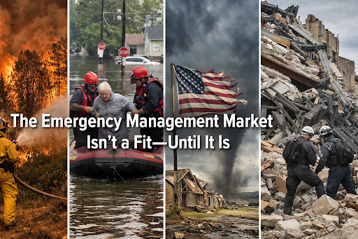
The Emergency Management Market Isn’t a Fit: Until It Is
Let’s be real for a second: if you’re a tech founder or an investor looking for the next "hockey stick" growth curve, the emergency management (EM) sector usually isn’t at the top of your list. It’s a market often dismissed as too intermittent, too bureaucratic, and frankly, too slow. People look at the sales cycles for local government and see a graveyard of good intentions, a labyrinth of RFP requirements, compliance checklists, and pilot-program purgatory. They see a market that only "buys" when things are on fire, literally, making revenue modeling feel like trying to predict the weather.
The common refrain in Silicon Valley and beyond has been that the emergency management market isn’t a fit. It’s too niche. It’s too unpredictable.
But that mindset is a luxury we can no longer afford. Because in our world, the "unattractive" market becomes the center of the universe the exact moment a crisis strikes. When the hundred-year flood happens for the third time in a single decade, or a wildfire driven by shifting climate patterns wipes out an entire zip code in an afternoon, the calculus changes instantly. Those "niche" tools become the decisive factor between a community recovering in months or suffering economic and social stagnation for years. Technologies that were shrugged off as "nice-to-haves" during dry budget hearings suddenly become mission-critical lifelines during the chaotic first 72 hours of a disaster.
The "Not a Fit" Fallacy
Historically, tech firms have focused heavily on everyday applications, social media algorithms, frictionless food delivery, hyper-targeted ad-tech, because the consumer demand was constant and the barriers to entry were incredibly low. This relentless focus on the everyday left emergency agencies practically abandoned, stuck managing the worst days of our lives with profoundly outdated tools. We see major incident command centers still relying on legacy spreadsheets passed around via email, physical whiteboards, and "boots-on-the-ground" assessment processes that haven't fundamentally evolved since the mid-1990s.
The financial logic was simple, if deeply flawed: Why invest millions in R&D to build for a disaster that might not happen for five years?
The problem with that logic today is that disasters are no longer intermittent anomalies. They are becoming significantly more frequent, vastly more intense, and exponentially more expensive to recover from. The so-called "slow" government resilience market is actually a $137 billion sleeping giant, projected to swell to over $196 billion by 2030, driven by aging infrastructure and climate volatility.
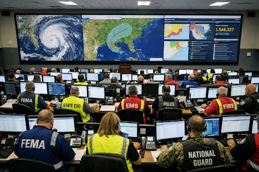
(Description: A high-angle FEMA multimedia photo showing a multi-agency Emergency Operations Center (EOC) filled with monitors and personnel during a major hurricane response, showcasing the high-stakes environment where data becomes mission-critical.)
When a major crisis hits, the venture capital conversation drastically changes from "Is this a scalable fit for our portfolio?" to "How fast can we deploy this to stop the bleeding?" Suddenly, the "slow" government procurement process gives way to emergency declarations, and the market becomes a desperate, fully-funded race for immediate solutions.
When the Unprecedented Becomes the Standard
Every community will eventually face the unprecedented; it is no longer a matter of if, but when. We saw it in Kentucky in 2021 when a devastating, unseasonal tornado carved a geographic scar across the state, shattering historical expectations of what a storm could do to modern infrastructure. We saw it again with the overwhelming storm surge of Hurricane Ian in 2022.
In these critical moments, geospatial data and modern, ruggedized technology are required to speed up decisions that used to take weeks of grueling administrative labor. In the past, assessing widespread damage required thousands of expensive, dangerous man-hours. It meant sending teams of assessors into hazardous, debris-filled neighborhoods with paper clipboards and pens, dodging downed power lines and navigating washed-out roads. If you’ve ever tried to maintain version control on a federal disaster declaration form while standing in three feet of toxic floodwater, you know that "boots-on-the-ground" is an agonizingly slow way to get financial help to desperate survivors.
During Hurricane Ian, the operational paradigm fundamentally shifted. FEMA leveraged high-resolution aerial imagery and geospatial analytics to execute over 56,000 remote damage assessments within the initial 72 hours. Think about the scale of that achievement: in just three days, they identified approximately 24,000 damaged homes using high-resolution imagery and AI-driven classification from miles away.
This isn't just a "cool tech" story for a press release. This is a story about the velocity of aid. By automating the preliminary assessment, recovery teams were mobilized on the ground in 48 hours, not three weeks. The digital survey didn’t just replace a paper map; it shortened the agonizing timeline between a survivor’s worst day and their first recovery check. It meant the difference between a family being able to rebuild or being forced to abandon their community entirely.
The Market Pivot: From Reactive to Proactive
The emergency management technology sector is growing at a robust CAGR of 6.1% for a very specific reason. There is immense, compounding pressure on state and local governments to execute and fund disaster operations locally, as federal support slowly shifts toward a more decentralized model. The federal cavalry simply cannot be everywhere at once. State and municipal-level technological capacity is no longer an optional luxury; it is a baseline requirement for civic survival.
Tech entrepreneurs often overlook the sheer scale of the ecosystem, forgetting that emergency management is a massive, all-hands-on-deck effort. It isn't just FEMA and the Red Cross. It’s the local utility company trying to optimize route planning to safely restore power. It’s the network of regional NGOs trying to secure temporary housing for 500 displaced families before nightfall. It’s the insurance companies desperately trying to process thousands of claims before the mold sets into the drywall.
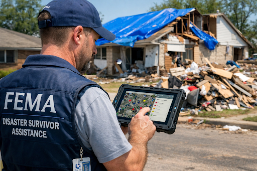
(Description: A FEMA multimedia library photo of a disaster survivor speaking with an inspector holding a tablet, illustrating the transition from paper-based legacy systems to digital, geospatial-enabled recovery tools.)
What the entire industry desperately needs is technology that bridges the massive gap between simply "having a pretty map" and having the rigorous, concrete evidence required to trigger federal declarations, unlock funding, and route physical aid to the right street corner at the right time.
Bridging the Gap: Why Readiness Matters
The hard truth of this industry is that technology developed in a Silicon Valley vacuum, without talking to the exhausted people who actually use it in the mud, the rain, and the chaos, will inevitably fail. This is exactly why so many "smart" tech solutions stumble during their first real-world deployment. They are built for the climate-controlled office with gigabit fiber, not the austere environment of the field.
To truly be a "fit" for the emergency management market, a product must adhere to three non-negotiable pillars:
Mission-Ready: It has to work flawlessly when the local cell towers are completely down, the power grid is fried, and you’re running off a spotty, low-bandwidth satellite uplink. Offline functionality isn't a feature; it's a prerequisite.
FEMA-Aligned: Emergency management runs on standardized doctrine. If your software doesn’t output data formatted to match the exact requirements of a federal disaster declaration or incident command system, it’s just a distraction. You haven't solved the problem; you've just created a new data silo for an overworked official to manage.
Low Friction: In a crisis, cognitive load is maxed out. A responder on hour 18 of a grueling shift, wearing thick tactical gloves in the pouring rain, does not have the patience for a five-step multi-factor login or a cluttered, complex user interface. Simplicity equals speed.
We are already seeing a massive doctrinal shift to support this technological adoption. The updated FEMA Preliminary Damage Assessment (PDA) Guide formally recognizes "virtual sensing" and "digital surveys" as legitimate evaluation tools. The government is literally rewriting the rulebook to ask for more tech. They are kicking the door open.
For innovators and investors, the lesson is clear: Don’t wait for the calamity on the news to realize the value of the market. By the time the storm hits the coast, it’s far too late to start your R&D or test your beta. You need to be actively engaging with EM professionals right now. You need to intimately understand the on-the-ground pain points of the search and rescue teams, the logistics coordinators, and the recovery directors.
The Shift to Actionable Data
This glaring, industry-wide gap between available tech and operational reality is exactly why we started Balor Analytics. We saw brilliant, multi-million-dollar geospatial tools sitting completely unused on the shelf because emergency managers were too overwhelmed struggling with 20-year-old administrative processes to learn them.
We realized that in a crisis, raw data is often a liability, not an asset. More data points just lead to alert fatigue. The data must be instantly actionable. We don't need another generic heat map; we need a flashing red arrow pointing to the most vulnerable populations. Whether it's rapid post-catastrophe imagery or predictive analytics for complex flood modeling, the ultimate goal must always be the exact same: radically accelerating the speed to decision.
The emergency management market is undoubtedly tough. It’s demanding. It’s high-stakes, and the bureaucracy can be incredibly frustrating. But it’s also one of the very few places in the tech ecosystem where your code, your hardware, and your algorithms can actually save a life, rescue a livelihood, and rebuild a city.
Join the Mission
This article is the first in our ongoing "Bridging the Gap" series in partnership with Project Geospatial. Over the coming weeks, we’re going to dive deep into why product-market fit is so notoriously hard in crisis response, why human trust is the primary currency of emergency management, and how we can effectively build a more resilient "whole-community" approach to facing inevitable disasters.
The market may seem like a tough, unyielding fit during the calm, blue-sky times. But when the sky turns gray, the wind howls, and the sirens start blaring, proven, rugged, and doctrinally aligned tools won’t just be a "good fit", they will be the only lifeline a community has left.
At Balor Analytics, we're deeply committed to helping organizations navigate the complex, high-stakes world of emergency management technology and turn raw data into rapid, equitable recovery. Let’s build something that works when it matters most.