
Wireless Sensor Networks: The Missing Link in Modern Intelligence

Simulated battlespace: Motes are deployed within a denied battlespace, forming a mesh network. A semi-buried satellite uplink enables the streaming of measurement and signature intelligence (MASINT) data for GEOINT processing, analysis, and dissemination.
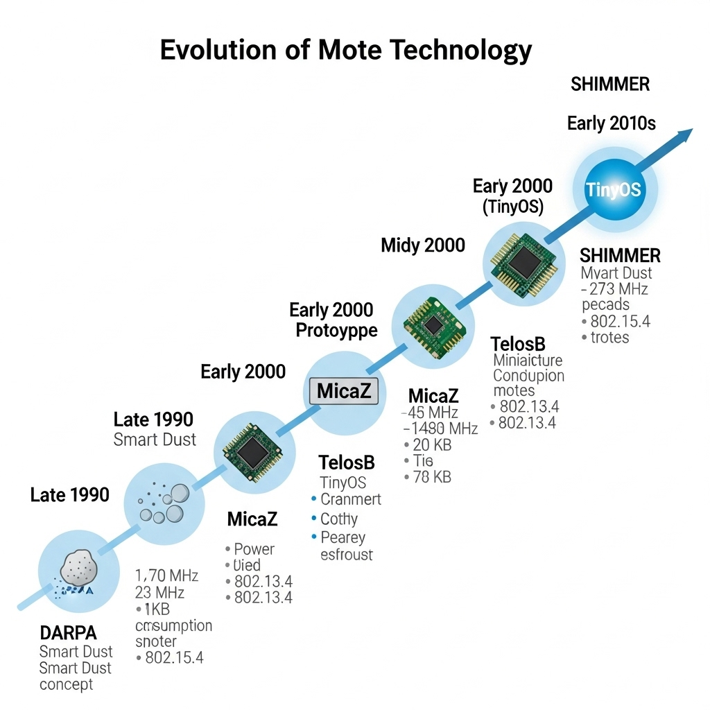
From DARPA to SHIMMER, the development of motes and smart dust.
The intelligence community (IC) currently faces a challenge that OSINT cannot fill in. The technology capable of revolutionizing battlespace Intelligence, Surveillance, and Reconnaissance (ISR) operations has been available and operational in commercial applications, such as viticulture, for over two decades, yet it remains largely untouched. This failure to integrate mature Wireless Sensor Network (WSN) technology, sometimes referred to as “motes” or “smart dust,” constitutes a critical, multi-decade strategic lapse that the U.S. Government and defense contractors must address.
The root of this overlooked capability dates to 1997, when DARPA funded the revolutionary “Smart Dust” concept. According to Wikipedia’s documentation (https://en.wikipedia.org/wiki/Smartdust), by 1998, Dr. Kristofer Pister’s work at UC Berkeley had led to working prototypes successfully demonstrating the feasibility of creating nearly invisible intelligence networks across vast territories.
Mote technology matured during the early 2000s, transitioning from theoretical concept to practical implementations. Platforms such as MicaZ, TelosB, and SHIMMER emerged during this time. Today, in 2025, while commercial smartphones are supercomputers and satellite imagery resolution has reached sub-centimeter scales, this established foundational sensor technology has yet to be widely deployed operationally for defense Geospatial Intelligence (GEOINT) and ISR.
We must recognize the critical flaw in current intelligence practices, that the dependence on static, time-lagged data needs to be addressed. Intelligence workflows routinely task analysts with interpreting and distributing information that’s already hours or even a day old. Data intended to inform decisions about rapidly shifting threats must be current, timely, and accessible. Currently, imagery delays stem from satellite revisit intervals or scheduled aircraft and UAS overflights, resulting in operational latency. That latency translates into real-world vulnerability, increasing the exposure of warfighters to hazards such as improvised explosive devices. The reliance on nonpersistent and open-source intelligence (OSINT) and the lack of credible human intelligence (HUMINT) are drivers of this intelligence gap. This causal chain means mission objectives are frequently supported by suboptimal, outdated information, preventing the realization of continuous battlespace awareness that technology promises.
Addressing this strategic gap requires an authoritative perspective grounded in deep technical and acquisition experience. The analysis presented herein leverages extensive expertise in defense and national intelligence, and extensive research forming the background and understanding that the technology gap from the early 2000s is rapidly closing.
Recently, SAIC stated, “Innovation starts with bold ideas and the courage to build them.” That audacious idea is now.
Vulnerability Amplification of the Static-Data Trap
The limited adoption of mature WSN technology is not due to the sensors themselves, but to the significant gap between sensor network capabilities and the integration capacity of existing COTS GEOINT platforms. This gap has created a reliance on a static-data trap that fundamentally compromises the operational relevance of remotely sensed data.
GEOINT professionals are familiar with the leading GEOINT platforms, specifically BAE SYSTEMS’ Geo eXploitation ecosystem, NV5’s ENVI, Hexagon Geospatial’s ERDAS IMAGINE, and Esri’s ArcGIS. These software solutions were initially designed for static datasets, such as structured databases, vector, and raster data. These COTS platforms excel at processing a snapshot of reality. However, until recently, they struggled with real-time streaming data. The critical implication is that intelligence analysts are provided with inherently historical data, assessing today’s threats based on geospatial data collected yesterday. This latency contrasts sharply with the sensor-enhanced possibility, where the same analyst could, in theory, access real-time environmental conditions, movement patterns, and threat indicators continuously updated across thousands of sensor points.
We must rigorously quantify the cost of this lack of integration, not as budget shortfalls, but as strategic risk. Today, remotely sensed intelligence collection, requiring satellite or air asset tasking, involves substantial planning, personnel, processing, and high costs. Relying solely on conventional, temporal methods leaves predictable intelligence gaps. U.S. adversaries are actively developing autonomous, distributed technologies, including artificial intelligence/machine learning (AI/ML) counterintelligence systems, to exploit time gaps. The primary “Need” is therefore not about achieving lower operational costs but about securing continuous situational assurance (SA) and maintaining decisive battlespace dominance by closing the data-time gap and reducing the need for OSINT to fill in the gaps.
Platform Status Versus Institutional Lag
An assessment of current COTS platform capabilities and readiness confirms that the technology gap and limitations are institutional rather than technological. Commercial organizations, such as BAE SYSTEMS, Palantir, and Esri, have already demonstrated the technical feasibility of integrating WSNs. For example, Esri’s ArcGIS Enterprise has documented capabilities for real-time sensor integration via its GeoEvent Server and Velocity platforms. Additionally, the BAE SYSTEMS Geospatial eXploitation ecosystem, including GXP Fusion, can integrate information from multiple data sources. Those platforms consume event-based data streams and perform analytics using Internet of Things (IoT) sensors, such as wireless sensor networks (WSNs). This commercial validation reduces the perceived technical risk for defense implementation.
EMS Geospatial eXploitation ecosystem, with its multi-source data fusion capabilities and open architecture, provides a foundation for sensor integration. While Hexagon’s ERDAS IMAGINE has powerful analytical workflows using the Spatial Modeler, it is optimized for traditional imagery processing rather than high-volume, continuous sensor streams. The evidence suggests that while the capabilities exist at the fringes of these platforms, the government sector has failed to allocate the dedicated resources required to develop standardized, secure, and compliant integration protocols necessary to transition sensor potential into operational reality. This failure constitutes a lapse in proactive industrial strategy. The U.S. government should develop the standards, codebases for classified sensors, and doctrine necessary for commercial entities to integrate, then deploy systems capable of providing real-time intelligence for decision-makers and warfighters.
The Implementation Framework: A Phased Approach to GEOINT Fusion
The solution to the integration challenge is not a single product acquisition, but a systematic, executable, phased framework that treats the WSN integration as a strategic capability development program. This approach directly addresses the current gap by providing a structured path forward, resolving the “Need” identified in the previous section. The implementation framework required to move beyond theoretical capability to operational reality involves four critical phases:
Phase 1: Pilot Deployments and Feasibility Validation: This initial step involves testing sensor data ingestion and integration with existing GEOINT workflows. This phase is crucial for validating technical feasibility and ensuring operational utility in a controlled environment.
Phase 2: Development of Standardized Protocols and Security Frameworks: Once feasibility is proven, the focus shifts to creating standardized data models/schemas for WSN payloads and the necessary ingestion protocols, critical for a scalable GEOINT architecture. Additionally, this phase must include the development of robust security frameworks tailored to stringent ISR requirements.
Phase 3: Training and Doctrine Development: The new sensor-enhanced ISR operations require adapting analytical workflows, developing new training curricula, and formalizing doctrine.
Phase 4: Scaled Deployment with Comprehensive AI/ML Integration: Only upon successful validation of the first three phases can a scaled, comprehensive deployment proceed, contingent on robust integration with AI/ML workflows.
Technical Feasibility and the AI/ML Imperative
The framework’s viability is grounded in proven commercial validation. Organizations such as BAE Systems, Esri, and Palantir have already demonstrated the technical feasibility of ingesting and processing continuous sensor streams. This commercial success provides tangible proof of concept, effectively de-risking the technical challenge for defense implementation and shifting the focus to addressing security, reliability, and specific operational requirements that exceed commercial standards, thereby reducing the government-off-the-shelf (GOTS) dilemma.
Crucially, the solution must eclipse mere data collection. The integration must treat WSNs not just as a data source, but as the foundation for distributed autonomous analytical systems. The data generated by WSNs, including ephemeral data that is difficult to collect without persistent surveillance, is massive and continuous. Translating this volume of data into actionable intelligence requires integrating these WSNs with agentic AI/ML workflows. This integration transforms the sensors from passive data collectors into distributed analytical engines capable of collaborative analysis and emergent pattern recognition at the edge. This capability is mandatory for reducing the cognitive load on human analysts and accelerating the decision loop, aligning directly with modern defense modernization goals focused on multimodal AI and autonomous Command and Control (C2).
Painting the Future: Strategic Imperatives
Senior decision-makers, whether government or corporate, must act on the technical benefits and the strategic advantages WSNs provide in denied territory. The design, integration, and deployment of motes/WSNs and the supporting GEOINT architecture provide three primary strategic imperatives:
1. Continuous Situational Assurance (SA)
Traditional intelligence-gathering methods rely on expensive and vulnerable assets (aircraft, UAVs, satellite revisit cycles), which create intermittent coverage gaps and expose them to risk. The widespread deployment of WSNs eliminates the need for a constant logistical footprint, providing continuous, 24/7 SA across vast territories. This fundamental shift changes the operational risk profile, enabling forces to move and operate with greater confidence, informed by uninterrupted battlespace knowledge.
2. Predictive Pattern-of-Life Analytics
The technical capability for environmental intelligence enhancement, which enables modern sensor networks to monitor diverse data, including temperature, acoustic signatures, vibration patterns, and electromagnetic emissions, directly translates into predictive pattern-of-life analytics. When this measurement and signature intelligence (MASINT), electronic intelligence (ELINT), and GEOINT data are fused, ML models can detect anomalies and infer intent, enabling pattern recognition that is simply impossible using OSINT, visual, or human-derived intelligence alone. This capability transforms passive surveillance into proactive, predictive intelligence gathering, allowing command elements to anticipate adversary maneuvers and preemptively mitigate threats.
3. Distributed Autonomous Analytical Systems
Network-based intelligence, integrated with agentic AI/ML, enables the creation of distributed, autonomous analytical systems. These networked sensors act as intelligent, self-optimizing ecosystems. By performing collaborative, real-time analysis at the edge, where the data is collected, the network drastically reduces the time required to translate raw data into actionable intelligence. For operational commanders, this means instantaneous, filtered intelligence relevant to their immediate area of operations, resulting in a massive acceleration of the decision loop and a decisive advantage over adversaries reliant on legacy, centralized processing architectures.
The Outcomes of WSN Integration: The Strategic Decision Point
The IC stands at a clear strategic inflection point where mature sensor technologies, evolving geospatial platforms, and advancing AI/ML capabilities have converged to offer unprecedented opportunities for enhanced ISR and GEOINT operations. The critical constraint is no longer technological maturity but institutional velocity and the absence of a systematic, high-security integration strategy. The question is not whether this integration will happen automatically, but whether leadership—both government and contractor—will invest in the systematic development, testing, and validation required to seize the strategic advantage now to maintain velocity.
The path forward requires moving beyond conceptual potential to empirical validation through structured, defensible programs that address the unique security and operational requirements of defense intelligence. The analysis shows that the integration gap is narrow and defined, requiring focused effort on protocol standardization and security framing, following a successful, low-risk pilot program.
Initiating the Structured Pilot Partnership
Business-to-Government (B2G) and Business-to-Business (B2B) thought leadership aimed at gaining operational advantage: this is your call to action—real-time intelligence fusion to address the latency risks identified in traditional ISR methodologies is necessary to transition the theoretical potential of WSNs into operational reality. Defense contractors today are uniquely positioned to organize the specialized expertise required to bridge defense acquisition compliance (FAR/DFAR, ITAR), military GEOINT doctrine, COTS platform mastery (SOCET GXP, ArcGIS, ERDAS), and complex proposal development. Intelligence professionals and program managers must schedule a mission requirements workshop and validate the technical feasibility of integrating real-time WSN data with existing COTS platforms to secure persistent intelligence dominance.