
Deploying Wireless Sensor Networks: Enabling Scalable Intelligence in Contested Environments
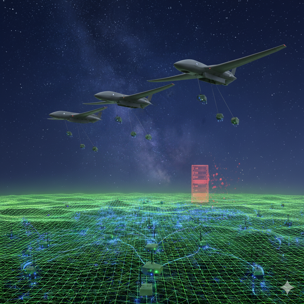
Unmanned aerial systems (UASs) deploy unattended ground sensors (UGSs) to form a wireless sensor network (WSN) for persistent terrestrial monitoring, where OSINT falls short.
Today's defense operations require continuous, 24/7 Situational Awareness (SA) across vast denied areas. Current intelligence, surveillance, and reconnaissance (ISR) paradigms rely on high-value, intermittent platforms, such as air and space reconnaissance assets, vulnerable to kinetic strikes and electronic warfare.
Deploying thousands of Wireless Sensor Networks (WSNs) at scale presents a logistical, technological, and operational challenge that requires new doctrine, specialized hardware configurations, and integration with existing geospatial intelligence (GEOINT) ecosystems, such as BAE SYSTEMS' GXP ecosystem, Esri's ArcGIS Pro platform, and Palantir.
How can the U.S. Department of Defense (DoD) achieve scalable, cost-effective WSN deployment that provides persistent intelligence while minimizing risk to personnel and enabling integration with established systems, such as the Distributed Common Ground System - Army (DCGS-A)?
Is a viable solution possible?
A comprehensive deployment framework combining air-dropped swarm doctrine with ruggedized commercial off-the-shelf (COTS) WSN technology, leveraging attainable asset economics and partnership with leading GEOINT ecosystem providers, and U.S. government organizations such as the U.S. Army Topographic Engineering Center (TEC) and program executive offices (PEO) such as PEO Special Operations Forces Digital Applications (PEO SDA).
The solution is to deploy thousands of inexpensive, durable sensors and mini-ground stations from air assets, such as unmanned aerial systems (UASs). These sensors work together as a network and are low-cost. Losing many of them doesn't affect mission effectiveness. The sensor data streams from device to device, then to a mini-ground station, where it is uploaded to an air or space asset, allowing edge computing to be executed. Next, the data streams directly or indirectly into existing military intelligence systems, such as DCGS-A, to synthesize and fuse multi-INT data, and then disseminate relevant threat information.
The Current Intelligence Gap
Persistent surveillance in denied areas is a challenge present-day military operations face. The use of open-source intelligence (OSINT) to fill the gaps that traditional human intelligence (HUMINT) once filled is a significant business opportunity. Janes and other open-source experts claim to provide a critical understanding of denied areas. Intelligence Analysts leverage Janes and other OSINT sources as the sand to fill in the gaps in coverage, fusing fragmented data with authoritative intelligence to make critical decisions.
The flaw with OSINT is that it is inherently difficult to verify the temporal accuracy and reliability of the data. WSNs solve this by acting as a critical 'verification layer.' While OSINT provides the broad context, WSNs provide the ground truth required to confirm these indicators. Real-time streams of remotely sensed data via WSNs can fill the intelligence persistence gap that traditional air- and space-based ISR assets cannot effectively address. Additionally, high-value platforms, including manned reconnaissance aircraft, UASs, and tethered aerostats, provide superior intelligence quality but operate under significant constraints:
Temporal Limitations: Mission duration is not cost-effective for persistent monitoring
Vulnerability to Countermeasures: Air platforms are subject to adversary air defense systems
Cost to Risk: Single-platform loss represents a substantial financial, operational, and possibly human impact
Coverage Density: Many air- and space-based platforms provide the wide-area spatial resolution required for planning and many operations and missions; however, a WSN can fill the gaps better than OSINT to help maintain mission velocity.
Based on current DoD ISR deployment patterns and the Defense Systems Information Analysis Center's (DSIAC) comprehensive survey of unattended ground sensors (UGS), existing sensor architectures predominantly rely on hand-placed systems with limited coverage radius and operational durations typically ranging from 30 to 200 days (DSIAC, 2018).
Integration Requirements with Existing C4ISR Architecture
The deployment of large-scale WSN systems must integrate seamlessly with established command, control, communications, computers, and intelligence (C4ISR) frameworks, particularly:
DCGS Integration: Compatibility with the Distributed Common Ground System, for all the services and SOF for multi-INT fusion and dissemination
GEOINT Platforms: Direct data feeds to established platforms for spatial analysis and artificial intelligence, and machine learning (AI/ML) augmentation
Mission Command Systems: Real-time sensor status and intelligence product delivery to tactical and operational command levels
Deployment Challenges at Scale
Currently, technological barriers for the mass implementation of WSNs are the principal limitations when scaling beyond experimental deployments. According to the DSIAC technical survey, most UGSs require hand placement. This limits deployment velocity and exposes personnel to hostile environments.
Key technical challenges include:
Power Management: Extended operational periods require sophisticated power management, with leading systems, such as the Textron MO-2730 Node (seismic sensor), achieving over 730 days of operation through solar integration. In contrast, compact systems like the Exensor UMRA Micro (seismic sensor) provide only 5-day operational windows.
Communication Architecture: Self-forming mesh networks must maintain connectivity across varied terrain while providing beyond-line-of-sight (BLOS) capability. Current systems demonstrate ranges from 200m (Lockheed Martin SPAN) to 15km (L-3 Communications REM-Sense ISR), requiring careful network topology planning.
Environmental Resilience: Operational temperature ranges from -40°C to +50°C, and resistance to shock, vibration, and electromagnetic interference represents baseline requirements that eliminate many unhardened COTS components.
Component Technology Assessment Update
Recent assessment of core WSN components reveals mixed availability and performance characteristics:
MSP430 Microcontroller Units: Texas Instruments' MSP430 family remains current and viable, with 2024-2025 variants including the MSP430FR2353 and MSP430FR247x series. These devices maintain ultra-low-power consumption (below 1 μA in standby mode) with 1ms wake-up times, supporting the original technical specifications outlined in the WSN deployment framework.
Analog Devices MEMS Sensors: The current Micro-Electro-Mechanical Systems (MEMS) portfolio includes tactical-grade sensors that exceed original specifications. The ADXL380/382 triaxial accelerometers (sampling phase, 2024) provide 16-bit resolution with 85dB dynamic range, while the ADIS16488 IMU achieves tactical-grade (<10°/hr) bias stability. Cost projections for integrated MEMS+MCU assemblies remain within the $100-$500 per unit range when procured in large quantities.
Operational Doctrine Gaps
Deployment Methodology
Traditional UGS deployment doctrine emphasizes covert hand placement by SOF, limiting deployment velocity and scale. The transition to air-dropped swarm deployment requires fundamental doctrinal evolution:
Air-Dropped Sensor Systems: While McQ Inc.'s (https://www.mcqinc.com) Air Deployed Sensor Systems demonstrate air-drop capability for weather monitoring, military-grade WSN air deployment remains mainly between the theoretical and developmental stages. The DoD's Replicator program, which aims to target thousands of autonomous aerial systems, provides a potential delivery mechanism but requires the development of WSN-specific integration.
Swarm Coordination: Recent developments in UAS swarm technology demonstrate promising capabilities. The Perdix System (https://www.war.gov/News/Releases/Release/Article/1044811/department-of-defense-announces-successful-micro-drone-demonstration), which has been operational since 2016, has undergone extensive testing, including integration with the F/A-18. However, sensor deployment integration with autonomous swarm platforms requires additional development.
Integration Architecture Challenges
GEOINT Platform Connectivity
Successful WSN deployment requires seamless integration with established GEOINT ecosystems:
BAE SYSTEMS: The GXP ecosystem's modular architecture supports sensor data ingestion, but requires standardized protocols for WSN data formatting and metadata management. Partnership development must address data fusion algorithms and visualization capabilities specific to distributed sensor networks.
Esri: ArcGIS Pro Compatibility requires the ability to ingest real-time sensor data streams into ArcGIS Pro's or Velocity’s spatial analysis framework, as well as the development of specific connectors and data models for WSN-generated intelligence products.
DCGS Framework Integration: The Distributed Common Ground System requires WSN data to conform to established intelligence formatting standards while maintaining real-time processing capability for thousands of simultaneous sensor feeds.
Achieving Scalable WSN Deployment
Given these technological and operational challenges, the DoD and industry partners must implement a comprehensive WSN deployment capability that:
1. Achieves Scale: Deploy thousands of sensors, streaming real-time data, across denied and BLOS territory with minimal personnel exposure
2. Maintains Persistence: Provide continuous intelligence collection over extended operational periods to fill in the gaps that OSINT tries to fill
3. Ensures Integration: Seamlessly connect with existing C4ISR and GEOINT platforms
4. Optimizes Cost-Effectiveness: Leverage attritable asset economics while maintaining operational effectiveness
5. Enables Rapid Deployment: Transition from concept to operational capability within current acquisition timelines
Time for Action
The comprehensive WSN deployment framework addresses the DoD’s persistent intelligence requirements while leveraging proven COTS technology and established industry partnerships. By combining air-dropped swarm deployment doctrine with ruggedized sensor technology and seamless GEOINT platform integration, this approach provides a scalable, cost-effective, persistent surveillance capability essential for operations in contested environments.
The framework's emphasis on attainable asset economics and partnership with industry leaders, including BAE SYSTEMS, Esri, and Palantir integration, ensures compatibility with existing C4ISR architecture while providing the operational flexibility required for evolving threat environments.
Success metrics include the deployment of over 1,000 sensors per network, providing 90-730+ day persistent coverage at costs significantly lower than traditional ISR platforms, with seamless integration into established intelligence workflows and enhanced force protection through reduced personnel exposure during deployment operations.
With mature COTS components, easily validated deployment methodologies, and established integration pathways, this WSN framework represents a capability that demands immediate development and implementation to maintain the U.S.'s intelligence advantage in an increasingly contested global environment.
-
Defense Systems Information Analysis Center (DSIAC). (2018). "Unattended Ground Sensor Survey." Retrieved from: https://dsiac.dtic.mil/technical-inquiries/notable/unattended-ground-sensor-survey
Department of Defense. (2024, December). "Strategy for Countering Unmanned Systems." Pentagon Official Statement. https://www.war.gov/News/Releases/Release/Article/3986597/dod-announces-strategy-for-countering-unmanned-systems
Defense and Security Monitor. (2025, January). "Drone Wars: Developments in Drone Swarm Technology." https://dsm.forecastinternational.com/2025/01/21/drone-wars-developments-in-drone-swarm-technology
U.S. Army. (2025, January). "Swarm Technology in Sustainment Operations." Army Sustainment Magazine. https://www.army.mil/article/282467/swarm_technology_in_sustainment_operations
Texas Instruments. (2024). "MSP430 Microcontroller Family Technical Documentation." https://www.ti.com/sc/data/msp/databook/chp1.pdf
Analog Devices, Inc. (2024-2025). "MEMS Sensor Product Portfolio and Technical Specifications." https://www.analog.com/en/product-category/sensors.html