
The Concrete Archipelagos: A Geospatial Excavation of Project NIKE and the Architecture of American Nuclear Defense
The Geometry of Fear
Image 1: Data regarding NIKE Hercules, and AJAX Systems around the US during the Cold War
The view from low Earth orbit, or more commonly today, the view from a web-browser-based digital globe, reveals the surface of the United States as a palimpsest of infrastructure. We see the bold strokes of the interstate highway system, the sprawling grey dendrites of urbanization, and the rectangular patchworks of agricultural zones. However, when one overlays specific historical datasets, such as from older KML files painstakingly compiled by hobbyist imagery analysts and Cold War historians, a different, more menacing cartography emerges. These digital pushpins, scattered in tight rings around major metropolitan areas, do not mark shopping malls or distribution centers. They mark the skeletal remains of Project NIKE, the United States’ first and most extensive surface-to-air missile (SAM) defense system.
This report, rooted in the analysis of these crowdsourced geospatial archives and historical records, seeks to excavate the "Ring of Steel" that once encircled the American heartland. Between 1953 and 1979, the U.S. Army Corps of Engineers constructed nearly 300 of these missile batteries, creating an intricate defensive architecture designed to intercept Soviet bombers before they could unleash thermonuclear annihilation upon American cities and industrial centers. The data provided helps us produce an overview visualized in a dark mode map, screenshots showing orange clusters around cities like Chicago, Detroit, and New York, indicates a desperate, resource-intensive strategy of point defense [Image 1, Image 2].
To understand the Nike system is to understand the psychology of the mid-century United States. It was an era where the threat of apocalypse was not abstract but geometric; it had a speed (500 mph), an altitude (60,000 feet), and a trajectory (over the North Pole). The Nike sites were the physical manifestation of the containment policy, concrete sentinels buried in the backyards of Long Island and the hills of Los Angeles, waiting for a "Blue Alert" that would signal the end of the world. By tracing these sites through the lens of the "hobbyist archivist", those dedicated individuals who hunt for the tell-tale geometric signatures of abandoned radar towers and concrete launch pads on satellite imagery, we uncover a story of technological hubris, nuclear brinkmanship, and the silent, concrete ghosts that still watch over the American landscape.
The KML files, often updated by veterans and enthusiasts like Thomas Page and Ed Thelen, serve as a digital preservation tool for a physical history that is rapidly being erased by suburban development. These files allow us to perform a "digital archaeology," peeling back the layers of modern redevelopment to find the standardized footprints of the Cold War. As we zoom in on these coordinates, we find that the "Ring of Steel" was not a monolith, but a complex organism of radar sensors, analog computers, and hypersonic missiles, integrated into the very fabric of civilian life they were meant to protect.

Image 2: NIKE Systems surrounding major cities such as New York, Pittsburg, Chicago, Detroit, Washington DC, Baltimore and others
The Technological Genesis of the Shield
The Bomber Gap and the Bell Labs Solution
The genesis of Project NIKE lies in the closing months of the Second World War. By 1944, the U.S. War Department had recognized a terrifying trend: the speed and altitude of offensive aircraft were outpacing the capabilities of conventional anti-aircraft artillery (AAA). The V-2 rocket and the jet engine signaled the dawn of an era where a bomber could fly at 500 mph at altitudes exceeding 60,000 feet, rendering traditional "flak" guns nearly useless. The margin for error had vanished; the United States needed a weapon that could chase a target, not just fill the sky with shrapnel.
In May 1945, Bell Laboratories submitted a proposal for "Project Nike," named after the Greek goddess of victory. The concept was a line-of-sight, rocket-propelled missile system guided by ground-based radars and computers. The project brought together the titans of the American military-industrial complex: Bell Labs designed the guidance and computer systems, Western Electric served as the prime contractor, and Douglas Aircraft Company manufactured the airframes.
The urgency of the project was catalyzed by the geopolitical shocks of 1949. The Soviet Union detonated its first atomic bomb (RDS-1), ending the American nuclear monopoly years earlier than predicted. Simultaneously, the success of the Berlin Airlift and the formation of NATO solidified the Iron Curtain. The Atlantic and Pacific Oceans, once reliable moats defending the continental United States, were now vulnerable to the long-range aviation of the Soviet Air Forces, specifically the Tupolev Tu-4 (a reverse-engineered B-29) and later the jet-powered Tu-16 and the massive Tu-95 "Bear".

MIM-3 Nike-Ajax
By U.S. Army - Redstone Arsenal Historical Informationhttp://www.redstone.army.mil/history/archives/ajaxphotos/nike_ajax_32.jpg, Public Domain, https://commons.wikimedia.org/w/index.php?curid=96889
The Nike Ajax: The First Generation
The result of this frantic development was the Nike Ajax (MIM-3), the world's first operational guided surface-to-air missile system, which entered service in 1953. The Ajax was a two-stage missile. A solid-fuel booster rocket provided the initial thrust, launching the missile off the rail and accelerating it through the sound barrier. Once the booster burned out and separated, a liquid-fueled sustainer motor took over, powering the missile to the target.
The propulsion system of the Ajax was a marvel of 1950s engineering, but it was also a logistical nightmare. The sustainer engine used a hypergolic fuel mixture: jet fuel (kerosene) and a red fuming nitric acid (IRFNA) oxidizer. This combination ignited on contact, eliminating the need for an ignition system, but the acid was highly corrosive and toxic. Crews had to wear full protective rubber suits when fueling the missiles, and emergency showers were a standard feature on the launching pads.
The guidance system was a "command guidance" loop, a sophisticated choreography of three radars and an analog computer:
Acquisition Radar (ACQ): A low-power search radar that scanned the horizon 360 degrees to detect incoming targets at long range.
Target Tracking Radar (TTR): Once a target was designated, this radar locked onto it, feeding precise elevation, azimuth, and range data to the computer.
Missile Tracking Radar (MTR): This radar locked onto a transponder beacon within the Nike missile itself, tracking its flight path.
The ground-based computer calculated the "intercept point", the predicted location where the missile and the target would collide. It then sent steering commands to the missile via the MTR. Upon reaching the intercept point, the computer sent a "burst" command, detonating the three high-explosive fragmentation warheads wrapping the missile’s body.
The Infrastructure of Defense
The deployment of the Nike Ajax required an infrastructure program of staggering scale. The Army could not simply place these missiles on existing bases; to protect cities like Chicago, New York, and Los Angeles, the bases had to be in the cities. This necessitated the acquisition of thousands of acres of land, often through eminent domain, in suburban neighborhoods, public parks, and farmland.
The result was the "Defense Area" concept. Each major strategic target was assigned a code (e.g., C for Chicago, NY for New York, LA for Los Angeles) and surrounded by a ring of missile batteries. The KML data provided visualizes this perfectly: the sites are arranged in concentric circles or arcs, spaced to ensure overlapping fields of fire. If a bomber formation penetrated the outer ring, it would face a second or third barrage as it neared the urban core. This "depth of fire" was critical, as the Ajax had a relatively short range of 25-30 miles.
The Anatomy of a Battery – A Geospatial Guide
To interpret the points on the hobbyist's map, one must understand the unique physical footprint of a Nike installation. Unlike a standard military base, a Nike battery was a bifurcated organism. It consisted of two distinct parcels of land, the Integrated Fire Control (IFC) area and the Launcher Area (LA), separated by a distance of 1,000 to 6,000 yards (roughly 0.5 to 3.5 miles). This separation was a technological necessity: the violent vibration and exhaust of a supersonic missile launch would have blinded the sensitive tracking radars if they were co-located.
The Integrated Fire Control (IFC) Area
The IFC was the "brain" of the battery. In satellite imagery, the IFC area is often difficult to distinguish from a generic industrial site or a school (and indeed, many were converted into schools). However, the "hobbyist eye" looks for specific geometric signatures. The IFC was always situated on the highest available ground within the site's footprint to provide the radars with the clearest possible line of sight to the horizon.
The visual signatures of an IFC area include:
Radar Towers: Concrete or steel lattice towers that raised the Acquisition, Target Tracking, and Missile Tracking radars above the tree line. In many abandoned sites, the radars are gone, but the triangular or square concrete footings of the towers remain.
The Van Pads: The earliest systems used mobile trailers to house the radar controls and computers. These trailers were parked on precise concrete pads, often arranged in a specific geometric pattern to minimize cable lengths.
Administrative Buildings: The IFC also housed the battery control trailer, the mess hall, and the barracks for the radar crews. These were typically single-story cinderblock structures.
Because the radars required a commanding view, IFC sites were often placed on prominent hilltops or ridges. In the decades since decommissioning, these locations have become prime real estate. Many former IFC sites in Los Angeles (like Site LA-96C) are now scenic overlooks in public parks, where hikers unknowingly stand on the concrete pads that once guided nuclear-tipped missiles.

This Nike Ajax site is on full alert
By US Army Redstone Arsenal - https://web.archive.org/web/20040306104049/http://www.redstone.army.mil/history/archives/ajaxphotos/nike_ajax_01.jpg, Public Domain, https://commons.wikimedia.org/w/index.php?curid=25931638
The Launcher Area (LA)
The Launcher Area is the "muscle" of the system and is far easier to identify in Google Earth imagery. This area contained the missiles, the warhead storage, the fueling infrastructure, and the launch personnel. It was typically located at a lower elevation than the IFC to ensure that the missile, when fired, did not pass through the radar beam during its initial boost phase.
The visual signature of a Launcher Area is distinct and unmistakable to the trained analyst:
The Double Fence: A high-security double perimeter fence (often chain-link topped with barbed wire) is a standard feature. Even where the fence itself has been removed, the "scar" of the perimeter road or the vegetation difference often remains visible.
The Concrete Apron: A large, paved area used for maneuvering missiles and equipment.
The Underground Magazines: The most definitive feature of a Nike Launcher Area is the presence of underground missile magazines. To save space and protect the missiles from attack (and the neighbors from the missiles), the Army stored them in concrete bunkers buried underground. A typical Nike Ajax battery had three magazines. From the air, these appear as a row of large, rectangular steel doors set flush into the concrete apron. Each magazine had a central elevator door flanked by two personnel access hatches and ventilation exhausts.
The Berms: Earthen berms were often constructed around the fueling and warheading areas to contain accidental explosions or fuel spills. These create a distinct topographical ripple visible in terrain maps or 3D visualizations.
The Underground World
Beneath the concrete of the Launcher Area lay a subterranean fortress. The magazines were concrete boxes, roughly 60 feet long, where missiles were stored horizontally on racking systems. In the event of an alert, a massive hydraulic elevator would lift the missile to the surface. Once on the apron, crewmen would manually push the missile across steel rails to one of four satellite launchers per magazine. The missile would then be attached to the launcher and erected to a near-vertical angle (85 degrees) for firing.
This underground configuration allowed the Army to deploy heavy firepower in dense urban environments. A Nike site could sit across the street from a suburban housing development, its lethal payload completely hidden from view until the moment of crisis.
Table 1: Visual Identification Guide for Nike Sites on Satellite Imagery
| Feature | Location | Visual Signature | Notes |
|---|---|---|---|
| Radar Towers | IFC Area | Triangular/Square concrete footings; lattice shadows. | Often on high ground; look for 3-5 distinct pads. |
| Magazine Doors | Launcher Area | Large rectangular steel plates flush with concrete. | Typically arranged in a row of 3; central elevator door. |
| Berms | Launcher Area | Earthen mounds in U-shape or linear patterns. | Used for blast protection around fueling/warhead areas. |
| Perimeter | Both | Double fence lines; patrol roads. | "Scar" lines in vegetation often persist for decades. |
| Geometry | Relationship | IFC is 0.5–3.5 miles from LA; Line of Sight (LOS). | IFC usually higher elevation; LA usually lower. |
The Nuclear Escalation – Nike Hercules
By 1958, the strategic landscape had shifted fundamentally. The Soviet bomber threat had evolved; aircraft were faster, flew higher, and intelligence suggested they would attack in mass formations to overwhelm American defenses. The Nike Ajax, with its single-channel guidance system (one radar, one missile, one target), faced a saturation problem. If fifty bombers attacked a city simultaneously, a single Ajax battery could only engage them one by one, likely being overrun before it could thin the herd.
The American solution was the Nike Hercules (MIM-14).
The Beast and the Flash
The Hercules was a significant upgrade over the Ajax. It was a larger, more powerful missile using solid fuel for both stages, eliminating the dangerous liquid fueling process of the Ajax. It had a range of over 90 miles (compared to Ajax's 25-30 miles) and could reach altitudes of 100,000 feet.
However, the most significant change, and the one that fundamentally altered the stakes of local defense, was the warhead. While the Hercules could carry a high-explosive fragmentation warhead, its primary payload was the W31 nuclear warhead. This warhead had a variable yield, selectable between 2, 20, or 40 kilotons. To put this in perspective, the bomb dropped on Hiroshima was approximately 15 kilotons.
The strategic logic was terrifyingly utilitarian: if a guidance system cannot track fifty individual bombers, one does not try to hit them with fifty bullets. Instead, one fires a single nuclear missile into the center of the formation and detonates it. The resulting fireball, radiation, and overpressure would destroy or disable the entire squadron of enemy aircraft. This meant that to save an American city from nuclear destruction, the Army was prepared to detonate nuclear weapons in the atmosphere directly above the United States.
Retrofitting the Ring
The introduction of the Nike Hercules is clearly visible in the geospatial record. Because the Hercules had three times the range of the Ajax, fewer sites were needed to defend the same area. This led to a consolidation of the "Ring of Steel." In the Los Angeles Defense Area, the ring of 16 Ajax sites was reduced to just 9 Hercules batteries.
The KML files often show this transition:
Abandoned Ajax Sites: Sites marked as "Ajax only" often show signs of earlier abandonment (late 1950s/early 1960s). These sites were frequently turned over to local municipalities earlier and may be more degraded or redeveloped.
Converted Hercules Sites: Sites that were upgraded to Hercules show specific modifications. The underground magazines were often enlarged or modified to accommodate the larger missiles. New radars, specifically the High-Power Acquisition Radar (HIPAR) with its massive distinctive dome or mesh antenna, were installed at the IFCs.
This creates a "ghost layer" in the data, a stratum of short-lived Ajax sites underlying the longer-lived Hercules network.
The Human Operating System – Life in the Silo
The data points in the KML file represent concrete and steel, but for over two decades, they were inhabited by thousands of young American men, many of them draftees. Life at a Nike battery was a paradoxical mix of suburban banality and apocalyptic terror.
The "Silo Rats" and the Routine
Soldiers stationed at Nike sites were often garrisoned directly on the Launcher Area. Barracks were built mere yards from the magazines housing nuclear weapons. Veterans describe a routine of crushing boredom punctuated by moments of extreme adrenaline. Days were spent maintaining the hydraulic fluids, scrubbing the concrete aprons, painting rocks, and running endless diagnostic checks on the vacuum tube electronics of the radars.
The sites were often integrated into the communities they defended. Soldiers would date local girls, frequent local diners, and host open houses where Boy Scout troops were given tours of the (non-nuclear) parts of the facility. The Army worked hard to project an image of the "Ring of Steel" as a comforting blanket rather than a nuclear tripwire.
The "Two-Man Rule" and the Blue Alert
However, behind the fence, the reality was stark. The presence of "special weapons" (the military euphemism for nuclear warheads) necessitated strict security protocols. The "Two-Man Rule" was absolute: no individual could ever be alone with the missiles, the firing keys, or the warhead arming plugs. Access to the "Exclusion Area", the high-security zone immediately surrounding the launchers, was controlled by a badge exchange system, passwords, and the menacing presence of sentry dogs handled by the Military Police.
The tension peaked during a "Blue Alert" (or "Blazing Skies" drill). Sirens would scream across the facility. Crews would rush from their bunks or mess halls to "Battle Stations." In the underground pits, soldiers would prepare the missiles for firing. This involved connecting the squib cables, checking the hydraulics, and, in the case of a real alert, removing the safety plugs from the W31 warheads.
Veterans recall the cognitive dissonance of these moments. They were training to launch a nuclear weapon that would detonate over their own country, potentially blinding civilians, shattering windows, and raining fallout on the very towns where their families lived. The "fail-safe" mechanisms were physical keys and plugs, but the ultimate fail-safe was the discipline of the crew.
Accidents and Near Misses
While the KML file records the static locations of the sites, it cannot capture the moments when the system nearly failed. The history of Project NIKE is punctuated by "Broken Arrow" incidents and near-disasters that were kept secret for decades.
The Naha Incident (1959): In Okinawa, at a US-controlled Nike site, a Hercules missile was accidentally fired during a circuit test. The soldier conducting the test failed to disconnect the squib cable before applying voltage. The booster ignited, sending the missile smashing through a fence and skipping across the ocean surface. The missile was equipped with a nuclear warhead. Though the safety mechanisms prevented a nuclear detonation, the propellant blast killed two technicians and injured another.
The Korean Launch: In South Korea, a similar incident occurred when a crewman failed to safe a missile during a drill. The missile launched and disintegrated over the countryside. While the warhead was conventional, the incident highlighted the hair-trigger nature of a system designed to react in seconds.
Case Study – The Industrial Heart (Detroit & Pittsburgh)
The research notes a "strong push to defend specific cities." The KML data confirms this, showing dense clusters of sites around the American "Rust Belt." This was not accidental; in the calculus of the 1950s, a long war with the Soviet Union would be won by industrial capacity. Defending the factories was as important as defending the capital.
Detroit: The Arsenal of Democracy
Detroit, Michigan, was perhaps the single most critical industrial target in the United States. During World War II, the Ford River Rouge Complex in Dearborn was the largest integrated factory in the world, capable of turning raw iron ore into finished vehicles (and tanks/planes) in a single location. The Soviets knew this; destroying Detroit would cripple American conventional war-making capability.
The Detroit-Cleveland Defense Area was heavily fortified. The KML file reveals a dense ring of sites:
Site D-06 (Utica/Shelby Township): Located north of the city, this site exemplifies the "suburban defense" model. It was an active Hercules site tasked with protecting the northern approaches to the auto plants. Today, the site has been partially preserved as part of River Bends Park. The concrete pads of the launch area and the outlines of the berms are clearly visible in satellite imagery, a geometric scar in the green space.
Site D-69 (Rouge Park): This site was located directly within the city limits, dangerously close to the population it defended. It was a "dual site" capable of firing both Ajax and Hercules missiles. Its proximity to the River Rouge complex (just a few miles away) underscores the desperation to protect the factory at all costs.
Site D-26 (Belle Isle): A missile battery located on an island park in the Detroit River, illustrating the Army’s willingness to commandeer public recreational space for defense.

Nike site near Pittsburgh
Pittsburgh: The Ring of Steel around the Steel City
If Detroit was the engine, Pittsburgh was the forge. The Jones and Laughlin Steel Corporation and U.S. Steel were Tier 1 targets. The Pittsburgh Defense Area (PI-xx) presented a unique challenge: the rugged, hilly terrain of western Pennsylvania.
Unlike the flat Midwest, where sites could be laid out in standard patterns, Pittsburgh's geography forced the Army to place IFC radars on high peaks while tucking Launchers into deep valleys.
Site PI-93 (Westville/Coraopolis): Defended the western approaches and the heavy industry along the Ohio River.
Site PI-71 (Irwin): Protected the eastern flank.
Site PI-43 (Elrama): Today, this site remains as a rusting skeleton in the woods. The magazine doors are welded shut, but the site is largely intact, a "ruin porn" destination for explorers who trace the outlines of the launch pads through the overgrowth.
The density of these rings, 15 sites around Detroit, 12 around Pittsburgh, speaks to the "attrition" strategy. The Army did not expect to stop every bomber, but they hoped to exact a heavy enough toll to allow some of the industrial base to survive.
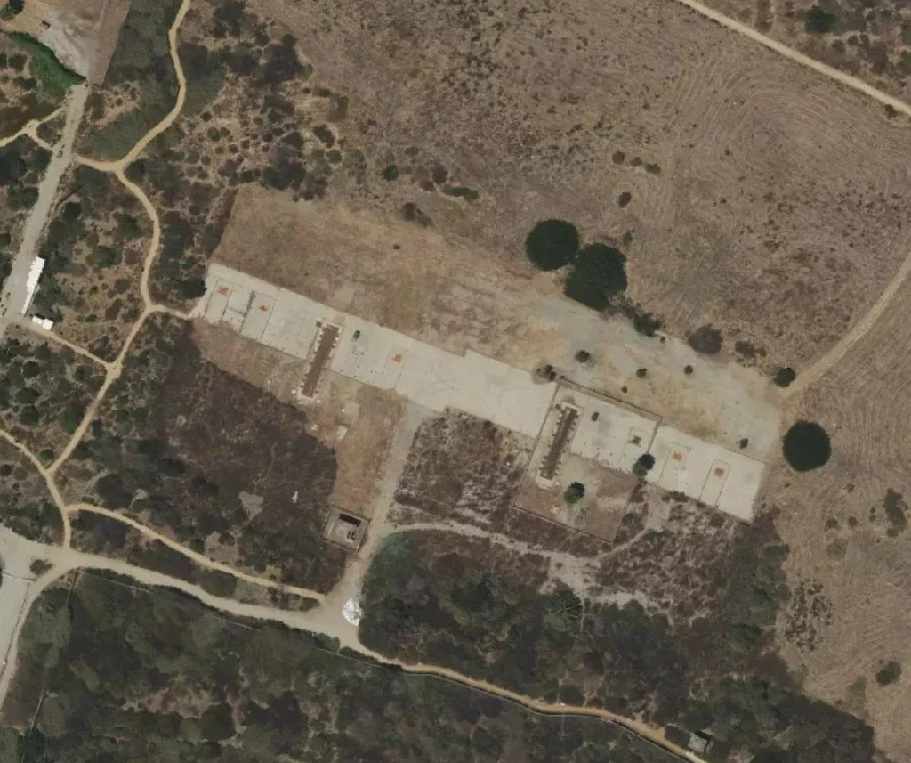
Site LA-43
Case Study – The Coastal Shields (Los Angeles, San Francisco, New York)
The coastal cities faced a dual threat: bombers approaching over the polar route (from the north) or from the Pacific/Atlantic oceans (submarine-launched threats or flanking maneuvers).
Los Angeles: The Ring of Supersonic Steel
Los Angeles was defended by one of the largest networks in the country, the "Ring of Supersonic Steel". The city was not just a population center; it was the hub of the aerospace industry. Douglas Aircraft, Lockheed, and North American Aviation were building the very weapons fighting the Cold War.
Site LA-88 (Oat Mountain): This site is legendary among urban explorers. Perched high on Oat Mountain, it offered a commanding view of the San Fernando Valley and the Pacific. The rugged terrain made construction a nightmare; the Army had to level a mountain peak to build the IFC. Today, the ruins of LA-88 are a haunting destination for hikers. The silo doors remain, surrounded by the graffiti-covered skeletons of the radar towers and administrative buildings.
Site LA-43 (White Point): Located on the coast in San Pedro, this site is now a nature preserve. The launch batteries have been preserved, allowing visitors to walk the concrete apron where nuclear missiles once stood on alert against a Pacific attack. It is one of the few places where the public can physically touch the "Ring of Steel".
Site LA-96C (San Vicente Mountain Park): The IFC site here has been turned into a park where the old radar towers serve as viewing platforms for hikers to see the sprawling city below, a city that was once the target of the radars.
San Francisco: The Rosetta Stone
San Francisco's defense relied on sites like SF-51 (Sweeney Ridge) and SF-88 (Marin Headlands).
Site SF-88: This is the most important site for any researcher or historian. Located in the Golden Gate National Recreation Area, it is the only fully restored Nike site in the country. It operates as a museum where the hydraulic elevators still function, lifting a decommissioned Hercules missile from the dark magazine into the sunlight.5 It serves as the "Rosetta Stone" for interpreting all other abandoned sites visible in the KML files. Seeing the layout of SF-88 allows an analyst to make sense of the crumbled foundations at a place like PI-43 or D-06.
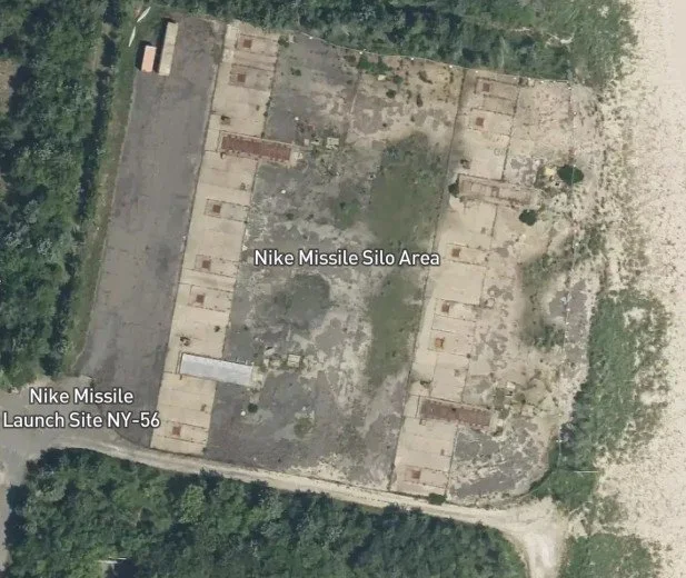
Site NY-56
New York: The Dense Shield
The New York Defense Area (NY-xx) was the densest in the nation, with 19 sites ringing the metropolitan area.
Site NY-56 (Sandy Hook): Located on a barrier spit in New Jersey, this site protected the southern approach to New York Harbor. It is now part of the Gateway National Recreation Area and offers tours.
Site NY-49 (Fort Tilden): Located on the Rockaway Peninsula, this site is now a park, its bunkers reclaiming by the dunes.
Case Study – The Frontier (Alaska & Florida)
While most Nike sites in the continental US were deactivated in 1974, sites in Alaska and Florida remained active for years longer. Their distinct geopolitical contexts kept them on the front lines.
Alaska: Top Cover for America
Alaska was the front line. It was the closest US territory to the Soviet Union and the likely path for any polar bomber attack.
Site Summit (Anchorage): Perched in the Chugach Mountains, Site Summit is one of the best-preserved sites in existence. Unlike the suburban sites of the lower 48, Site Summit was a mountain fortress. Its batteries were active until 1979, guarding the strategic Anchorage bowl and the military bases there.
Live Fire: Alaska was one of the few places where Nike batteries practiced live missile firings (into the ocean), giving the crews there a level of proficiency, and reality, that their counterparts in Chicago or Detroit rarely experienced.
Florida: The Cuban Shadow
Following the Cuban Missile Crisis in 1962, the air defense of southern Florida became a priority.
Site HM-69 (Everglades): Located inside Everglades National Park, this site (originally a temporary mobile setup, later permanent) was maintained to defend against threats from Castro's Cuba. It remained active until 1979, long after the rest of the CONUS sites had closed. Today, it is a historic site managed by the National Park Service, offering a rare glimpse into a "swamp" deployment of the system.
The Civilian Interface
Perhaps the most surreal aspect of the Nike program was its intimacy with civilian life. These were not remote ICBM silos in the Dakota plains; they were neighbors.
The Schoolyard Missile
In many locations, the missile batteries were built adjacent to schools.
Nike Elementary: In Gardner, Kansas, an elementary school was literally built on the grounds of a former Nike site (KC-80). The school is named "Nike Elementary," a bizarre homage to the weapon system that once stood there.
Long Island: In the New York Defense Area, sites were often right next to high schools. Students grew up watching Army trucks move missiles and hearing the sirens of drills. They practiced "Duck and Cover" while real nuclear weapons sat a few hundred yards from their playground.
Public Lands and PR
To acquire the land for these sites, the Army often commandeered public parks (like Jackson Park in Chicago or Belle Isle in Detroit). This led to friction with local communities. To ease fears, ARADCOM launched aggressive PR campaigns. They held "Open House" days, inviting civilians to tour the radar vans and see the missiles (from a distance). They emphasized the name "Nike", Victory, to soften the image of the weapon. The "Ring of Steel" was sold not as a threat, but as a "security blanket" for the atomic age.
Obsolescence and the Digital Afterlife
The Shift to ICBMs
By the mid-1960s, the Soviet threat had shifted from bombers to Intercontinental Ballistic Missiles (ICBMs). A Nike Hercules, designed to shoot down a plane, was useless against a warhead re-entering the atmosphere from space at Mach 20. The Army attempted to develop the Nike Zeus (an anti-ballistic missile), but technological limitations and the signing of the Anti-Ballistic Missile (ABM) Treaty in 1972 effectively killed the program.
The logic of Mutually Assured Destruction (MAD) took over: defense was seen as destabilizing. Only the threat of total retaliation could keep the peace. In this new strategic reality, the Nike sites were expensive anachronisms.
Deactivation and Decay
In 1974, the Army issued the order to deactivate almost all Nike sites in the continental United States.9 The missiles were removed, the fluids drained, the radars dismantled, and the soldiers sent home. The "Ring of Steel" was broken.
What happened to the land? The KML file reveals a spectrum of fates:
Total Erasure: In high-value urban areas, sites were bulldozed for housing or shopping malls. Often, the only trace is a street name: "Nike Drive," "Radar Hill Road," or "Missile Way".
Adaptive Reuse: Many sites were handed over to local municipalities. Launch areas became maintenance yards (the pits were great for working on trucks). Administrative buildings became community centers, rehab facilities, or in the case of Grist House Craft Brewery in Pennsylvania, a place to drink beer in a former missile command center.
Ruins: In remote areas, the sites were simply abandoned. They became "ghost sites," their concrete crumbling, their magazines flooded, visited only by urban explorers and graffiti artists.
The Digital Archaeology
This brings us back to the crowd-sourced analyst's provided data, the KML file. For the modern researcher, these files are not just maps; they are a form of digital archaeology. They allow us to "fly" the globe in Google Earth and spot the signatures of the Cold War before they are completely erased.
The "hobbyist archivist" plays a crucial role here. Individuals like Ed Thelen and Thomas Page have spent decades cross-referencing Army records with satellite imagery to build these databases. They look for the "scars" on the land: the triangular radar pads, the rectangular magazine doors, the berms.
When we look at the KML visualization, the orange dots clustering around our cities, we are seeing the footprint of a massive, collective effort to survive. The data points represent billions of dollars, thousands of careers, and a singular, terrifying purpose.
The Invisible Monument
The Project NIKE system was the most expensive and extensive defensive network ever built on American soil. For twenty years, it placed the capacity for nuclear violence in the suburbs of the nation's greatest cities. It was a mobilization of industry, science, and manpower that rivals the Manhattan Project or the Interstate Highway System, yet it has largely faded from the collective consciousness.
The sites recorded in the hobbyist's KML file are monuments to a war that never happened. They are the archaeological remains of a timeline where the world did not end. Walking through the ruins of site LA-88 or viewing the rusted elevator at SF-88, one feels the weight of the "what if."
The journalist and the historian must look at these KML points not just as coordinates, but as scars. They mark the places where America stood tensed, finger on the trigger, waiting for a sound in the sky that, thankfully, never came. The geospatial data reveals that the "Ring of Steel" was real, but its legacy is one of silence, a silence that we enjoy today, perhaps, because of the deterrent these concrete sentinels once provided.
Yet, this analysis inevitably invites a modern curiosity: if we were to draw a "Ring of Steel" today, where would the pushpins land? The definition of critical infrastructure has mutated since the Cold War. One must wonder if the priority has shifted from the blast furnaces of Pittsburgh to the hyperscale data centers of Northern Virginia, the silent, humming engines of the digital economy. Are the satellite production facilities now churning out constellations for low Earth orbit the modern equivalent of the Willow Run bomber plant? And looking at our massive automotive complexes, we are left with the lingering question of industrial flexibility: could these facilities still beat plowshares into swords, translating assembly lines of electric vehicles into tanks as they did in the 1940s? The Nike sites stand as concrete answers to the fears of 1955; the answers to the fears of 2025 remain, for now, unmapped.
| Feature | Nike Ajax (MIM-3) | Nike Hercules (MIM-14) | Nike Zeus (LIM-49) |
|---|---|---|---|
| Operational Period | 1953–1964 | 1958–1974 (US), 1980s (Europe) | Never Deployed (Test Only) |
| Primary Target | High-Altitude Bombers | Mass Formations, High-Speed Bombers | ICBM Warheads |
| Range | 25–30 Miles | ~90 Miles | >200 Miles |
| Max Altitude | 70,000 ft | 150,000 ft | Space Intercept Capable |
| Warhead | 3 High-Explosive Frag. | W31 Nuclear (2–40 kt) or HE | W50 Thermonuclear |
| Guidance | Command (3 Radars) | Command (Improved Radars) | Command (Target Track/Discrimination) |
| Key Limitation | Single Target Channel | Single Target Channel | Decoy Discrimination |
| Legacy | First Operational SAM | First Nuclear SAM | Precursor to ABM/Patriot |
| Defense Area | City/Target | Key Sites (ID) | Status / Current Use |
|---|---|---|---|
| Chicago-Gary | Chicago, IL | C-41 (Jackson Park) | Demolished / Public Park [1] |
| Detroit | Detroit, MI | D-06 (Utica) | River Bends Park / Partial Ruins [2] |
| Detroit | Detroit, MI | D-69 (Rouge Park) | Demolished / Park [3] |
| Los Angeles | Los Angeles, CA | LA-88 (Oat Mtn) | Ruins / Hiking Destination [4] |
| Los Angeles | Los Angeles, CA | LA-43 (San Pedro) | White Point Nature Preserve [5] |
| San Francisco | San Francisco, CA | SF-88 (Marin) | Restored Museum (NPS) [6] |
| Pittsburgh | Pittsburgh, PA | PI-43 (Elrama) | Abandoned / Private Property [7] |
| New York | New York, NY | NY-56 (Sandy Hook) | Gateway Nat. Rec. Area / Tours [8] |
| Washington | Washington, DC | W-93 (Lorton) | Prison / Park / Arts Center [9] |
-
Overlays and KMLs – Google Earth Studio, accessed November 22, 2025, https://earth.google.com/studio/docs/advanced-features/overlays-and-kmls/
Nike Site Locations & Status, accessed November 22, 2025, https://ed-thelen.org/loc.html
accessed November 22, 2025, https://en.wikipedia.org/wiki/Project_Nike#:~:text=Project%20Nike%20(Greek%3A%20%CE%9D%CE%AF%CE%BA%CE%B7%2C,the%20Nike%20Ajax%2C%20in%201953.
The Nike Missile System: A Concise Historical Overview, accessed November 22, 2025, https://www.ed-thelen.org/Bender1.html
Nike Missile Site - Golden Gate National Recreation Area (U.S. National Park Service), accessed November 22, 2025, https://www.nps.gov/goga/nike-missile-site.htm
Project Nike - Wikipedia, accessed November 22, 2025, https://en.wikipedia.org/wiki/Project_Nike
Former US soldier details account of 1959 Naha accidental nuke firing fatal to fellow soldiers, accessed November 22, 2025, https://english.ryukyushimpo.jp/2017/11/01/27960/
Creating Google Earth KMZ Files of Georeferenced Historic NIKE Missile Launch Site Aerial Photographs - Geological Society of America, accessed November 22, 2025, https://gsa.confex.com/gsa/2014AM/webprogram/Handout/Paper249111/2014%20GSA%20Poster_NIKE_FINAL-OPT_trans.pdf
HISTORIC CONTEXT OF THE NIKE MISSILE SITE - Fairfax County, accessed November 22, 2025, https://www.fairfaxcounty.gov/planning-development/sites/planning-development/files/assets/documents/laurelhill/history/nikemissilesite.pdf
The Missile Next Door: A Spatial History of Nike Ajax and Hercules - WhiteFleet.net, accessed November 22, 2025, https://whitefleet.net/2020/07/23/the-missile-next-door-a-spatial-history-of-nike-ajax-and-hercules/
Pittsburgh Defense - Nike Historical Society, accessed November 22, 2025, https://nikemissile.org/sites/Pittsburgh/northHillsAaaDefense.shtml
Wall in the Sky: The Untold Story of the Nike Nuclear Missile Shield, accessed November 22, 2025, https://www.ghostsofthebattlefield.org/articles/wall-of-in-the-sky-the-untold-story-of-the-nike-nuclear-missile-shield
Arlington Heights, Col P Schulstad USARC - Illinois Historic Preservation Division, accessed November 22, 2025, https://dnrhistoric.illinois.gov/content/dam/soi/en/web/dnrhistoric/preserve/recordation/il-habs-ck-2012-2.pdf
List of Nike missile sites - Wikipedia, accessed November 22, 2025, https://en.wikipedia.org/wiki/List_of_Nike_missile_sites
Nike Missile Site C-41 - Promontory Point - Jackson Park, Chicago IL - Michael Epperson - Personal Web Pages - Sacramento State, accessed November 22, 2025, https://webpages.csus.edu/epperson/nike/
Nike Missile Site SF-31C - San Leandro, California - Alameda County, accessed November 22, 2025, http://www.acgov.org/board/bos_calendar/documents/CDAMeetings_11_04_21/4Nike%20Hist%20Resources%20Eval%20scan.pdf
NIKE MISSILE BASES | Encyclopedia of Cleveland History, accessed November 22, 2025, https://case.edu/ech/articles/n/nike-missile-bases
Exploring the Nike Missile Site at San Vicente Mountain Park - California Through My Lens, accessed November 22, 2025, https://californiathroughmylens.com/san-vicente-mountain-park-nike-missle-site/
Nike Hercules Missile - Joint Base Elmendorf-Richardson, accessed November 22, 2025, https://www.jber.jb.mil/Services-Resources/Environmental/Nike/Missile/
Visualizing the Distribution and Condition of Cold War Nike Missile Sites in the United States Using ArcGIS and Google Earth, accessed November 22, 2025, https://gsa.confex.com/gsa/2013AM/webprogram/Handout/Paper229310/2013%20GSA%20Poster_NIKE_Sites_opt.pdf
Shelby Township's historic Utica D-06 Nike Missile Site, accessed November 22, 2025, https://www.shelbytwp.org/our-township/resident-information/shelby-township-history/nike-missile-base
NIKE History - Long Beach Public Schools, accessed November 22, 2025, http://www.lbeach.org/schools/nike_history
Nike Hercules - Wikipedia, accessed November 22, 2025, https://en.wikipedia.org/wiki/Nike_Hercules
Nike Missiles - Gateway National Recreation Area (U.S. National Park Service), accessed November 22, 2025, https://www.nps.gov/gate/learn/historyculture/nike-missile.htm
Nike family of missiles: Zeus, Hercules and Ajax | Maxwell Hunter, accessed November 22, 2025, http://www.maxwellhunter.com/projects/nike-missile-family
G. Brown LA88 article - Nike Historical Society, accessed November 22, 2025, https://nikemissile.org/LA88/Chs/la88Chs.shtml
How I Learned to Stop Worrying and Love LA's Cold War-Era Nike Missile Sites - Los Angeles Public Library, accessed November 22, 2025, https://www.lapl.org/collections-resources/blogs/lapl/how-i-learned-stop-worrying-and-love-la-cold-war-era-nike-missile
Nike People, accessed November 22, 2025, https://ed-thelen.org/ppl-n.html
Two-person rule - Wikipedia, accessed November 22, 2025, https://en.wikipedia.org/wiki/Two-person_rule
Individual Training Guide - Nike Historical Society, accessed November 22, 2025, https://nikemissile.org/training/Training2ndBn51stAty.shtml
What We Have, We Shall Defend - Nike Historical Society, accessed November 22, 2025, https://nikemissile.org/ColdWar/whatwehave/
Roger R. Service Story - Nike Historical Society, accessed November 22, 2025, https://nikemissile.org/stories/RogerR/sKoreaLaunch.shtml
Blazing Skies: Boston's Nike Missiles (episodes 226) - HUB History, accessed November 22, 2025, http://www.hubhistory.com/episodes/blazing-skies-bostons-nike-missiles-episodes-226/
U.S. Veterans Reveal 1962 Nuclear Close Call Dodged in Okinawa - Asia-Pacific Journal, accessed November 22, 2025, https://apjjf.org/steve-rabson/4825/article
The River Rouge Complex, WWI – Military History of the Upper Great Lakes, accessed November 22, 2025, https://ss.sites.mtu.edu/mhugl/2017/10/17/the-river-rouge-complex/
Ford Rouge Complex | Detroit Historical Society, accessed November 22, 2025, https://www.detroithistorical.org/learn/online-research/encyclopedia-of-detroit/ford-rouge-complex
Nike Missile Defense System, Site D-06, accessed November 22, 2025, https://ss.sites.mtu.edu/mhugl/2017/10/22/nike-missile-defense-system-site-d-06/
Rouge Park held a cold war missile site : r/Detroit - Reddit, accessed November 22, 2025, https://www.reddit.com/r/Detroit/comments/1i31bzw/rouge_park_held_a_cold_war_missile_site/
Jones and Laughlin Steel Company - Wikipedia, accessed November 22, 2025, https://en.wikipedia.org/wiki/Jones_and_Laughlin_Steel_Company
Pittsburgh Defense Area, accessed November 22, 2025, http://www.astronautix.com/p/pittsburghdefensearea.html
40 years after closure, volunteers restore historic Cold War site - KTOO, accessed November 22, 2025, https://www.ktoo.org/2019/07/08/40-years-after-closure-volunteers-restore-historic-cold-war-site/
Nike Hercules Operations in Alaska: 1959-1979, accessed November 22, 2025, https://dnr.alaska.gov/parks/oha/publications/nikehercops.pdf
Why Nike Bases Become Playgrounds - YouTube, accessed November 22, 2025, https://www.youtube.com/watch?v=PX6Y2d5LU5E
From Boosters To Beers: Disused Nike Missile Command Site Being Turned Into Brewery, accessed November 22, 2025, https://www.twz.com/25935/from-boosters-to-brew-disused-nike-missile-command-site-being-turned-into-brewery