Beyond the Gilded Exterior: Balancing Marketing and Momentum in the St. Louis Geospatial Ecosystem 2026
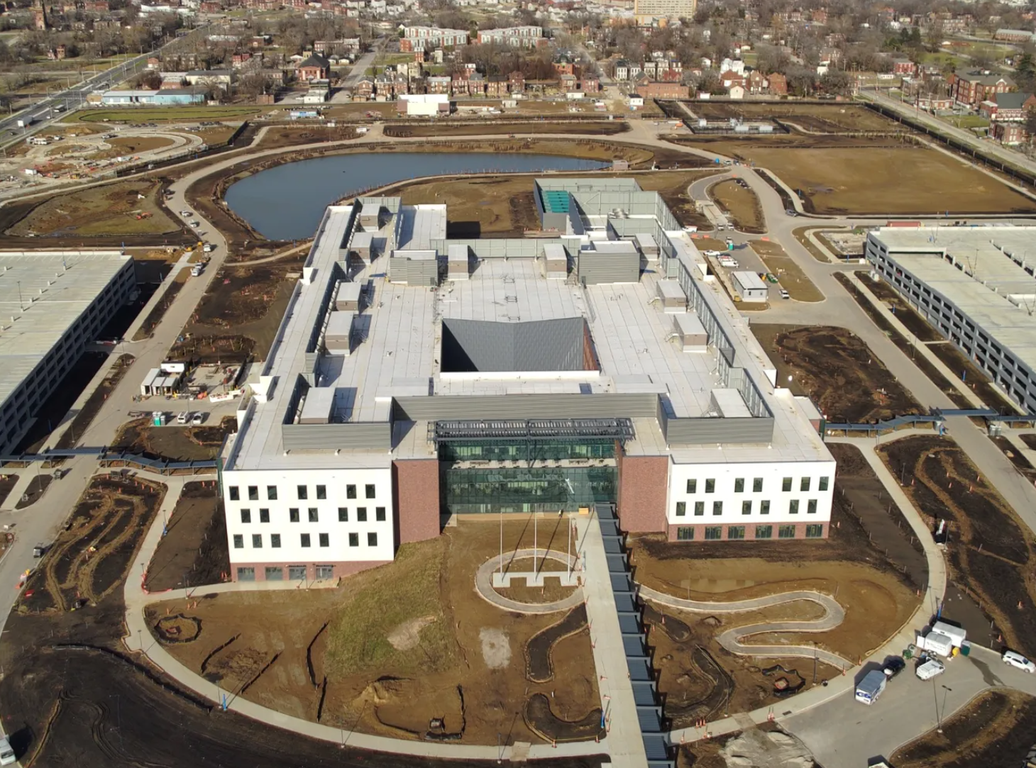
Photo via NGA
The morning sun reflects sharply off the pristine glass and concrete facade of the new $1.7 billion Next NGA West campus in the historic St. Louis Place neighborhood. Standing at the intersection of Jefferson and Cass avenues, this massive, 97-acre federal compound looms over an urban landscape marked by decades of systemic disinvestment. For civic boosters and regional economic development organizations, this architectural giant is a triumph, the physical centerpiece of a sector contributing nearly $5 billion to the local economy and supporting over 10,000 direct jobs. Yet, walk just a few blocks past the armed security gates, and a more complex, emotionally charged reality emerges. To the residents of North St. Louis, the high security walls represent a physical and social barrier. To local technology advocates, the shining facility is a monument to a critical paradox: St. Louis has successfully built the stage, but the commercial actors have yet to arrive.
The central question reverberating through the local technology community is clear: Has the St. Louis geospatial ecosystem genuinely transformed, or has it merely become louder? In the years following the historic federal decision to retain the National Geospatial-Intelligence Agency (NGA) within the city, the region filled the long development gap by heavily doubling down on its marketing. High-profile symposia, philanthropic windfalls, and constant re-branding have spent years painting a polished picture of a booming midwestern tech capital. However, now that the facility is a physical reality, the region must confront what lies beneath that refined exterior: a lingering story of institutional fragmentation, leadership churn, and an uphill battle to turn high-level strategy into actual, on-the-ground employment.
An investigation into this transition reveals a region standing at a critical crossroads. With the official launch of the regional backbone organization GeoSTL in early 2026 and the dramatic structural reorganization of the Taylor Geospatial brand, St. Louis is attempting to re-engineer its collaborative model. The coming years, leading up to the return of the prestigious GEOINT Symposium in 2029, will determine whether this midwestern hub can move beyond the creation of high-profile monuments to cultivate a self-sustaining innovation garden.
The Monument of North St. Louis: Next NGA West and the Spatial Divide
For more than seventy-five years, St. Louis has been quietly anchored to the defense intelligence community through the presence of the NGA and its military predecessor organizations. However, this relationship was historically confined to secure, obsolete brick facilities in the Soulard neighborhood south of downtown. The decision to build a state-of-the-art western headquarters in the heart of North St. Louis was hailed as a monumental victory, keeping thousands of high-paying jobs within the city limits and preventing a catastrophic relocation outside the region.
Despite the grandeur of this megaproject, economic realists emphasize that the $1.7 billion investment represents a physical relocation and modernization of an existing workforce. This development represents a spatial transition of existing federal personnel, leaving net federal funding levels and regional employment figures unchanged. The immediate economic benefits are primarily defensive, protecting an existing municipal tax base.
Furthermore, the physical design of the campus has drawn sharp criticism from urban planners. Built as a highly secure, fortress-like enclave, the facility is surrounded by robust security perimeters that cut it off from the adjacent North St. Louis neighborhoods. The campus functions as an isolated enclave, which limits its integration with adjacent neighborhoods and highlights a persistent gap between national security infrastructure and local community development.
Re-Engineering the Collaborative Architecture: The Launch of GeoSTL
Recognizing that a physical building cannot single-handedly spark an industrial revolution, regional leadership has spent years trying to organize a cohesive economic strategy. For several years, this effort was spearheaded by GeoFutures, an initiative convened by the regional economic development group Greater St. Louis, Inc. (GSL). GeoFutures established a ten-year strategic roadmap focused on scaling talent, raising innovation capacity, and accelerating entrepreneurship. However, the initiative often struggled with execution, leaving a leadership vacuum after the departure of key industry experts.
To bridge this operational gap, regional leaders officially launched GeoSTL in January 2026, transitioning the entity into its active operational phase on February 26, 2026. Formed as a Missouri-approved nonprofit applying for federal 501(c)(3) status, GeoSTL functions as the regional "backbone organization" for the bi-state area’s geospatial economy. GeoSTL operates as a non-competing regional entity, focusing its mandate on aligning, coordinating, and advancing the regional strategy.
Ecosystem Leadership Transition
The operational evolution of St. Louis' geospatial backbone
GeoFutures
- Established the baseline 10-Year Strategic Roadmap for regional expansion.
- Convened initially as a temporary coalition under Greater St. Louis, Inc.
- Faced operational execution bottlenecks after key departures left direct expertise voids.
GeoSTL
- Structured as an independent, non-competing regional 501(c)(3) backbone entity.
- Led by Executive Director Mark Munsell (Former NGA CTO/CAIO).
- Charged with direct execution of the 2025-2028 Implementation Plan.
- Focuses on hard economic metrics over soft marketing appeals.
At the center of this new operational phase is Mark Munsell, appointed as GeoSTL’s Executive Director. Munsell is a highly respected figure in the national security technology landscape, having previously served as the Chief Technology Officer and the inaugural Chief Artificial Intelligence Officer at the NGA. His transition from the highest levels of the federal intelligence community to local civic leadership brings immense credibility and deep federal connections to the regional effort. Supported by a staff that includes Strategy Director Peter Tchoukaleff, Molly Brady in Policy, and Jennifer Goldring in Communications, Munsell is tasked with executing the GeoFutures Strategic Roadmap and Implementation Plan (2025–2028).
Whether by design or necessity, local leadership is finally recognizing this pivot. This execution strategy took center stage at the recent GeoSTL Q2 2026 Ecosystem Meeting hosted at the Missouri History Museum on July 7, 2026. During the briefing, leadership announced that its four core strategic priority committees, Talent, Innovation, Growth, and Championing St. Louis, have officially transitioned from high-level planning concepts into active, community-facing working groups explicitly tasked with reducing operational friction across the bi-state area.
While the name instinctively anchors the organization to the geospatial sector, its official branding deliberately utilizes 'GEO' as a dual-purpose double entendre. The organization’s mission is explicitly coded into this tagline acronym, slickly transforming a standard industry shorthand for location science into a direct, measurable mandate for 'Growing Economic Opportunity'. By aligning the efforts of public, private, academic, and community stakeholders across a 15-county bi-state region, the organization seeks to translate St. Louis's historic geospatial assets into a competitive global market. One of the entity's first critical tasks is establishing an accurate baseline of regional employment data. While GeoSTL’s legacy is tied to the broad economic marketing of Greater St. Louis Inc., Executive Director Mark Munsell notes that the organization's strategic understanding of the market “will be formed based on the report,” effectively acknowledging that hard firm and job numbers have historically gone untracked or have been inconsistent with industry reality. This rigorous approach signals a deliberate shift away from the region’s historical reliance on soft, cultural appeals, such as civic call-outs to toasted ravioli, when presenting proposals to prospective companies. By leveraging Munsell's deep federal intelligence and technical background, GeoSTL aims to replace superficial marketing with an unassailable, data-driven index of localized technical capabilities, forcing a mature economic conversation focused strictly on hard economics, payroll growth, and actual job placement.
The Jobs Inflection Point: Behind the Curtain of Marketing
While the marketing of the St. Louis geospatial ecosystem has never been louder, the region is facing a sobering inflection point. Over the past decade, philanthropic donors have poured millions of dollars into the sector, government officials have launched at least eight separate initiatives and incubators, and local universities have rapidly expanded their geospatial curricula. Yet, an honest assessment of the metropolitan area reveals that the highly anticipated flood of commercial jobs has not yet arrived.This gap highlights a parallel narrative within the technology community, one where a polished, gilded image actively conceals deep-seated internal strife. The prevailing regional strategy has historically focused on shining a powerful spotlight through aggressive branding and major funding announcements, while consistently struggling with the less glamorous work of building genuine connective tissue. Consequently, instead of operating as a unified innovation hub, the ecosystem frequently functions as a fragmented collection of disconnected theme parks, with individual institutions operating under their own banners and competing for external attention rather than contributing to a shared economic identity.
"All of that stuff is great but it means nothing if we don't have jobs to put them in," Munsell remarked candidly in April 2026, pointing to the stark reality that marketing victories must eventually be backed by economic payrolls. While the broader bi-state strategic roadmap estimates that geospatial technology supports roughly 27,000 jobs across diverse applications, the core technology cluster remains heavily reliant on federal employment and a small group of defense contractors.
This pattern of top-heavy promotional strategy is on full display in the region's fall 2026 event scheduling. By pairing the CaGIS 2026 Conference (September 8–11), which centers on 'The Cartographer in the Loop: Balancing Technological Innovation with Human Expertise,' with the one-day Geo-Resolution Conference 2026 on September 10 under the theme 'Securing the Future with Geospatial,' civic boosters are executing a familiar outward-facing play. The core objective behind these back-to-back gatherings is to synthetically manufacture market collisions by exposing external, legacy St. Louis businesses, firms historically detached from advanced location science—to the tech cluster. Rather than waiting for enterprise demand to evolve organically, the ecosystem relies on high-visibility event booking to artificially drag traditional regional industries into its orbit.
To illustrate the sheer density of this regional marketing strategy, one need only look at the ecosystem's immediate calendar. During the GeoSTL Q2 2026 Ecosystem Meeting, leadership proudly displayed an aggressive, back-to-back schedule of regional programming:
St. Louis Geospatial Ecosystem: 2026 Event Schedule:
| Date (2026) | Event Name | Focus / Host |
|---|---|---|
| July 10 | NGA AI Industry Day | Defense / Intelligence |
| July 13–17 | ESRI User Conference | Global GIS |
| July 18 | Unleashing Potential Cardboard Boat Regatta | Community Engagement |
| July 23 | BioGenerator Innovators' Hour | Biotech / Startups |
| August 20 | Plant Science Family Reunion | Agriculture / Biotech |
| August 26 | USGIF St. Louis Area Community of Interest Meeting | Defense / Intelligence |
| August 27 | BioSTL Breakthrough 25 Gala | Innovation / Biotech |
| September 8–11 | CaGIS Conference | Academic / Cartography |
| September 10 | Geo-Resolution Conference 2026 | NGA & SLU |
| September 22 | Q3 Geospatial Ecosystem Meeting | GeoSTL (Hosted at SIUE) |
| September 25 | Danforth Center Young Friends Party with the Plants | Agriculture / Community |
| October 22–23 | Lindenwood University GIS Day & GeoAI Symposium | Academic / AI |
| November 18–19 | SatSummit | Common Space, Taylor Geospatial, & DevSeed |
This cyclical reliance on marquee events to mask underlying fragmentation is a repeating playbook that carries deep institutional scar tissue. Insiders and organizers explicitly flagged this dynamic as an existential threat to the region's credibility, documenting a rising fear of a "bait and switch" sentiment, where the region aggressively markets a world-class geospatial ecosystem without actually investing in the hard work of ecosystem building. A telling precedent occurred in 2024, when the prominent open-source community FOSS4G was actively encouraged to host its conference in St. Louis to deliberately coincide with Geo-Resolution. Outwardly marketed as a triumph of ecosystem integration, the reality behind the scenes was one of total institutional abandonment. Despite a dedicated push by then, Executive Director Dr. Nadine Alameh, a globally respected figure who personally championed the open-source movement, the rigid academic machinery around her refused to move. While Dr. Alameh stepped into the breach to deliver a powerful keynote address , the broader Taylor Geospatial Institute (TGI) ecosystem left its own director stranded. Crucially, TGI’s heavily funded partner universities completely failed to participate, leaving the national open-source technology sector feeling fundamentally exploited and betrayed by a regional hierarchy eager to leverage external brands for civic PR but completely unwilling to engage in authentic, peer-level collaboration.
This historical abandonment exposes a deeper, ongoing contradiction regarding localized academic credibility, specifically within the Geo-Resolution framework co-hosted by Saint Louis University (SLU) and the NGA. While the conference stage is immaculately dressed to project a regional center of intellectual gravity, it highlights a persistent effort by SLU to artificially engineer “knowledge expertise” from the top down. The institution frequently maneuvers internal academics into prominent thought-leadership slots despite the fact that many of these faculty members operate within insular campus silos and fail to actively participate in the broader, highly competitive national geospatial research community. The resulting friction point is unmistakable: the front-end marketing portrays a world-class academic engine, while the back-end execution remains detached from macro-level national workflows, leaving the ecosystem dependent on engineered prestige rather than authentic, peer-verified industry influence.
When prestige is engineered rather than earned, the injection of massive federal capital becomes a risky wager. As highlighted in the GeoSTL Q2 Ecosystem Meeting, SLU recently secured a $4.2M grant from the NGA for a new geospatial center. The capital is certainly flowing, but the true test is whether this funding will dismantle SLU's insular silos or simply reinforce them.
The St. Louis Talent Squeeze
A structural mismatch between academic output and regional absorption
Academic Supply
- Rapidly expanding geospatial degree curricula and professional certificates.
- Generating a high volume of annual graduates in geographic location sciences.
- Heavily backed by specialized regional and national academic partnerships.
Commercial Realities
- Slower relative creation of high-paying non-defense, commercial jobs.
- Limited access to early-stage commercial venture and expansion capital.
- Active "brain drain" as top-tier local graduates exit to Denver, Austin, and D.C.
Local industry experts observe that the region’s promotional strategies have historically focused on cultural appeals. Munsell urged regional leaders to abandon cultural references such as toasted raviolis in favor of hard economics when presenting proposals to prospective companies. He highlighted that many talented innovators who were born or educated in St. Louis has historically left the region, taking their ideas to Silicon Valley, Boston, or Washington, D.C..
To counter this systemic brain drain with hard numbers, GeoSTL highlighted an ongoing, NGA-funded geospatial workforce talent assessment during the Q2 meeting. Conducted by Deloitte Consulting with T-REX serving as the prime contractor, this federal evaluation is designed to empirically define and map the metropolitan area's exact job footprint. For GeoSTL and its regional partners, this assessment will establish a sobering baseline to align academic output with concrete corporate demand. To anchor this effort, leadership is launching an interactive 'Digital Opportunity Hub' directly on the GeoSTL portal next month to act as a centralized matchmaking ecosystem for local employers and job seekers.
This sentiment is echoed by other key players in the local market. Brian Monheiser, the Head of Growth at T-Kartor USA, argues that while there have been clear gains in terms of local activity, events, and institutional engagement, these milestones have not yet translated into defined innovation or a significant influx of new companies and personnel. He notes that for St. Louis to achieve its lofty ambitions, it must aggressively expand beyond national defense contracting into high-growth commercial sectors such as transportation logistics, precision agriculture, and environmental monitoring. This structural transition is vital as the region navigates a long, quiet gap until the prestigious GEOINT Symposium returns to the city in 2029.
The corporate and startup landscape reflects a diverse but highly fragmented industry base, as outlined in the following table:
St. Louis Geospatial Ecosystem Directories
A comprehensive tracking directory of the commercial entities, startups, and academic anchors driving the regional market footprint.
| Company Name | Area of Specialization | Market Segment / Scale |
|---|---|---|
| Boeing | Aerospace and defense autonomous systems integration into aviation platforms. | Multinational Corp |
| Bayer Crop Science | Precision agriculture analytics and localized macro satellite data analysis. | Multinational Corp |
| Leidos | Government contracting, systems integration, and intelligence support for the NGA. | Defense Contractor |
| Maxar | High-resolution satellite imagery acquisition, analytics, and earth observation workflows. | Major Geospatial Player |
| GDIT | Secure cloud computing IT networks, intelligence systems delivery, and SCIF operations. | Defense Contractor |
| Esri | Geographic Information Systems (GIS) standard mapping software suites and local deployment. | Global GIS Leader |
| Scale AI | High-fidelity deep learning training data generation specialized for government GEOINT. | Specialized Provider |
| Seiler Geospatial | High-precision physical mapping hardware, surveying equipment distribution, and GNSS systems. | Regional Service Provider |
| Aisle411 | High-precision indoor spatial computing, mapping, and retail navigation systems. | Location-Tech Startup |
| Applied Particle Technology | Real-time smart environmental monitoring integrated with localized spatial sensor networks. | Clean-Tech Startup |
| Blue Line Technology | Intelligent automated transportation tracking frameworks and localized security software. | Tech Startup |
| Coolfire Solutions | Real-time operational communication tools and mobile situational awareness infrastructure. | Emerging Tech Startup |
| Eemerg Roadside Assistance | On-demand location-based roadside assistance delivery interfaces and routing tools. | Consumer Tech Startup |
| Geodata IT | Advanced database architecture, secure geospatial information management, and analytics. | Defense IT Startup |
| Geosaurus St. Louis | Regional workspace coordination, innovation clearinghouse, and spatial resource network. | Ecosystem Org |
| Hire Henry | Robotic commercial automation setups connecting targeted trades with location tracking data. | Hardware Startup |
| Kwema | IoT safety wearables incorporating localized immediate threat response and rapid tracking systems. | Hardware & IoT |
| T-Kartor USA | Advanced cartographic database operations, spatial literacy pipelines, and professional analyst training. | Specialized Provider |
| Thouvenot, Wade & Moerchen Inc. | Civil engineering design, baseline property land surveying, and master municipal GIS layout. | Regional Provider |
| Surdex Corporation | Aerial photogrammetry processing, airborne Lidar acquisition, and advanced digital ortho-mapping. | Specialized Subsidiary |
| Hydrosat | Thermal satellite infrastructure deployment and localized environmental/agricultural stress analytics. | Climate-Tech Startup |
| Turnberry Solutions | IT consulting, secure cloud integration architectures, tech execution, and regional AI strategies. | Private Enterprise |
| Gateway Geospatial Group | Targeted GEOINT execution, open-source intelligence analysis (OSINT), and specialized DoD/IC operations. | Small Business |
| Pinnacle Geospatial | Location asset analytics, baseline infrastructure modeling (BIM), and commercial consulting pathways. | Consulting & Service |
| Omni Federal | Custom geospatial application layer engineering, agile cloud services, and database software for the government. | Software Contractor |
| Organization Name | Primary Mission / 2026 Role | Key Initiatives / Active Programs |
|---|---|---|
|
GeoSTL
Ecosystem Backbone |
Acts as the independent, non-competing regional 501(c)(3) backbone organization coordinating the 15-county bi-state geospatial strategy. | Stewardship of the 2025–2028 Implementation Plan, comprehensive regional employment baseline indexing, and regional corporate talent alignment. |
|
Taylor Geospatial
Research Consortia |
Consolidated standalone scientific research engine focused on GeoAI innovation, commercial startup spinoffs, and shared scientific databases. | "Fields of the World" global agricultural boundaries dataset, open-source AI models, and collaborative research computing infrastructure. |
|
Geospatial Center @ SLU
Academic Center |
Saint Louis University's independent, enterprise-wide geospatial academic pipeline and research platform. | Co-hosting the annual Geo-Resolution Conference with NGA, advanced academic geospatial degrees, and multi-disciplinary university research. |
|
T-REX
Startup Incubator |
Downtown technology accelerator and physical coworking anchor housing localized location-science startups. | Operates the Downtown Geospatial Innovation Center, provides custom dry lab spaces, spatial computing/XR lab facilities, and hardware infrastructure, while hosting NGA's unclassified presence. |
|
NGA Moonshot Labs
Federal Hub |
The National Geospatial-Intelligence Agency's unclassified collaborative innovation hub housed physically inside T-REX. | Facilitates direct, unclassified technology sandboxing between intelligence agency software developers, private industry, and academic groups. |
|
Arch Grants
Early Funding |
Provides equity-free early-stage seed capital to retain and scale high-potential technology startups within the St. Louis metropolitan boundary. | Annual Arch Grants Competition featuring dedicated funding tracks designed to seed, attract, and anchor geospatial technology developers. |
|
UMSL Geospatial Collaborative
Academic Center |
University of Missouri-St. Louis' applied research, workforce training, and regional community development initiative. | Direct academic partnership agreements with the NGA, regional public health cartography mapping, and specialized K-16 GIS pipeline programs. |
|
Washington University in St. Louis
Academic Research |
World-class medical, environmental, and spatial computing research integration via dedicated geospatial research priorities. | Geospatial Research Initiative linking complex global health diagnostics, localized ecological mapping, and high-level location science. |
|
Harris-Stowe State University
HBCU Pipeline |
Historically Black University (HBCU) workforce training, education, and diversity-focused location science pipelines. | Operation of the specialized student GeoHornet Lab, NGA training partnerships, and academic consortia integrations. |
|
Maryville University
Academic Education |
Private higher education provider integrating technology, data science, and modern spatial analytical skills. | Specialized, industry-aligned Geospatial Technology curriculum programs designed to quickly scale local entry-level talent. |
|
Danforth Plant Science Center
AgTech Research |
World-renowned independent plant science institute bridging biotechnology with advanced location science. | Center for AgTech and Applied Location Science and Technology (CATALST) focusing on location-science solutions for global food security. |
|
GIWAC
Workforce Center |
The Geospatial & IT Workforce & Apprenticeship Center focusing on non-traditional talent, career retraining, and technical certifications. | Applied location science training, technical career apprenticeships, and direct pathways linking local communities to NGA-adjacent jobs. |
The Taylor Geospatial Transformation: Overcoming Academic Friction
Nowhere have the internal tensions of the St. Louis ecosystem been more apparent than in its philanthropic and academic research pillars. Established through a historic nine-figure legacy investment from Andrew C. Taylor, the Executive Chairman of Enterprise Mobility, the Taylor Geospatial Institute (TGI) was designed to serve as the world-class research engine of the region. TGI launched as a consortium of eight prestigious midwestern research institutions, led by Saint Louis University (SLU).
However, the institute's early years were marred by intense internal friction. Insiders described the consortium as a battleground for funding rather than a collaborative hub, plagued by academic politics and a lack of mutual trust among historically competitive universities. Critics pointed to a stark credibility gap, noting that the vast majority of the research power was concentrated in just two of the eight partner schools, one of which, the University of Illinois Urbana-Champaign, is located outside of St. Louis.
A major point of contention was the investment in the TGI RAILS supercomputer (Regional AI Learning System), which was funded by the National Science Foundation and TGI, but managed and operated at the National Center for Supercomputing Applications (NCSA) in Illinois. While RAILS features advanced technical specifications, local critics argued that more than half of the consortium's early funding was spent with minimal direct impact on the St. Louis startup ecosystem.
To break this government dependency, the region desperately needs functional, commercial-grade infrastructure, a reality recently acknowledged with the announcement of the Spirit of St. Louis AI Innovation Center. Designed to function as a public “digital utility” akin to a regional power grid or road network, this high-performance compute and storage environment will be open to local researchers, startups, and non-profits, intentionally lowering the technical barriers to entry for early-stage commercial operators.
Beneath the surface of these high-profile funding announcements lay a deeper systemic flaw that critics argue earned the ecosystem its 'gilded' reputation. Historically, the region relied on a top-down, managed oligarchy structure where massive injections of philanthropic cash were expected to instantly manufacture a collaborative culture among historically competitive institutions. Instead of fostering an open innovation ecosystem, this structure created a profound credibility gap, where marketing portrayed a world-class research consortium while the foundational work of cultivating inter-university trust and market alignment remained entirely absent. The academic pillar functioned effectively as an engine without a transmission, mired in institutional politics that left early initiatives with virtually no transferable, market-ready research to offer commercial partners.
Following the departure of inaugural Executive Director Dr. Nadine Alameh, regional leaders recognized that structural changes were necessary. In March 2026, the organization underwent a dramatic re-engineering, merging the Taylor Geospatial Institute and the Taylor Geospatial Engine into a single, unified nonprofit operating simply as Taylor Geospatial.
This restructuring was accompanied by a formal spin-off from SLU. By transitioning Taylor Geospatial into an independent, standalone nonprofit governed by a board chaired by former NGA Director Robert Cardillo, the organization aimed to streamline its decision-making and reduce academic friction. This move allowed SLU to relaunch its own enterprise-wide Geospatial Center on April 15, 2026, while freeing Taylor Geospatial to focus purely on high-velocity commercialization and the development of open-source "digital public goods".
Under the presidency of Elliott Kellner, an EMBA graduate with a background in agricultural science, the newly unified organization has tripled its headcount to accelerate its operations. Rather than funding isolated academic papers, Taylor Geospatial is focusing its resources on building shared scientific infrastructure, such as open datasets, benchmarks, and AI models.
A prime example of this new focus is the launch of "Fields of the World," a global dataset developed in partnership with Radiant Earth that maps agricultural field boundaries across the globe for the first time. Directed by Jennifer Marcus, VP of Strategic Innovation, and Isaac Corley, Director of AI/ML, this initiative demonstrates how the organization is shifting its focus toward scalable, real-world applications of GeoAI.
Crucially, this deliberate pivot toward open-sourcing massive datasets functions as a strategic 'innovation bypass' explicitly designed to navigate the highly risk-averse procurement pipelines of regional heavyweights like Bayer. By standardizing and distributing high-fidelity baseline data, Taylor Geospatial lowers the initial technical and financial barriers that typically cause corporate immune systems to reject early-stage local talent. This provides an accessible baseline where small, agile operators can build enterprise-ready solutions without getting prematurely rejected by rigid institutional risk frameworks.
Breaking the Silos: The Human and Bureaucratic Divide
Despite these structural shifts, St. Louis continues to grapple with deep-seated cultural barriers. The region’s economic development strategy has historically relied on a top-down, managed approach, frequently recruiting high-profile national figures, such as retired NGA Directors Robert Cardillo and Robert Sharp, to lead key initiatives. While these appointments bring valuable federal connections, they have also fueled a perception of insularity.
"There's too much money for the clique to widen the circle or grow the pie," noted a well-placed local source, describing an insular group of insiders who dominate the regional agenda. This closed culture is increasingly viewed as a direct threat to the rapid innovation required to compete with dynamic tech hubs like Denver or Austin. Emily Hemingway, the Executive Director of TechSTL, has publicly challenged this insular dynamic, warning that closed ecosystems are designed to preserve power rather than to innovate quickly. She notes that such systems move slowly, repeat the same conversations, and make safe bets within the same small circles.This insular dynamic highlights a profound structural divergence between St. Louis’s legacy economic model and the fluid growth mechanisms driving dynamic tech hubs like Denver or Austin. While rival ecosystems thrive on decentralized, bottom-up venture networks and a higher velocity of commercial startup capital , St. Louis has historically defaulted to top-down asset aggregation, relying heavily on defensive municipal tax base protection and massive philanthropic infusions to synthetically force economic momentum. The resulting systemic friction leaves the local ecosystem moving at a cautious, bureaucratic crawl, safe-betting within small circles while its primary competitor regions adapt at the rapid pace of the commercial market.
If there is a counterweight to this cautious bureaucratic crawl, it may lie in recent legislative maneuvering. The GeoSTL Champion St. Louis committee touted the passage of the Missouri GIS Advisory Council Act, a milestone proving that while cultural insularity remains an issue on the ground, the structural framework to support location science is successfully penetrating state policy.
This insularity manifests as a systemic "Silo Effect" across the metropolitan area. While physical innovation hubs like T-REX downtown and the Cortex Innovation Community in the Central West End are vibrant assets, they frequently operate as self-contained micro-ecosystems. While T-REX provides foundational incubation and TechSTL offers critical community support, early-stage startups in St. Louis frequently operate in regional isolation, struggling to establish direct, long-term commercial bridges with upstream research hubs like Taylor Geospatial or corporate anchors. This reveals a broader ecosystem-wide disconnect where basic research and agile commercial startup scaling lack a seamless, well-funded pipeline.
While passionate support layers like TechSTL, ArchGrants, and specialized working groups operate tirelessly, their overall economic effectiveness is heavily capped by this broader fragmentation. ArchGrants, for example, successfully injects early-stage, equity-free capital to launch new companies, only to inadvertently deposit them into a localized 'valley of death'. Once launched, these young firms routinely struggle to find a clear pathway into the rigid NGA supply chain or secure meaningful contracts with legacy corporate players. The local support architecture functions well enough at planting seeds, but the regional garden completely lacks the integrated irrigation system required to help those companies scale.
The Silo Effect in Action
Visualizing the systemic fragmentation, velocity mismatches, and severe structural barriers preventing collaboration across key regional assets in St. Louis.
Startups & Labs
- Houses active early-stage technology startups, tech incubators, and unclassified NGA collaborative workspaces.
- Operates on rapid, highly flexible development cycles typically measured in single-digit weeks.
- Operates within a regional ecosystem that currently lacks formal, smooth channels connecting early-stage startups to upstream institutional research.
Innovation Hubs
- Anchors established biotechnology footprints, specialized IT networks, and mature corporate technology tenants.
- Functions primarily as a self-contained micro-ecosystem supported by specialized private capital pools.
- Lacks clear structural runways to integrate directly into downtown startup operations.
Corporate Enterprise
- Dominates regional macro-economic metrics but operates strictly on multi-year development planning horizons.
- Procurement architectures are highly risk-averse, naturally filtering out early-stage commercial talent.
- Rigid institutional risk layers and protective IP frameworks frequently block collaborative local partnerships.
This corporate disconnect is driven by fundamental differences in organizational culture and operational timelines. A multinational corporation like Bayer operates on multi-year development cycles, guided by strict procurement processes and intellectual property protections. Conversely, a young startup operates on a timeline of weeks, relying on open collaboration and rapid market feedback to survive. The corporate immune system naturally rejects these agile, higher-risk partnerships, leaving the region's largest economic pillars effectively isolated from its most innovative entrepreneurial talent.
This corporate disconnect is further exacerbated by a rampant 'buzzword effect' born directly from the region's top-heavy marketing success. Because outward promotional campaigns have been so effective, early-stage startups frequently attach the 'geospatial' label to their pitch decks purely to capture civic attention and funding, even when their core technology is entirely tangential to location science. The unintended consequence is a fundamental mismatch in market expectations. When multinational heavyweights engage these startups, they quickly discover a severe lack of deep technical alignment, triggering a defensive corporate response that naturally rejects local partnerships in favor of safer, established national alternatives.
The challenge is now in the hands of the broader community. Esri’s regional leader, Tara Mott, issued a direct challenge to the ecosystem: "NGA has just opened. It is built, it is here. Has everyone stepped up? How will this community of geospatial rally to support?". This question highlights the transition from physical construction to ecosystem activation.
A Blueprint for Genuine Integration
If St. Louis is to move past its gilded marketing and build a genuinely integrated, self-sustaining economic ecosystem, its leadership must pivot away from top-down management toward a strategy of patient, bottom-up cultivation. This transition requires a series of concrete, systemic reforms designed to dismantle existing barriers and align the region's formidable assets.
Dismantling Insular Gatekeeping
The local technology community must actively break up established power circles by building a more open, merit-based culture. This can be achieved by establishing transparent advisory boards that include prominent national technology figures to challenge local assumptions. Implementing strict term limits for leadership roles within public-private partnerships will ensure a continuous influx of fresh perspectives. Finally, a concerted effort must be made to recruit entrepreneurial leadership from outside the immediate St. Louis market, shifting the organizational culture from exclusive gatekeeping to active mentorship and open opportunity.
An immediate test case for this cultural shift is the newly proposed Geospatial Workforce Hiring Initiative. Moving beyond the standard defense-contracting cluster, GeoSTL is opening an outreach campaign specifically designed to educate and connect business leaders from nontraditional sectors on the enterprise value of spatial thinkers. This initiative strikes directly at the region’s local demand vacuum, actively forcing the ecosystem to widen the circle and integrate with the broader commercial economy.
Enforcing Institutional Accountability
The era of celebrated funding announcements must yield to rigorous, performance-based evaluation. Cornerstone organizations, most notably the newly reorganized Taylor Geospatial, must be held publicly accountable for delivering a tangible return on investment to the local community. The region should establish and track public-facing metrics that extend beyond academic publications to include:
The number of commercial licenses executed.
Local startup spin-outs and corporate partnerships.
Federal research dollars successfully attracted to the region.
High-paying technology jobs directly created by consortium initiatives.
Publishing these metrics on an open, public-facing dashboard will build community trust and force a healthy alignment between scientific research and regional economic growth.
Reconciling the Core Alignment
Bridging theoretical research frameworks with community-level economic value
Scientific & Theory Focus
- Traditional focus centered directly on peer-reviewed academic publications.
- Highly theoretical frameworks functioning over long-term timelines.
- Consortium research models historically insulated from commercial market deployment.
Economic Growth & Velocity
- Performance metrics strictly evaluated on job creation and commercial payrolls.
- Demands repeatable commercial technology spinoffs and local licenses.
- Prioritizes tangible market outcomes for regional taxpayers and funding groups.
Embedding Location Science into Regional Strengths
Instead of promoting a generic, isolated "geospatial-first" identity, St. Louis must focus its positioning on integrating advanced location science directly into its most competitive industrial sectors. This means launching ambitious, cross-disciplinary initiatives that pair geospatial technology with the region’s established economic drivers. For example, a formal collaboration between Taylor Geospatial and the region’s healthcare networks could focus on mapping public health logistics. Similarly, a joint venture with the Danforth Plant Science Center could construct a high-fidelity "digital twin" of regional agricultural systems. By embedding location science into sectors where St. Louis already leads, the region can articulate a unique, market-driven value proposition that resonates on a global scale. Ecosystem leadership is beginning to signal this precise alignment; the GeoSTL roadmaps explicitly called for convening relevant stakeholders across sectors around upcoming high-growth industry summits dedicated to PNT (Positioning, Navigation, and Timing) and Spatial Finance.
De-risking Corporate-Startup Collaboration
Bridge-building between large, risk-averse corporations and agile, early-stage startups requires structured incentives and sandboxed environments. Regional leaders should establish a dedicated co-investment fund where major corporate venture arms and traditional venture capital firms jointly back local geospatial startups. furthermore, the city should pioneer challenge-based innovation programs where federal agencies and large corporations can present specific, real-world operational problems. Startups can then collaborate to solve these issues in secure, unclassified sandboxes with pre-defined intellectual property agreements. This approach shifts the local ecosystem past basic networking meetups, creating the shared risk and reward necessary for true industrial collaboration.
Choosing the Path to 2029 and Beyond
St. Louis stands at a critical juncture, caught between two powerful, competing currents. One current is fueled by a rich geographic history, formidable institutional assets, and transformative philanthropic capital. The other is held back by systemic fragmentation, insular leadership networks, and a historic pattern of independent, siloed operations.
The region has proven that it possesses the civic willpower and financial capacity to build impressive physical monuments. The modern, secure campus of Next NGA West and the newly independent offices of GeoSTL and Taylor Geospatial stand as testaments to this ambition. However, the central challenge of the coming decade lies in building the connective economic channels that will turn these isolated monuments into a cohesive, driving force, an effort that leadership explicitly noted at the latest quarterly meeting must aggressively encompass the broader bi-state region, deliberately leaning into an “Illinois Moment” by deeply integrating cross-river academic and talent hubs like Southern Illinois University Edwardsville (SIUE).
The ongoing, aggressive push by civic leaders to book more high-profile geospatial events is a classic play from the region's established marketing handbook, a tactical effort to maintain an illusion of momentum. But conferences are not an absolute economic benchmark, and the scheduled return of the GEOINT Symposium in 2029 should not be viewed as a finish line. Instead, 2029 represents a looming milestone of evaluation, a hard fiscal audit. This multi-year window provides the region with a finite opportunity to prove that its ecosystem can produce real economic substance. The choices made by leadership today will determine whether St. Louis uses this time to build a genuine, self-sustaining commercial core, or if it is simply playing a massive marketing game that ends in a beautifully designed museum of missed potential.
Hard Questions for the Road to 2029
As the shining new gates of Next NGA West officially open, the window for soft marketing and civic cheerleading has officially closed. If St. Louis is to truly transcend its gilded reputation, the community must confront a series of hard, defining questions:
Is 2026 finally the year St. Louis establishes a hard foundation? With the official operational activation of GeoSTL and the restructuring of Taylor Geospatial, is the region finally building the actual economic plumbing required for commercial tech depth, or are we just shifting the chairs on a highly funded bureaucratic deck?
Will the "Illinois Moment" be genuine, or just a geographical footnote? Leadership has explicitly called for a bi-state approach that leverages cross-river assets like SIUE. Will the traditional Missouri-centric political and academic rivalries yield to a true 15-county regional economy, or will the state line remain an invisible wall for talent and capital?
Is St. Louis finally building a self-sustaining geospatial market, or a perpetual philanthropic dependent? The St. Louis geospatial narrative has been heavily subsidized by massive injections of family foundations and multi-million-dollar civic windfalls. But philanthropy is a catalyst, not a customer. If these capital injections fail to generate predictable, self-sustaining commercial revenue streams and baseline corporate payrolls before the donor enthusiasm shifts elsewhere, what happens to the ecosystem when the safety net is removed? Is the region creating a globally competitive location science market, or simply an artificial, donor-supported habitat that cannot survive the harsh realities of the open commercial software market?
Will the AI Innovation Center democratize data, or entrench the clique? The newly announced high-performance compute environment promises to act as a "digital utility" for the region. Will this compute power actually be accessible to underfunded, scrappy local startups, or will its massive processing capabilities be monopolized by insular academic partners and defensive tier-one military primes?
Are we ready to face the data of the Talent Assessment? For years, the region has blindly boasted about a 'booming talent pipeline' under the marketing umbrella of Greater St. Louis Inc. When the NGA officially releases the findings of its Deloitte-led workforce audit, what happens if the data reveals a vast commercial vacuum and a devastating brain drain to cities like Denver and Austin? Will GeoSTL and its civic backers finally pivot their strategy, or will the region's marketing machinery simply ignore the numbers to protect the narrative?
Can the corporate immune system be broken? We can build data lakes, launch hackathons, and hand out non-equity grants all day. But if the procurement architectures of regional giants like Bayer, Boeing, and Enterprise Holdings remain fundamentally hostile to early-stage, agile local startups, can a self-sustaining commercial ecosystem ever actually take root?
The answers to these questions over the next three years will dictate the ultimate verdict. St. Louis has spent a decade expertly building the stage. Now, the clock is ticking to see if it can actually fill it with players.
-
McCarthy HITT Celebrates Completion and Opening of Next NGA West Campus in St. Louis, accessed July 3, 2026, https://acppubs.com/CD/article/CC9AC027-mccarthy-hitt-celebrates-completion-and-opening-of-next-nga-west-campus-in-st-louis
Next NGA West - City of St. Louis, accessed July 3, 2026, https://www.stlouis-mo.gov/nextngawest/index.cfm
Showcase of a $1.7 Billion Megaproject: National Geospatial Intelligence Campus, accessed July 3, 2026, https://news.constructconnect.com/showcase-of-a-1.7-billion-megaproject-national-geospatial-intelligence-campus
The State of the St. Louis Geospatial Ecosystem 2025: Growth, Challenges, and Future Potential
St. Louis geospatial industry is at an 'inflection point.' Will the jobs ..., accessed July 3, 2026, https://members.techstl.com/st-louis-geospatial-industry-is-at-an-inflection-point-will-the-jobs-come/
Geospatial in St. Louis: A Global GEOINT Hub, accessed July 3, 2026, https://greaterstlinc.com/business/geospatial/
GeoSTL Launches as Regional Backbone for St. Louis' $5B ..., accessed July 3, 2026, https://greaterstlinc.com/newsroom/geostl-launches-as-regional-backbone-for-st-louis-5b-geospatial-economy/
Taylor Geospatial Launches as a New Hub for GeoAI Innovation ..., accessed July 3, 2026, https://taylorgeospatial.org/news/taylor-geospatial-launches-as-a-new-hub-for-geoai-innovation/
St Louis Old Article.txt
Charting the course: Completed mega project maps out lessons in partnership - Army.mil, accessed July 3, 2026, https://www.army.mil/article/290248/charting_the_course_completed_mega_project_maps_out_lessons_in_partnership
McCarthy HITT and NGA Celebrate Completion and Opening of Next NGA West Campus in St. Louis, accessed July 3, 2026, https://www.mccarthy.com/insights/mccarthy-hitt-and-nga-celebrate-completion-and-opening-of-next-nga-west-campus-in-st-louis
Mark Munsell Named Distinguished Fellow of Artificial Intelligence - Lindenwood University, accessed July 3, 2026, https://www.lindenwood.edu/about/news/details/mark-munsell-named-distinguished-fellow-of-artificial-intelligence/
Silicon Valley in St. Louis? - Defense One, accessed July 3, 2026, https://www.defenseone.com/business/2025/10/silicon-valley-st-louis/408542/
WORLD-RENOWNED GEOSPATIAL EXPERT SELECTED AS INAUGURAL EXECUTIVE DIRECTOR OF TAYLOR GEOSPATIAL INSTITUTE - PR Newswire, accessed July 3, 2026, https://www.prnewswire.com/news-releases/world-renowned-geospatial-expert-selected-as-inaugural-executive-director-of-taylor-geospatial-institute-301855788.html
The Taylor Geospatial Institute Regional AI Learning System | New Frontiers Initiative, accessed July 3, 2026, https://newfrontiers.illinois.edu/the-taylor-geospatial-institute-regional-ai-learning-system/
TGI RAILS | NCSA | National Center for Supercomputing Applications | Office of the Vice Chancellor of Research and Innovation | Illinois, accessed July 3, 2026, https://www.ncsa.illinois.edu/research/project-highlights/tgi-rails/
Elliott Kellner - Executive Director at Taylor Geospatial Institute | The Org, accessed July 3, 2026, https://theorg.com/org/taylor-geospatial-institute/org-chart/elliott-kellner
EMBA alum leads geospatial nonprofit focused on AI innovation ..., accessed July 3, 2026, https://olin.washu.edu/about/news-and-media/news/2026/06/emba-alum-geospatial-nonprofit-ai-innovation.php
Geospatial Center @ SLU : SLU - Saint Louis University, accessed July 3, 2026, https://www.slu.edu/geospatial/index.php
Fields of the World on Great Data Products - Taylor Geospatial, accessed July 3, 2026, https://taylorgeospatial.org/news/fields-of-the-world-great-data-products/