
Nation at a Crossroads: FY2026 Budget Proposal Threatens to Dismantle U.S. Geospatial Supremacy, Risking Economic and Infrastructural Integrity
An Unprecedented Assault on Foundational Science and Technology Raises Dire Warnings
WASHINGTON D.C. – A stark vision for America's fiscal future, delivered to Congress under the banner of budget balancing and ideological purity, now casts a long and ominous shadow over the nation's scientific prowess, economic stability, and physical security. The Fiscal Year 2026 Discretionary Budget Request, detailed in a May 2, 2025, letter from the Office of Management and Budget, proposes not just budget cuts, but a veritable demolition of non-defense federal capabilities. With a staggering $163 billion targeted for removal from base non-defense spending – a catastrophic 22.6% reduction – this proposal launches an unprecedented assault on the very agencies underpinning America's world-leading geospatial infrastructure. Cloaked in rhetoric denouncing "wasteful" spending and programs linked to "radical gender and climate ideologies", the plan strikes at the heart of essential government functions: mapping our land, monitoring our environment, forecasting weather, understanding our planet, and providing the precise spatial awareness crucial for modern life. This is far more than a budget proposal; it's a potential self-inflicted wound that threatens to unravel decades of scientific achievement, leaving the nation dangerously vulnerable and economically disadvantaged. The shockwaves ripple far beyond agency budgets, signaling a potential crisis in geodesy, profound risks to critical infrastructure, destabilized supply chains, and a cascade of negative economic consequences that could hamstring the U.S. for generations.

The Assault on the Data Lifeblood: Foundational Streams Under Threat
The very bedrock of the geospatial industry – reliable, accessible, scientifically validated data about our planet – is directly targeted by the proposed cuts, threatening to choke off the essential information that fuels geospatial products, services, and innovation:
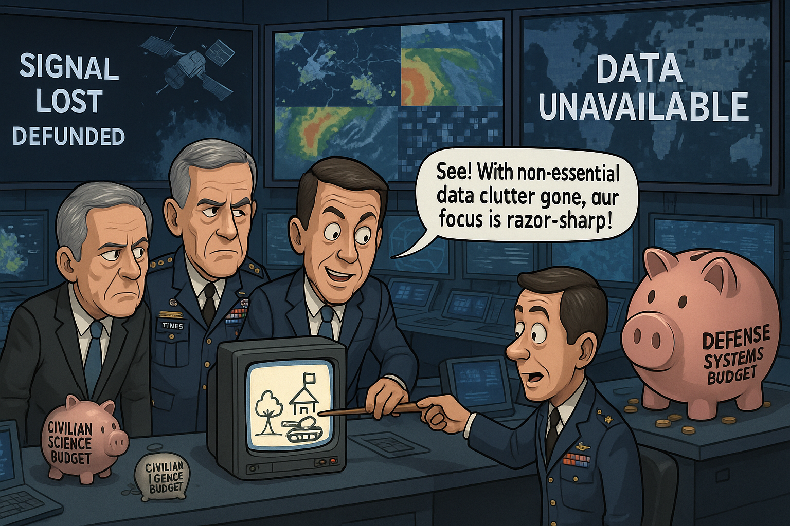
NOAA Cuts Imperil Weather, Climate & Ocean Intelligence: Proposed cuts exceeding $1.3 billion to NOAA's operations, research, and grants, explicitly targeting climate-dominated research and educational grants deemed "environmental alarmism" , combined with a $209 million reduction in satellite procurement impacting future weather satellites like GEO XO , represent a devastating blow. Geospatial companies providing weather analytics, climate risk assessment, agricultural technology, coastal management solutions, maritime logistics support, and insurance modeling rely heavily on NOAA data streams. Shutting off or degrading these public data sources cripples the ability of these businesses to operate, innovate, and serve their clients, forcing reliance on potentially less comprehensive or far more expensive alternatives.
NASA's Earth Observation Capabilities Diminished: The drastic $1.161 billion cut to NASA's Earth Science budget, aimed at eliminating climate monitoring satellites and forcing a cost-cutting restructure of the crucial Landsat Next mission, directly attacks a cornerstone of global land observation. For decades, the free and open Landsat archive has been indispensable for geospatial companies involved in agriculture, forestry, urban planning, water resource management, disaster response, and environmental monitoring worldwide. Jeopardizing Landsat continuity creates immense uncertainty and potential data gaps, undermining countless commercial applications and scientific endeavors built upon this reliable data source.
USGS Foundational Mapping and Data Weakened: A severe $564 million proposed cut to USGS Surveys, Investigations, and Research, coupled with the elimination of university grants and a mandated shift away from climate/ecosystem science towards energy/minerals , threatens the core mapping and data layers essential for nearly all GIS applications. The National Map, the 3D Elevation Program (3DEP), hydrography datasets, and geological information provided by USGS are fundamental inputs for surveying, engineering, infrastructure development, natural hazard modeling, and resource management – key markets served by the geospatial industry. Degrading these foundational datasets increases costs, introduces errors, and hampers the effectiveness of geospatial professionals across the board.
Undermining Precision: Fueling a Geodetic Crisis for the Industry
Beyond data content, the very accuracy and reliability underpinning all geospatial applications are threatened by cuts potentially impacting the nation's geodetic infrastructure, primarily maintained by NOAA's National Geodetic Survey (NGS), which falls under heavily targeted budget lines .
The National Spatial Reference System (NSRS), managed by NOAA's National Geodetic Survey, is the official U.S. coordinate framework, essential for defining precise latitude, longitude, height, and orientation nationwide . It serves as the authoritative bedrock ensuring that all geospatial data—from GNSS positions underpinning countless applications to the precise local surveys that define property lines and guide critical infrastructure—are consistent, interoperable, and legally defensible across the country. The massive proposed cuts to NOAA directly threaten the NGS's ability to maintain and modernize this vital system on our dynamic planet. For the entire geospatial industry and the nation it serves, a decaying NSRS translates into unreliable drone navigation, survey data lacking national coherence, flawed GIS analyses, compromised autonomous systems, and systemic inaccuracies jeopardizing every application that demands trustworthy spatial precision, thereby eroding the core value of the geospatial enterprise.
Stifling the Engine of Innovation: Research and Talent Pipeline Cuts
The proposed budget takes aim at the research and development ecosystem that drives innovation and cultivates talent within the geospatial sector, threatening to stall progress and create a skills gap.
R&D Funding Decimated: Deep cuts to the National Science Foundation (NSF), particularly targeting research deemed "woke" or low-priority (-$3.479B general research, -$1.13B broadening participation) , combined with the elimination of university grant programs at USGS , NOAA , and potentially reduced funding through NASA , effectively pull the plug on vast swathes of geospatial-related research. This directly harms universities with strong geospatial programs, reduces opportunities for academic-industry collaboration, and slows the development of cutting-edge technologies in areas like AI/ML for geospatial analysis, advanced sensor development, and new analytical methods. Geospatial firms focused on R&D face a dramatically shrinking market.
Talent Pipeline Disrupted: Eliminating STEM engagement programs (like NASA's ) and reducing funding for graduate education and research assistantships cuts off the supply line of skilled professionals – GIS analysts, remote sensing scientists, software developers, data scientists – that the geospatial industry desperately needs. This exacerbates existing workforce challenges and hinders the industry's ability to grow and adopt new technologies.

The NGA Paradox: Increased Budgets, Diminished Capabilities?
While the FY2026 budget proposal calls for "unprecedented increases for defense" — a 13% rise to $1.01 trillion , with additional reconciliation resources anticipated —the National Geospatial-Intelligence Agency (NGA), a key combat support agency and intelligence community member, faces a deeply paradoxical situation. Even if NGA's direct appropriations see an increase as part of this defense buildup, the devastating cuts to its civilian partner agencies could severely hamstring its operational effectiveness and force difficult internal reallocations.
Speculatively, several direct impacts on NGA could arise:
Forced Compensation for Lost Civilian Capabilities: As NOAA, NASA, and USGS reel from cuts, their ability to provide foundational weather, climate, oceanic, land imaging, and precise mapping data will inevitably degrade. NGA, which relies heavily on these unclassified data streams for its global monitoring, analysis, and product generation, may be forced to divert its own increased budget to either procure increasingly expensive commercial alternatives or attempt to replicate these foundational data collection efforts internally. This would stretch NGA resources thin, consuming funds that could otherwise be allocated to its unique intelligence missions and advanced analytical capabilities. The net result could be an NGA with a larger budget but diminished net capability as it struggles to backfill widening gaps left by its civilian partners.
Strain on Analytical Resources: If the quality, reliability, or accessibility of data from civilian sources declines, NGA analysts may need to expend significantly more effort and resources on data cleansing, validation, and fusion, effectively doing more with less reliable inputs. This increased analytical burden could slow production timelines and potentially impact the quality and confidence of intelligence products delivered to policymakers and warfighters.
Erosion of the Supporting R&D Ecosystem: NGA benefits significantly from the broader geospatial research and development ecosystem, much of which is fueled by grants from NSF, NASA, and other civilian agencies now facing cuts. A decline in this external innovation pipeline means fewer cutting-edge technologies, algorithms, and skilled personnel transitioning into the national security space, potentially slowing NGA’s adoption of next-generation GEOINT capabilities. NGA might need to directly fund more foundational R&D that was previously fostered in the wider community.
Internal Prioritization and Efficiency Mandates: The administration's focus on eliminating "wasteful spending of taxpayer dollars on woke climate and DEI programs" will likely extend to Defense Department agencies, including NGA. While its core mission funding might increase, NGA could still face internal pressure to cut specific programs or realign resources based on these overarching administrative priorities, potentially affecting non-core functions or initiatives that don't directly align with the new "America First" focus.
Thus, while NGA's budget may appear robust on paper, the agency could find itself in a precarious position: increasingly isolated, forced to compensate for failings in the broader federal geospatial infrastructure, and potentially seeing its own resources consumed by tasks previously handled by civilian partners, all while trying to maintain its "GEOINT Supremacy" in an ever-more complex global environment.
Market Turmoil and Economic Fallout: A Sector Under Siege
The economic consequences of these cuts for the geospatial industry are multifaceted and potentially devastating, extending from direct company impacts to broader market disruption.
Direct Economic Blow: Geospatial companies heavily reliant on federal contracts for data acquisition, analysis, software development, or services face immediate revenue loss and potential layoffs. The uncertainty surrounding data continuity and program funding chills private investment in the sector. Workforce reductions within federal agencies also remove experienced professionals and potential collaborators from the ecosystem.
Forced Market Realignment: The budget's explicit pivot away from climate and environmental applications towards defense and resource extraction forces a painful restructuring. Companies specializing in environmental monitoring, climate risk assessment, or conservation technology may find their primary markets evaporating, while opportunities shift towards sectors favored by the new priorities. This ideological shift ignores significant market demand and societal need for environmental geospatial solutions.
Ripple Effects Through Client Industries: As reliable, free public geospatial data becomes less available or less accurate, industries using geospatial services face increased costs and risks. Agriculture may see less effective precision farming; insurance faces greater uncertainty in risk modeling; logistics contends with less efficient routing; construction confronts higher site assessment costs. This could depress demand for geospatial services or push users towards potentially siloed, more expensive private data alternatives, fragmenting the market.
The Defense & Intelligence Nexus: Broader Impacts on National Security Support
While NGA faces its own unique pressures, the broader defense and intelligence enterprise, which relies on a thriving commercial and academic geospatial sector, will also suffer indirect consequences.
Industry as a Key Enabler: The geospatial industry is a crucial partner for DoD and the Intelligence Community beyond NGA, providing essential imagery analysis, specialized software tools, advanced analytics, secure cloud platforms, and value-added data products. This partnership relies on a foundation of high-quality public data and precise positioning.
Civilian Cuts Degrade the Support Ecosystem: When NOAA's weather data falters , military operations planning suffers broadly. When USGS mapping is less reliable , terrain analysis for all defense mission planning is compromised. When NASA's Earth observation continuity is broken , vital environmental intelligence for strategic assessments diminishes. Most critically, when the geodetic framework maintained by NOAA/NGS loses precision, the accuracy of military navigation, targeting, and ISR systems across the entire DoD is put at risk. These cuts to civilian agencies directly undermine the geospatial industry's capacity to deliver the reliable, high-quality support its diverse defense and intelligence clients require.
An Industry on Edge: The GEOINT Symposium Spotlight
The reverberations of this stark budget proposal are already being felt across the geospatial landscape, and the pressure is now palpably mounting as the community prepares for the annual GEOINT Symposium, set to convene in St. Louis, Missouri, from May 18-21. This pivotal gathering, the nation's largest for geospatial intelligence professionals, now finds itself at the epicenter of an industry grappling with unprecedented uncertainty. Hallways and session rooms will undoubtedly be buzzing with anxious conversations, as attendees from industry, academia, and government seek to understand the full scope and practical implications of these proposed cuts.
All eyes, in particular, will be on keynote addresses and panel discussions featuring government leaders. Alongside NGA Director Vice Admiral Frank Whitworth, the community will be eager to hear from other pivotal figures such as the Director of National Intelligence, The Honorable Tulsi Gabbard; Chief of Space Operations for the U.S. Space Force, General Chance Saltzman; and NATO International Military Staff Deputy Assistant Secretary General for Intelligence, Major General Paul Lynch. While it is understood that these leaders are themselves navigating the complexities and inherent uncertainties of this budgetary earthquake, the community is desperately looking to them for a beacon of confidence. There's an urgent need for clarity, however preliminary, on how core national geospatial capabilities will be sustained, how partnerships might evolve, and what strategies could illuminate a path through these profoundly troubled and unsettling times for an industry so intrinsically linked to national priorities. The GEOINT Symposium has suddenly become more than a conference; it's a crucible where anxieties will meet the search for answers and, hopefully, a semblance of stability.
A Reckoning for the U.S. Geospatial Industry
The proposed FY2026 budget represents far more than fiscal policy; it is a potential watershed moment posing a grave, multi-pronged threat to the health and future of the entire U.S. geospatial industry. By attacking its foundational data sources , undermining its essential framework of precision, stifling its engines of innovation and talent development , and triggering severe market disruption, this proposal risks crippling a vital, dynamic, and strategically important sector of the American economy. Even agencies like NGA, potentially seeing direct budget increases, face an operational environment severely degraded by cuts to their civilian partners, forcing them to do more with a weaker foundational support system. The damage could extend for years, eroding technological leadership, diminishing economic competitiveness, and weakening the nation's ability to address environmental challenges, manage infrastructure effectively, and ensure national security. The path forward requires a clear recognition that investing in the public data infrastructure and scientific research that underpin the geospatial industry is not "wasteful spending" , but a necessary investment in America's future prosperity and security. Ignoring this reality in pursuit of ideologically driven budget cuts invites profound and lasting harm.