
Geo Week 2026: Navigating the Age of Intelligence
The Discovery Journey: A Convergence of Paths
Walking through the doors of the Colorado Convention Center for Geo Week 2026, I arrived with a clear mission: to continue decoding the industry "buzz" and re-equip myself for a full-steam return to the geospatial heartland. After more than 15 years in technology—including the first decade of that experience in the formal geospatial industry—I’ve entered a second act as an Aggie GIST graduate student. My goal wasn't a 'reset,' but a re-integration of those foundational geospatial roots with modern innovation.
What I found at Geo Week was an industry where the traditional lines of GIS have finally blurred into the built world. After just one day on the floor, it was clear we have moved past the hype cycles of AI and 3D into the era of Spatial Intelligence. This convergence was validated by the post-conference data: the largest sectors in attendance were Surveying & Mapping (37%) and AEC (30%), signaling that Reality Capture has transitioned from a static deliverable to the foundational "nervous system" of the infrastructure lifecycle.
This realization wasn't a sudden epiphany in Denver, but the culmination of a year-long trajectory. My path back began at the Energy Drone + Robotics (EDR) Summit 2025 in Houston—my first true conference floor since the 2011 Esri User Conference. There, I watched the energy sector grapple with a "data tsunami," shifting the focus from drone counts to delivering ROI through AI. A week later at the Cesium Developers Conference in Philadelphia, that trend seemed even more solidified as the industry unveiled tech previews for AI-powered reality analysis and photo-to-3D reconstruction.
By the time the doors opened for Geo Week 2026, these "pulse-checks" had coalesced into a single reality: generative AI had moved from a "sidecar" curiosity to the proven engine of what I would soon hear defined as the "Age of Intelligence." It was no longer a niche experiment; it was the inevitable force driving a historic industry shift.
The "Age of Intelligence" and the Death of the Map
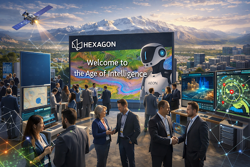
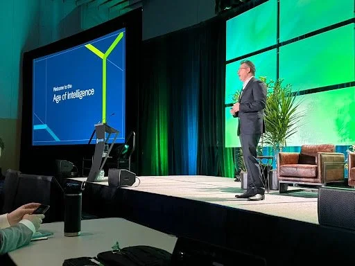
The overarching theme of Geo Week 2026 was crystallized during the keynote by Hexagon CTO Burkhard Boeckem. Standing before a screen that simply read, "Welcome to the Age of Intelligence," he described our current moment not as a settled state, but as the transition into the "Age of Intelligence." We are at a "violent tipping point" where traditional location science is being augmented—and sometimes hollowed out—by the unbridled scale of AI computation.
As someone who worked within the Hexagon ecosystem from 2013 to 2016, standing in that room felt like witnessing a tectonic shift. In those years, the focus was often on perfecting the sensor—capturing the most precise point cloud possible—and supporting the very software, like ERDAS IMAGINE, required to process that data into something actionable. At that time, we were masters of "capture and analytics."
Today, the mission has moved from "collection and processing" to "cognition." Boeckem’s vision for the "Age of Intelligence" is the natural evolution of those workflows. It signals that the industry is moving beyond just hardware and SaaS into the realm of Physical AI.
Hexagon’s recent strategic moves, including the spin-off of its software-centric Octave division and its foray into humanoid robotics with AEON, revealed at HexGeo 2025, serve as the physical evidence of this change. The sensors and processing engines I once supported are no longer just tools for human analysis; they are becoming the "eyes and brains" for autonomous systems that can reason and act within a digital twin.
This shift moves beyond static pixels toward "thermodynamic truth." A prime example highlighted during the week was the official completion of the USGS 3DEP baseline. This decade-long, $1 billion "moonshot" has successfully mapped the entire United States with high-resolution lidar. It creates the first continuous national "digital twin," a resilient foundation upon which all future spatial intelligence will be built.
AI as the New Digitizer: The gNext Proof
The most tangible evidence of this shift was found at the gNext booth. Drawing on my GEOINT background, I recognized that gNext is solving the "cognitive tax" inherent in traditional imagery analysis. Historically, an analyst’s time was consumed by the manual "grind" of scanning high-resolution raster imagery—a process where sheer volume often competes with the analyst's ability to maintain focus. While I’ve followed the theory of AI-assisted analysis for years, seeing it move from a "future concept" to a live, functional "wingman" was a watershed moment.
Their InspectAssist™ AI acts as a true force multiplier. By using computer vision to pre-identify and geolocate potential defects, the platform transforms the workflow from a search-based grind to a validation-based strategy. It doesn’t replace the analyst; it unburdens them. It allows the human expert to bypass the "noise" of thousands of redundant pixels and move straight to the high-priority "signals" that require professional judgment. Seeing this in person validated my own academic pivot: we aren't just learning to make better 3D models; we are learning to orchestrate the intelligence that lives inside them.

The Future of the Workforce Paradox
While the technological ceiling is rising, the industry is grappling with a critical "institutional lag." Research shared during the "Future of the Workforce" sessions—featuring a panel with Dr. Shawana Johnson, Jessica Touchard (CEO of GeoSearch), Grace Braver (a geospatial analysis graduate student at East Tennessee State University), and Edward Kunz—revealed a jarring paradox: while the demand for geospatial talent in North America is growing nearly five times faster than the rate of new graduates, the formal application process remains a significant hurdle.
Grace’s presence on the panel personified this gap. Despite her obvious technical acumen and drive, she shared the raw reality of the "entry-level" struggle—the financial weight of attending these high-level conferences and the algorithmic walls that often block even the most qualified graduates from reaching a human recruiter. Her story underscored a hard truth: the industry is hungry for talent, yet the traditional hiring "pipes" are often clogged by outdated metrics.
There is a unique symmetry to this struggle. Standing beside Grace as a fellow graduate student, I realized our challenges mirrored one another: I was working to re-integrate fifteen years of technology experience, while she was fighting to prove her fresh training deserved a human look. We both represent exactly what the industry calls for: veteran context and fresh innovation. Yet, we both face a system that treats resumes like code to be parsed rather than humans to be heard.
The consensus from the stage was clear: for students and veterans alike, the ROI of presence is 10/10. The exhibit hall serves as a 'vendor-neutral roof' where professionals can bypass the 'Institutional Lag' and connect directly with the technologies disrupting everything from AEC to Disaster Response. This is why 'showing up' at venues like Geo Week is non-negotiable; it offers more than just hardware—it provides a direct line into the industry’s human core.
The Geographical Conscience
Returning "full steam" to the geospatial world requires more than just updated technical certifications; it requires a reconnection with what I call the "geographical conscience." As we move toward a world defined by autonomous reality and AI-driven feature extraction, the human element remains the most valuable signal in the noise.
Geo Week 2026 proved that our global infrastructure depends on a workforce that can bridge the gap between automated optimization and human-centric truth. We need veterans with decades of context and sharp newcomers like Grace because we are the ones who turn "extracted features" into "infrastructure solutions." The future belongs to those who show up, build the "digital ceiling," and never forget the "operational floor."